Weather
Palm Desert Roasts In 'Excessive Prolonged Heat Wave' Through Mid-July
A long-duration heat wave will continue to impact inland areas through at least early next week, and here's when it will be the hottest.

PALM DESERT, CA —The mercury was expected to strike triple digits in Palm Desert and across the Inland Empire over the coming weekend, the National Weather Service warned. Meteorologists extended the current Inland Empire heat advisory through Tuesday, July 18 as they urged residents to take precautions when venturing or working outdoors amid skyrocketing temperatures.
This week, SoCal will meet thresholds for "significant heat impacts in the deserts and mountains, as well as portions of the Inland Empire," the NWS said in a statement Monday. "It will be in the 90s each day and potentially hotter ... in the Inland Empire, where a Heat Advisory goes into effect Tuesday."
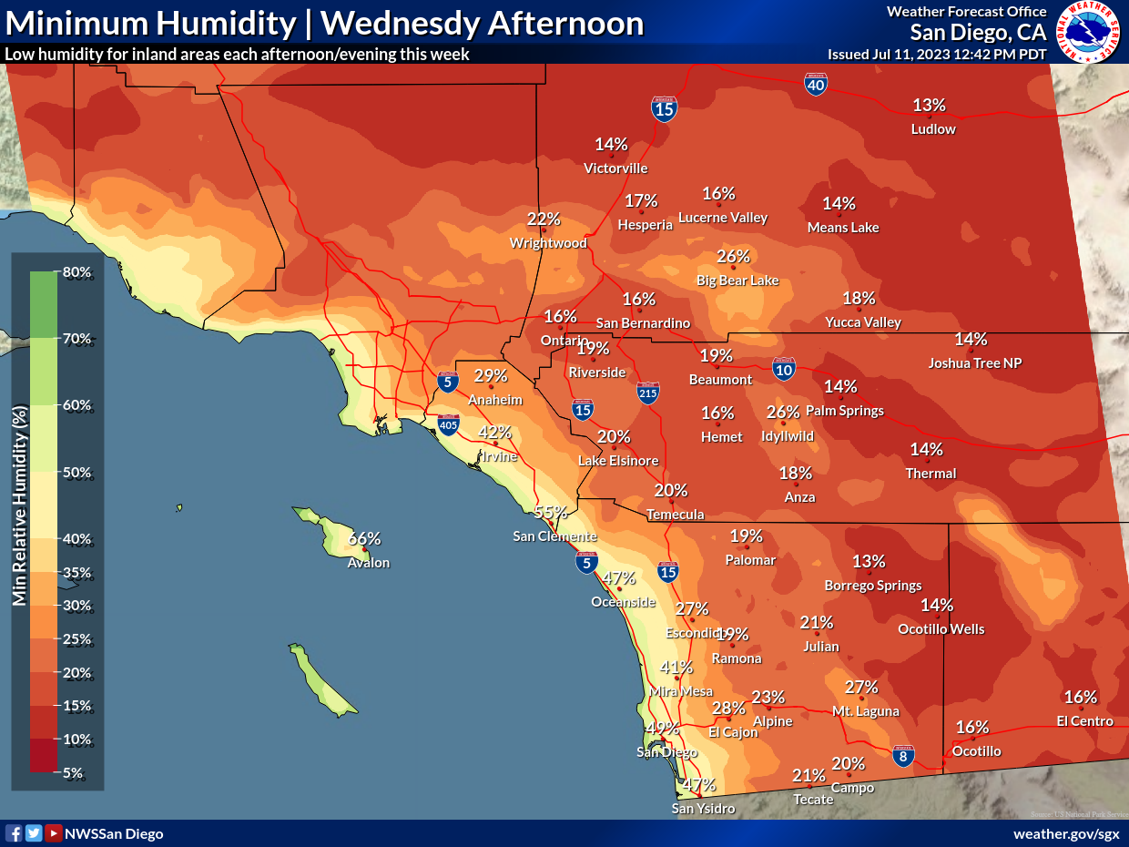
"Take extra precautions if you work or spend time outside," the Weather Service stated. "Drink plenty of fluids, stay in an air-conditioned room and stay out of the sun."
Find out what's happening in Palm Desertfor free with the latest updates from Patch.
Temps are likely to be 5 to 10 degrees above average this weekend into early next week, forecasters said, noting that a ridge of high pressure stalled over Arizona will expand westward, displacing moisture and drying out inland Southern California.
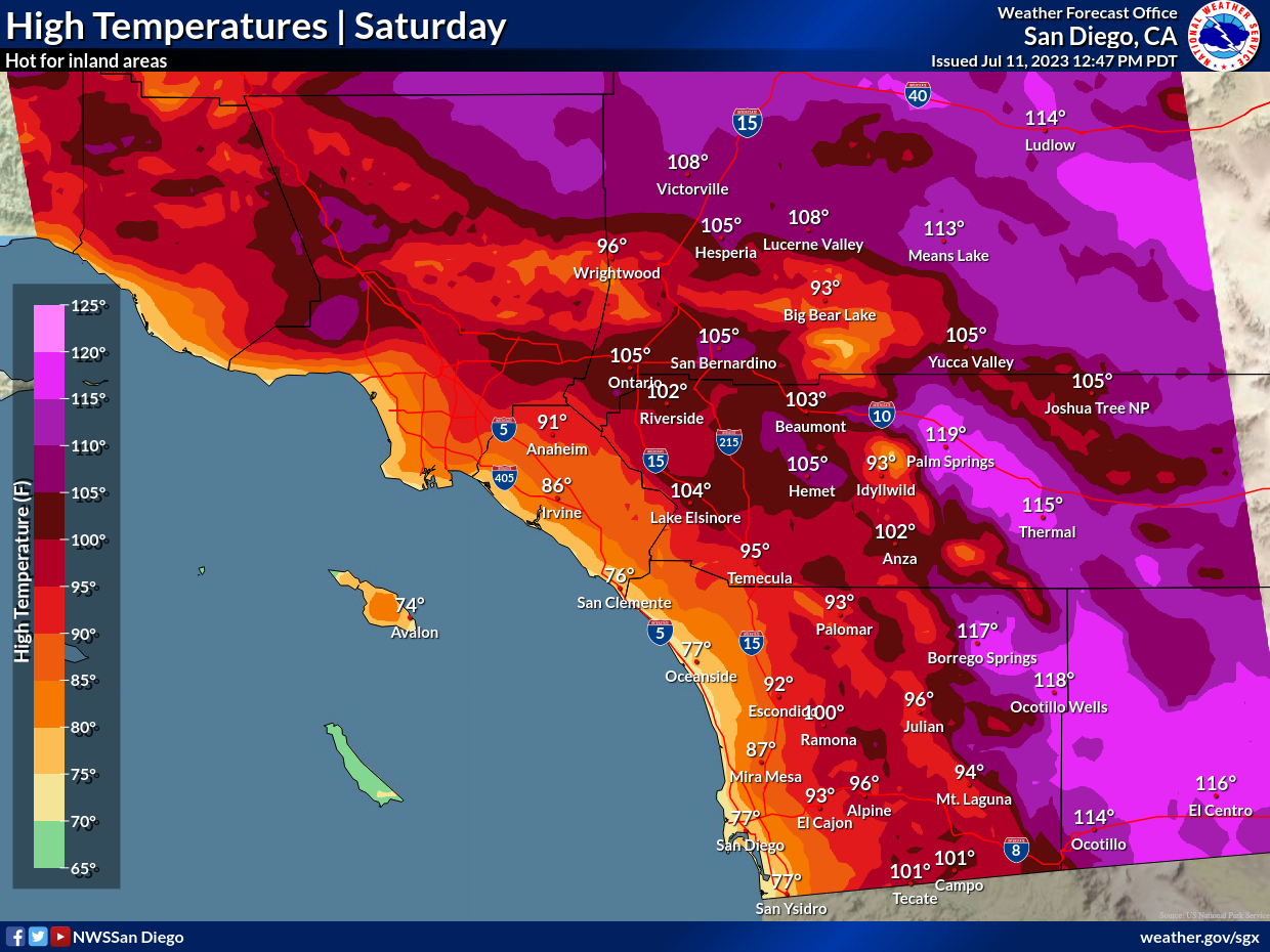
Daytime highs in the Coachella Valley was expected to stay around 115 degrees through the end of the week, with lows only dropping to the mid 80s, according to the NWS.
Find out what's happening in Palm Desertfor free with the latest updates from Patch.
In the Riverside metropolitan area, the highs from Tuesday to Saturday will peak at or just over 100 degrees, with overnight lows around 65, while in the Temecula Valley, coastal breezes and marine layers will keep the mercury from exceeding 90 for most of the week, with lows falling to around 60, forecasters said.
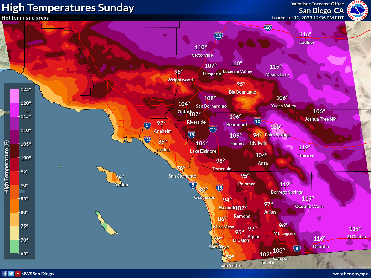
Sunday, the heat continues, with the hottest temperatures Saturday through Monday. Not only will daytime temperatures be very hot, but overnight low temperatures will be elevated, especially in the low deserts where lows will be 80-90 degrees. In the mountains and High Deserts, lows will only fall to the 70s. Widespread moderate to high heat risk is expected, with locally extreme heat risk in the deserts. Heat risk will be highest Saturday through Monday.
How hot will it get in Palm Desert?
The hottest day will likely be Sunday, when temperatures top 118 degrees in Southwest Riverside County, according to the National Weather Service.
Wednesday
Sunny and hot, with a high near 113. Light and variable wind becoming north 5 to 10 mph in the afternoon.
Wednesday night
Mostly clear, with a low around 87. Northwest wind 10 to 15 mph, with gusts as high as 25 mph.
Thursday
Sunny and hot, with a high near 114. Light and variable wind becoming northwest 10 to 15 mph in the afternoon. Winds could gust as high as 30 mph.
Thursday Night
Mostly clear, with a low around 88. Northwest wind around 20 mph, with gusts as high as 30 mph.
Friday
Sunny and hot, with a high near 116. Northwest wind 5 to 10 mph becoming southeast in the afternoon. Winds could gust as high as 20 mph.
Friday Night
Mostly clear, with a low around 91.
Saturday
Sunny and hot, with a high near 119.
Saturday Night
Mostly clear, with a low around 90.
Sunday
Sunny and hot, with a high near 118.
Sunday Night
Mostly clear, with a low around 90.
Monday
Sunny and hot, with a high near 117.
Monday Night
Mostly clear, with a low around 87.
Tuesday
Sunny and hot, with a high near 115.
Get more local news delivered straight to your inbox. Sign up for free Patch newsletters and alerts.