Weather
'Atmospheric River' Storm To Drench NorCal
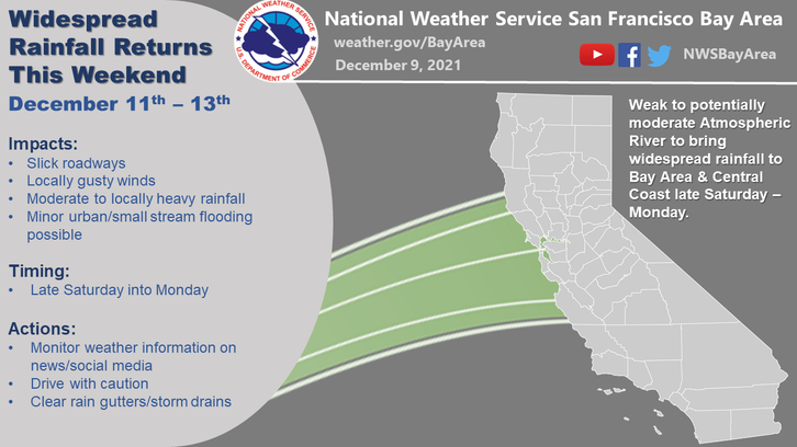
A powerful storm system was forecast to bring rain, intense winds and hazardous beach conditions to the Bay Area on Monday.


SAN FRANCISCO, CA — Another atmospheric river storm was predicted to hammer much of the Bay Area this week. Light rain and snow fell in Northern California on Sunday, giving residents a taste of what's to come.
The multiday storm could drop more than 8 feet of snow on the highest peaks and drench other parts of California as it pushes south and east before moving out midweek.
"This is a pretty widespread event," said National Weather Service meteorologist Anna Wanless in Sacramento. "Most of California, if not all, will see some sort of rain and snow."
Find out what's happening in San Franciscofor free with the latest updates from Patch.
Residents were urged to prepare for moderate to heavy rainfall, with the most rain likely expected to fall midday Sunday into Monday afternoon.
"So, now's the time to clear those gutters, check the wipers, and secure any loose outdoor objects!" Weather Service officials tweeted Saturday.
Find out what's happening in San Franciscofor free with the latest updates from Patch.
Residents can expect gusty winds, minor flooding in urban areas and small streams and slick roads. Drivers should use caution, and people should keep their rain gutters and storm drains clear at home, the weather service said.
Officials will monitor fire burn scar areas for potential debris flows but expect the rain to be overall beneficial. Debris flow is a risk in sloped areas following a large wildfire and can cause more injuries than the wildfire itself.
Some thunder is possible Monday off the coast.
The Bay Area has not seen widespread rain since October's "bomb cyclone" storm, which brought historic rainfall, toppled trees, flooded busy highways and homes, prompted evacuations and cut power to about 380,000 people.
Are you ready? A strong storm system will bring us widespread rain, gusty winds, and hazardous beach and marine conditions late tonight into early next week. So now's the time to clear those gutters, check the wipers, and secure any loose outdoor objects! #cawx pic.twitter.com/6ZMeepZBmq
— NWS Bay Area (@NWSBayArea) December 11, 2021
Atmospheric rivers are "relatively long, narrow regions in the atmosphere — like rivers in the sky," according to the National Oceanic and Atmospheric Administration. A bomb cyclone occurs when a storm undergoes bombogenesis, meaning it rapidly intensifies over a 24-hour period, according to NOAA.
The markets are especially busy this time of year with farmers making jellies, jams and sauces for the holidays, he said. And, he said, rain always is needed in a parched state.
“In many ways, it really is a blessing,” Naja-Riese said.
Lichen Crommett, manager of the San Lorenzo Garden Center in Santa Cruz, California, said customers weren't deterred by a light sprinkling of rain Sunday morning.
“It’s not like raincoat worthy just yet, but any second it could change,” she said.
A second storm predicted to hit California midweek could deliver almost continuous snow, said Edan Weishahn of the weather service in Reno, which monitors an area straddling the Nevada state line. Donner Summit, one of the highest points on Interstate 80 and a major commerce commuter route, could have major travel disruptions or road closures, Weishahn said.
The weather follows a calm November that was unseasonably warm.
“With this storm coming in, it's going to be a wakeup call to a lot of folks,” Weishahn said.
The Associated Press contributed to this report.
Get more local news delivered straight to your inbox. Sign up for free Patch newsletters and alerts.