Weather
Damaging Winds, More Rain Hits The Bay Area: Storm Forecast
Wind warnings and advisories will stay in place until the evening, and the rain will stick around a little longer. Here's what to expect.


SAN FRANCISCO — Rain, wind and isolated thunderstorms were forecast in the Bay Area Tuesday as a strong Pacific storm system sweeps across the Golden State. The latest, wind-fueled push of moisture was already soaking Southern California in the morning, where the storm's impact is expected to be the most severe.
While the Bay Area should see less dramatic precipitation, there is still the potential for areas of excessive rain, and strong winds could spur power outages across the region
Some changes to @NWSWPC excessive rainfall outlook brought an expansion to the Marginal and Slight risk areas. Follow up on their discussion here- https://t.co/DCTdU5g94Z pic.twitter.com/TuSF13KUO2
— NWS Bay Area 🌉 (@NWSBayArea) March 21, 2023
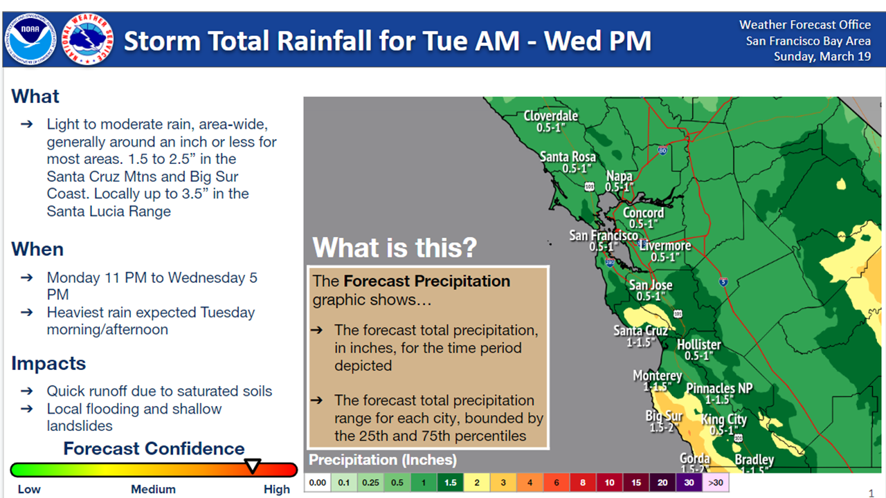
Most communities can expect light to moderate rain through Wednesday afternoon, with the heaviest due by Tuesday afternoon. Generally, forecasters see less than an inch of rain around San Francisco, Napa and Concord, with a little more favored for Santa Cruz, Monterey and other points south.
Find out what's happening in San Franciscofor free with the latest updates from Patch.
The Santa Cruz Mountains and Big Sur could pick up 2.5 inches of rain, and up to 3,5 inches is possible over the Santa Lucia Range.
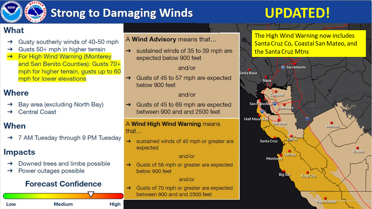
A wind advisory will be in place for the Bay Area — except for the North Bay — and Central Coast until 9 p.m. Tuesday. Forecasters predict sustained winds of at least 35 mph, with gusts hitting the high 50s for elevations below 500 feet.
Find out what's happening in San Franciscofor free with the latest updates from Patch.
Monterey and San Benito counties meanwhile will be under a high wind warning, with gusts as high at 60 mph at lower elevations and topping 70 mph at higher elevations.
"The bigger concern for the day will be with the winds," NWS Bay Area forecasters wrote Tuesday. "Several sites are already gusting between 45 and 60 mph, with Highlands Peak being the winner so far with a gust to 75 mph. Meanwhile, the Salnias Valley and the Monterey Bay are starting to see gusts in the 30 to 40 mph [range]."
A few thunderstorms may also enter the fray Tuesday, with the highest likelihood looking south.
"Isolated thunderstorms will be possible today, mainly in the vicinity of Monterey Bay and areas southward, where [there is] the greatest instability," forecasters said. "Any thunderstorms that do develop will be capable of producing small hail and gust winds. Cannoy rule out an isolated water spout either."
The winds should begin to ease Tuesday evening into Wednesday as conditions turn more showery. There will even be a chance for some sun as the storm moves out. Temperatures will continue to trend below average for the season, but mostly clear skies are in the forecast until Sunday night. Rain returns to the forecast Monday.
Get more local news delivered straight to your inbox. Sign up for free Patch newsletters and alerts.