Weather
Atmospheric River Barrels Toward NorCal With Heavy Rain, Snow And Potential Flooding
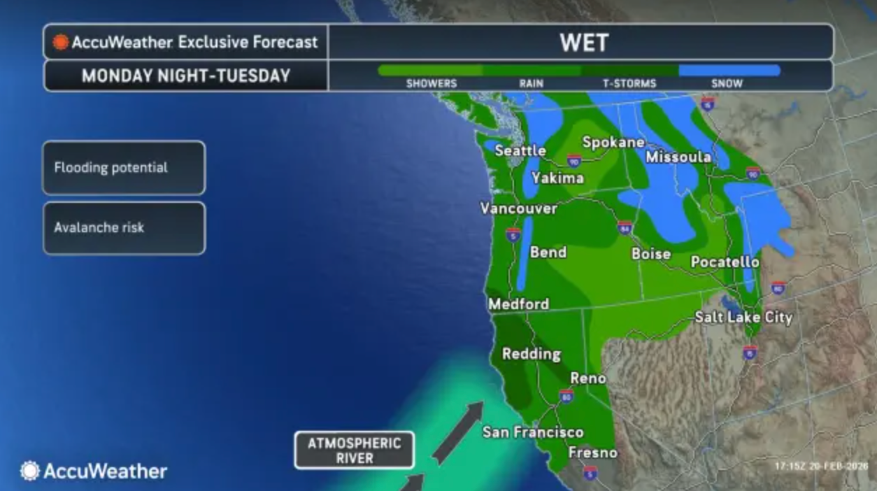
The new system is targeting the state just days after another storm dumped significant snow in the mountains and rain at lower elevations.

Another storm is poised to hit parts of Northern California this weekend and is likely to bring drenching rain and heavy mountain snow to parts of the region, according to the latest forecasts.
The new system is targeting the state just days after another storm dumped significant snow in the mountains and rain in areas of lower elevations. Before Thursday's storm, the 72-hour snowfall totals in parts of the Sierra Nevada ranged from just over 12 inches in southern areas to nearly 8 feet in central and northern parts of the range, according to an AccuWeather report.
In just the past week, 92.5 inches of snow were recorded at the Central Sierra Snow Lab. The mountain powder has drawn crowds to the resorts in what has turned out to be a deadly combination. Nine skiers are presumed dead in a backcountry Tahoe avalanchethis week, and three more skiers died in ski resort accidents.
Find out what's happening in San Franciscofor free with the latest updates from Patch.
The incoming storm system is likely to move into Northern California from the Pacific Northwest on Sunday before moving south through Tuesday.
Find out what's happening in San Franciscofor free with the latest updates from Patch.
"The southward extent of the rain and mountain snow will depend on the track of the storm," AccuWeather forecasters said Saturday. "The intensity of the rain and snow may hinge on the development and forward speed of a long plume of Pacific moisture, called an atmospheric river."
Currently, a winter storm warning is in place for parts of far northern California, including Siskiyou and Trinity counties, from 10 p.m. Saturday until 4 p.m. Sunday.
In Siskiyou County, accumulations of 5 to 10 inches of snow are expected above 4,500 feet, according to the National Weather Service. Meanwhile, up to 12 inches of snow could fall in Trinity County. Additionally, south to southeast winds are forecast to gust as high as 60 mph and could make travel impossible.
According to the National Weather Service, the heaviest snow is expected late Saturday night through Sunday morning. Snow levels will begin to rise on Sunday afternoon, shortly before snow tapers off.
The rest of Northern California is likely to get torretial rain as the system moves south.
Light rain is likely to develop north of the Golden Gate by late morning, according to San Francisco Chronicle meteorologist Greg Porter. Drizzle or spotty showers are likely farther south into San Francisco and the East Bay through the afternoon. Most locations won't see much accumulation, forecasters said.
A greater chance for accumulating rain will come Monday into Tuesday, should the atmospheric river develop. In the Bay Area, there's a possibility that 2 to 3 inches of rain could fall, while the rest of the region will likely see 1 to 1.5 inches.
"Given the southwest orientation of the moisture, this would be a warm storm system, potentially dropping rain at high elevations of the Sierra," Porter said. "Rain on top of freshly fallen snow can compound flooding danger."
Higher rainfall totals are expected north of the Bay Area, where up to 4 to 6 inches could fall, according to the National Weather Service. Minor flooding of small streams, creeks and areas with poor drainage could occur.
Get more local news delivered straight to your inbox. Sign up for free Patch newsletters and alerts.

