Weather
Weekend Frost Concerns; More Rain & Wind Next Week: Bay Area Forecast
The Bay Area is in for a string of unusually cold mornings, especially troubling for the wine country where vines have begun to bud.


SAN FRANCISCO — Dry, chilly weather will stay in place through the weekend across the Bay Area, with some very cold mornings ahead, and forecasters are growing more certain about wet and gusty weather returning next week.
In the short term, the National Weather Service will be closely monitoring the North Bay, where frost and freezing overnight temperatures are in the forecast. Lows will run unseasonably cold across the board.
"The cold air will be more settled into our region over the weekend, so [we] have expanded the Frost Advisory to include much of the East Bay, South Bay, Santa Cruz Mountains, Hollister & Salinas valleys, and the interior mountains of Monterey & San Benito counties," NWS Bay Area announced Friday. "Probabilities of early morning lows being at or below 35 degrees rises on Saturday and Sunday becoming 50 to 80 percent for interior locations."
Find out what's happening in San Franciscofor free with the latest updates from Patch.
A weekend of unseasonably low temperatures starts tonight, with near freezing temperatures expected in the interior valleys. #CAwx pic.twitter.com/NZDZ4yrHLP
— NWS Bay Area 🌉 (@NWSBayArea) March 24, 2023
Afternoon highs are unlikely to provide much relief, ranging from 5 to 12 degrees below normal and topping out in the 50s. The cold snap will present several hazards, especially for people living unsheltered or without adequate heating. In the North Bay, the potential for frost could spell big impacts for the wine country, where vines are already in bud break.
"With temperatures dropping into the low to mid-30s for the next several mornings, then anyone without power in their home or folks without adequate shelter will be susceptible to cold exposure," forecasters warned Friday. "At this point, Sunday continues to look to be the coldest, and it's looking like even Monday morning has the potential to be quite chilly."
Find out what's happening in San Franciscofor free with the latest updates from Patch.
The weather service expects the coldest hours will generally be between 4 a.m. and 9 a.m. Temperatures will improve as the next storm rolls in Monday, but familiar hazards will return.
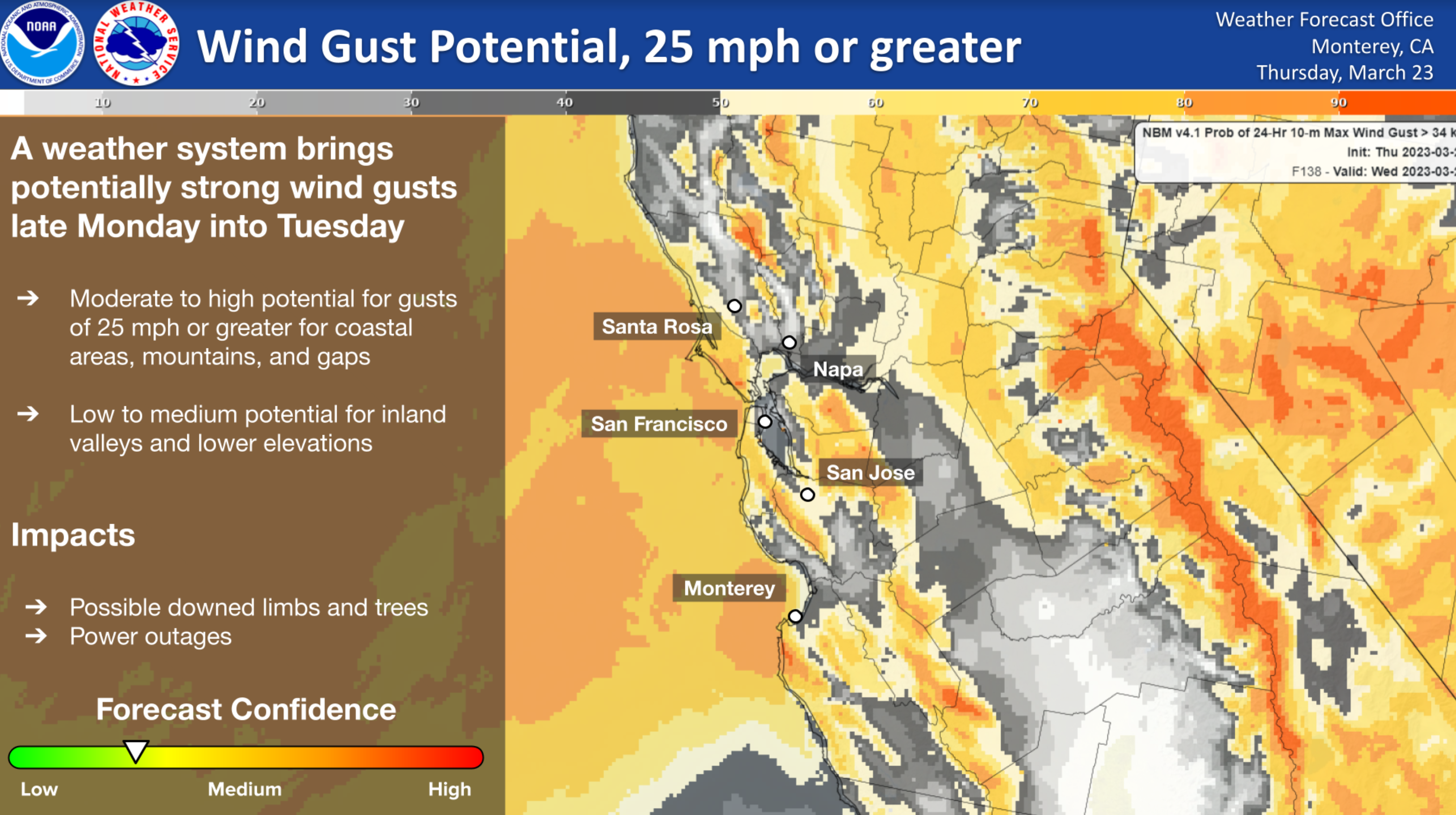
While a few specifics are still up in the air, forecasters are increasingly confident in some degree of heavy rain coupled with wind gusts.
"Bottom line: all the threats we've been mentioning for the March storms so far will be in play next week," forecasters said. "Downed trees, power outages, flooding, rises in creeks/streams. Continue to stay prepared and look out for neighbors if needed. The brunt of it still looks to occur Tuesday."
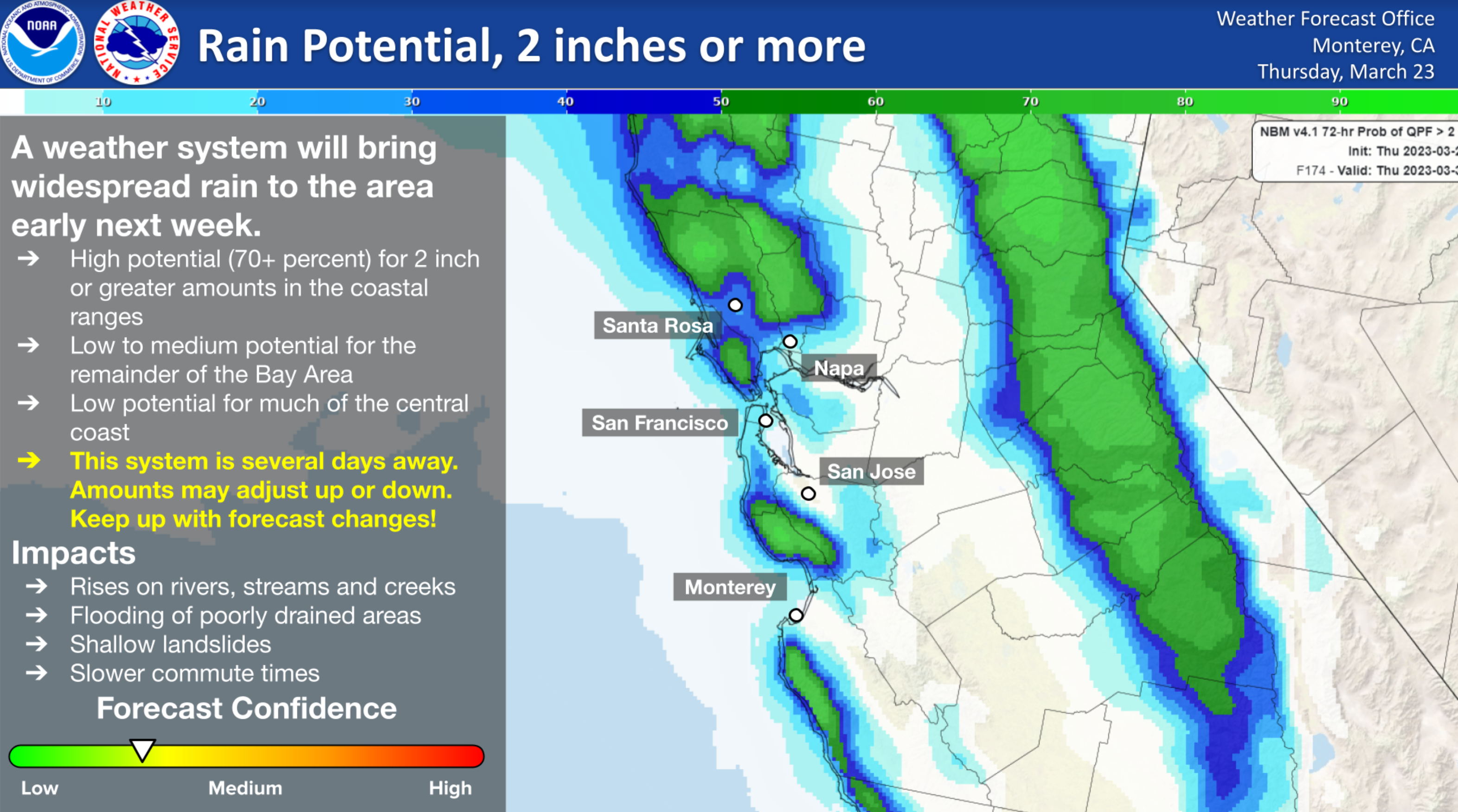
Generally, forecasters said everyone should be prepared for at least a half-inch of rain Monday and Tuesday, with up to 2.5 inches possible along the coast, but that outlook could change as the storm draws near. The models are in agreement on low pressure, which means winds are very likely to become an issue, especially Tuesday afternoon.
Get more local news delivered straight to your inbox. Sign up for free Patch newsletters and alerts.