Community Corner
Handout From Aug 27 2018 FEMA Flood Zone Belle Air School Meeting
U P D A T E D Property outlined in RED. Introductory words by Jimmy Tan. Flood Zone handouts

Article Source: Robert Riechel
Last night (August 27 2018) personnel from FEMA along with Jimmy Tan from the City of San Bruno along with San Mateo County Supervisor President Dave Pine and along with District Manager Brian Perkins from U.S. Assemblywoman Jackie Speier local office participated in an informational meeting held at the Belle Air School to discuss the proposed FEMA Flood Zone Map that will show much of the Belle Air District (from 4th Ave to 7th Ave and from the Belle Air School north the the SSF City limits in the flood zone.
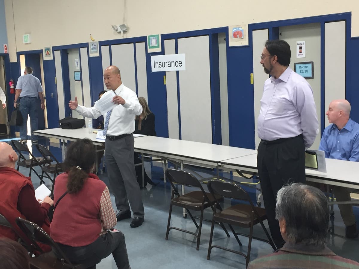
ABOVE L: San Bruno's Jimmy Tan R: FEMA representative
Find out what's happening in San Brunofor free with the latest updates from Patch.
San Bruno's Jimmy Tan started the meeting with the following words:
Good evening. I would like to thank everyone for coming tonight to attend this very important meeting. Many of you may or may not be aware that the City has been in communication and coordination with FEMA for approximately four years on this flood map issue. The City first learned about the flood maps towards the end of 2014. We knew right away that there would be financial impacts to the property owners so we proactively began a plan to help our residents the best we can. The City hired an engineering consulting firm to help analyze the flooding sources. Once our detailed analysis was completed, we believed that FEMA’s hydraulic model was really conservative which showed more properties in the flood zone in comparison to City’s results. Therefore, the City submitted an appeal to FEMA. The City received support from both Congresswoman Jackie Speier’s and Supervisor David Pine’s offices who wrote letters of support on behalf of San Bruno’s appeal.
Find out what's happening in San Brunofor free with the latest updates from Patch.
The City didn’t have to submit an appeal and could have elected to accept FEMA’s maps like other agencies in San Mateo County. But the City chose to submit an appeal because we believed that we should help our residents and do everything we can for them to ensure the residents receive full support from the City to seeing this issue until the end.
The City’s appeal was denied by FEMA but we continued and submitted the application to FEMA right away requesting the Scientific Resolution Panel or SRP which is the last step in the appeal process. We wanted the SRP to review our analysis and provide independent review of our findings. In April of this year, the City was informed by the SRP denying the appeal. The entire appeal process delayed the issuance of FEMA’s final map for more than 3 years.
Although our appeal was denied, the City is continuing to work on this issue. We are currently working closely with the County of San Mateo and City of South San Francisco to study one of the flooding source and trying to determine how we can mitigate the issue. In addition, the City has been coordinating with San Francisco Airport staff on their work efforts to improve the shoreline protection surrounding the airport. The City will benefit from the completion of the projects in South San Francisco and the airport. We will then coordinate with FEMA to get most of our residents out of the flood zone through Letter of Map Revision process.
Tonight, FEMA representatives are here to assist to answer any questions you may have on the FEMA issues. Three tables are setup with FEMA representatives to discuss any issues you may have in regards to flood insurance and its cost, flood maps and building improvements. From our previous discussions with FEMA representatives, property owners should purchase flood insurance early to get the best discounted rate. Interpreters are available at each table as well to assist, if needed.
The City posted a lot of documents that you see on the table tonight and more on the City’s website. The correspondences between FEMA, appeal reports and other FEMA documents are all on the website for your information. Thank you again for coming to tonight’s meeting.
(it was to be just information tables and no formal presentation) with a brief background on the steps the City along with the City of South San Francisco had taken that got us to where we were.
Where we are is that FEMA rejected the report from the consultant hired by San Bruno and SSF who came up with a much smaller flood impacted area.
A request was made to President Trump to have someone higher up in FEMA review the local FEMA results along with the consultants and the answer received August 25 2018 upheld the local FEMA findings.
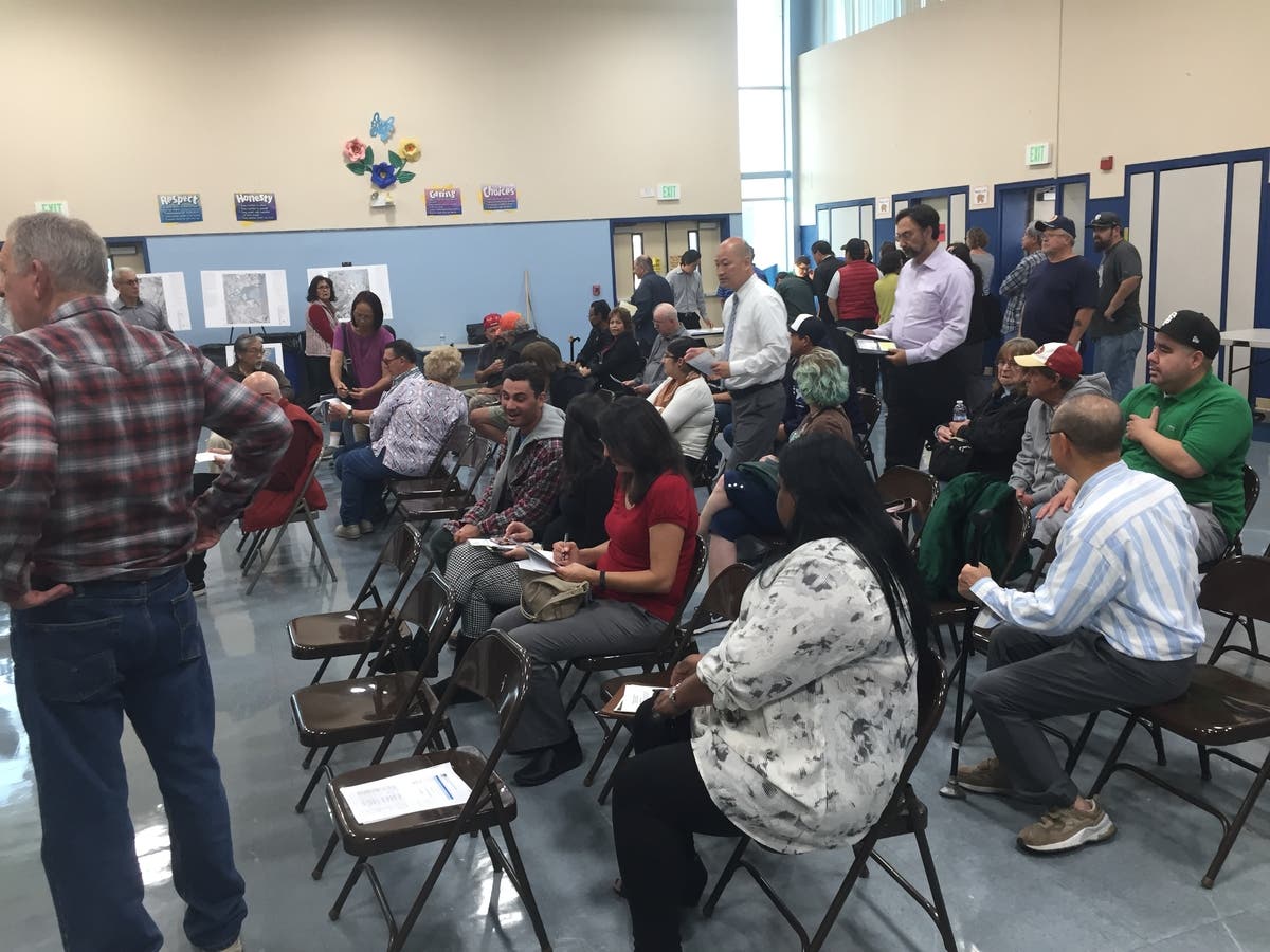
The meeting, to which about 50 residents attended, moved into at least 45 minutes of questions:
Jimmy Tan answered a few
Supervisor Dave Pine answered a few
2 from FEMA answered a few BUT
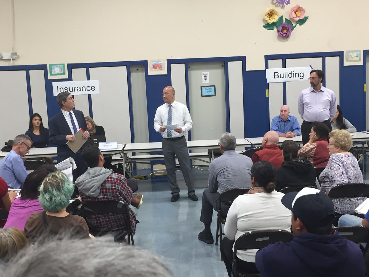
ABOVE L: Brian Perkins C: Jimmy Tan R: FEMA representative
U.S. Congresswoman Jackie Speier's District Manager answered most of the questions and in great depth. Brian appeared to have a very detailed understanding of both sides of the situation. Brian had been working with both cities and the consultant (for over a year) and assisted Congresswoman Speier in her writing of a very detailed letter to FEMA (which FEMA rejected).
The meeting then broke into groups speaking to the Insurance Info table representatives, and many asked questions about the various maps on display.
BELOW are the handouts available
_1-1535497970-9243.jpg)
_2-1535497996-8972.jpg)
_3-1535498018-6382.jpg)
_4-1535498056-2393.jpg)
_5-1535498080-3987.jpg)
_6-1535498104-79.jpg)
_7-1535498123-1485.jpg)
_8-1535498148-2851.jpg)
_9-1535498171-2073.jpg)
_10-1535498193-220.jpg)
_11-1535498212-9544.jpg)
_12-1535498233-705.jpg)

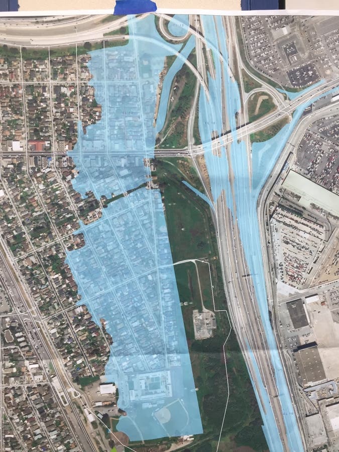
ABOVE The BLUE area is in the proposed FEMA Flood Zone
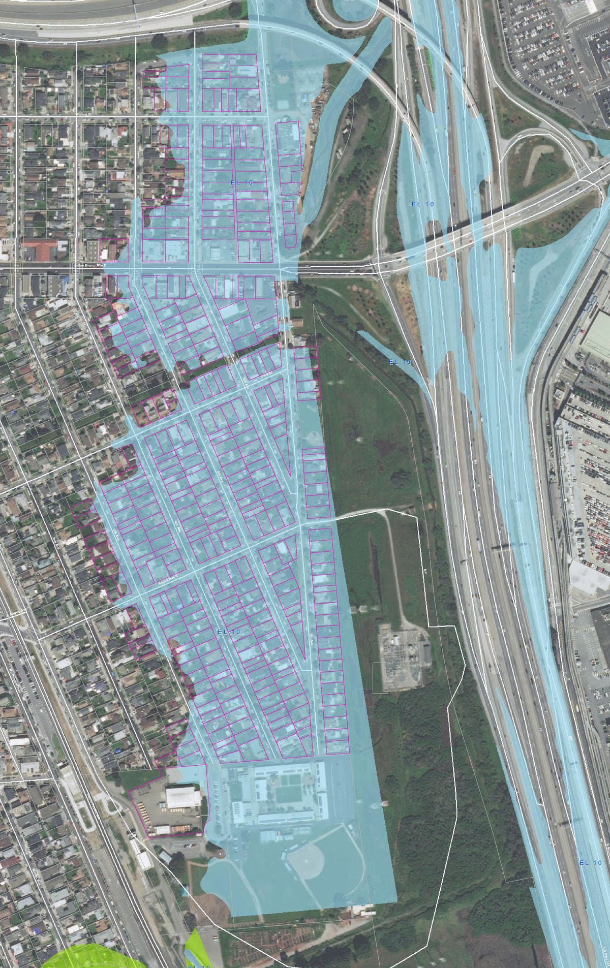
ABOVE FEMA map with individual properties outlined in RED.
The above red outlined map can be downloaded from:
https://www.sanbruno.ca.gov/civicax/filebank/blobdload.aspx?BlobID=29563
Hopefully the City will post this map on their web page so YOU can download and enlarge it to see YOUR specific property.
Thank you to FEMA for adjusting their initially planned just manned info tables to include their presentations and time for the many questions and for having Congresswoman Speier's District Manager Brian Perkins available to provide his answers.
There should be a need to have an additional such meeting to specifically answer INSURANCE questions when the 12 month Insurance Enrollment Window opens.
=
Robert Riechel
Send your articles and photos to:
E=Mail: SanBrunoPatch.Robert@Yahoo.com
My Posts: http://patch.com/users/robert-riechel
Photo Credit: San Bruno CA Patch Archives
Source Credit: San Bruno Patch Contributor Robert Riechel
CLICK on link below to Subscribe to News Alerts and a Daily Email Newsletter for San Bruno Patch
http://link.patch.com/join/3-0-subscribe?list=US_CA_SANBRUNO_282
#SanBrunoPatch
What is Patch?
Patch is an independent U.S. local news and information platform. We operate in over a thousand hyperlocal locations in all 50 states and Washington, D.C.. We're a community-specific news, information and engagement network driven by passionate and experienced media professionals.
Want to get involved?
Here's what you can do:
· Contribute content! Patch welcomes and encourages community members to post directly to the site by signing up using My Patch
· Keep up with news and events by subscribing to your local Patch updates
· Learn more about local businesses and the people behind them
· Participate in discussions
CLICK on link below to Subscribe to News Alerts and a Daily Email Newsletter for San Bruno Patch
http://link.patch.com/join/3-0-subscribe?list=US_CA_SANBRUNO_282
#SanBrunoPatch