Community Corner
MUST SEE: Drone Video Offers Aerial View of Napa Quake Damage
This video captured by a man's quadcopter drone provides a bird's eye look at the damage.

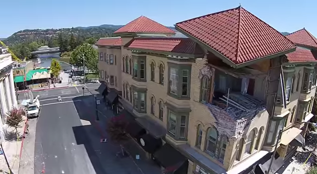
A unique video published following Sunday’s South Napa Earthquake shows what the damaged town looks like from above.
The video was published to YouTube Sunday by Evan Kilkus and lasts for just under 7 minutes as the drone flies over things like cracked facades and crumbled bricks.
“This video is intended for educational purposes to show the damage caused to historic and new buildings in Napa,” the video’s introduction states. “This video is also intended to show how a quadcopter/drone can be used to help and asses damage.”
Find out what's happening in South San Franciscofor free with the latest updates from Patch.
As of Tuesday, the city of Napa has identified at least 49 buildings that are too damaged to allow people inside. They’ve been “red-tagged.”
Find out what's happening in South San Franciscofor free with the latest updates from Patch.
More than 100 other buildings have been yellow-tagged, allowing residents and business owners to go inside for limited purposes, and that number is expected to rise as inspections continue.
[Related: BAY AREA QUAKE: Click here for Patch’s Full Earthquake Coverage.]
Check out the map below, as provided by the City of Napa, for the latest on where the damage is located.
Get more local news delivered straight to your inbox. Sign up for free Patch newsletters and alerts.