Weather
First Snowfall Projections Released As Massive Storm Forecast This Weekend In CT
A massive storm is forecast to produce significant impacts on Connecticut. Here's the latest details on what to expect.

We all know there is a big snowstorm coming to Connecticut and now we're beginning to talk some numbers too.
On Wednesday afternoon, WFSB chief meteorologist Mark Dixon reported that a foot or more of snow appears possible at this point.
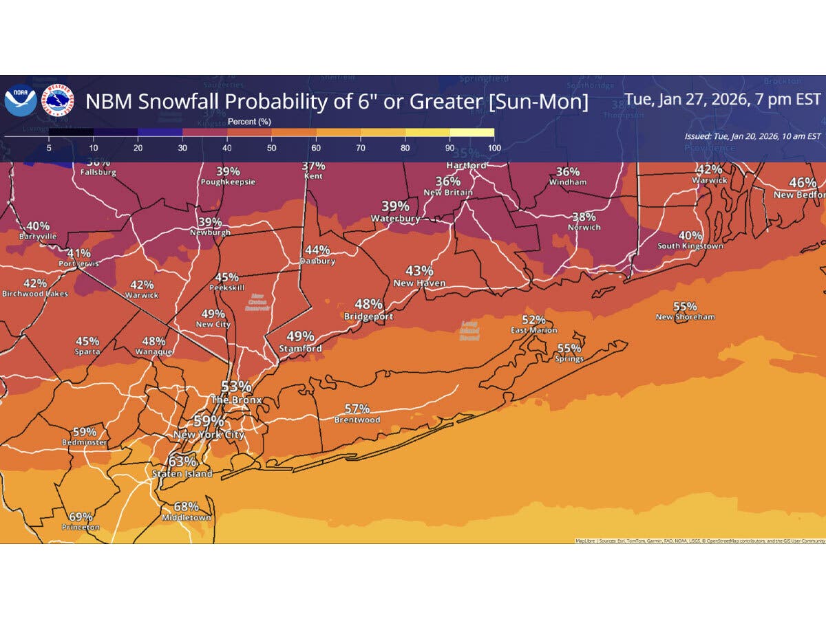
NBC Connecticut chief Meteorologist Ryan Hanrahan said providing an exact number is difficult this far out from the storm's arrival. He did state in a social media post that the European model shows an 80 percent chance of six or more inches of snow and a 10 percent chance of a foot or more.
Find out what's happening in Across Connecticutfor free with the latest updates from Patch.
"As we get closer, the details will sharpen, and I’ll absolutely get more specific when it’s responsible to do so," Hanrahan wrote in a social media post.
Fox 61 chief meteorologist Rachel Frank wrote "we have a WEATHER IMPACT ALERT for at least 6"+ of snow Sunday into Monday. 12" is possible but less of a guarantee!"
Find out what's happening in Across Connecticutfor free with the latest updates from Patch.
The National Weather Service reports the storm will impact Connecticut starting on Sunday and lasting into Monday. In a hazardous weather outlook issued Wednesday, it said, “Confidence is increasing in the potential for a significant winter storm to impact the area Sunday into Monday with accumulating snowfall.”
Timeline for the big storm
For Sunday, the weather service is predicting an 80 percent chance of snow, mainly after 4 p.m.
The National Weather Service’s New York office reports snow in Connecticut could begin early Sunday morning and last into a portion of Monday.
It indicated the exact timing and amounts will become clearer as the week progresses.
“We are monitoring a growing potential for a plowable snowfall event Sunday into Monday. There is a moderate potential we could exceed 6 inches of snow from a low pressure system that will pass to our south. Monitor the forecast for changes as we approach the weekend,” the National Weather Service reports.
The National Weather Service’s Weather Prediction Center urges people to start preparations now.
According to WTNH, heavy snow develops during the morning Sunday and is expected to continue throughout the day and Sunday night, with some sleet mixed in on the shoreline
WTNH reports it is “watching a southern storm system that will send snow our way Sunday into Monday! The potential for higher snow amounts & a high impact storm is increasing!”
Big snow amounts possible, according to WTNH's Gil Simmons
WTNH Meteorologist Gil Simmons reports that all models agree on the Sunday to Monday morning snowstorm with “big amounts possible.” Simmons predicts there will be heavy snow Sunday into Sunday night, tapering to snow showers on Monday.
Read More:
- 22-Year-Old Fatally Shot In Broad Daylight: Police
- Women Attacked By Feral Cat: Animal Control
- Popular Restaurant Hit With Sanctions, Fine For Liquor Control Violations
Minor snow possible tonight
In the short term, Simmons anticipates Connecticut could get between a coating and two inches of snow on Wednesday night.
Here are the forecast details for southern Connecticut via the National Weather Service:
Tonight: A chance of snow between 7pm and 1am. Cloudy, then gradually becoming partly cloudy, with a steady temperature around 35. Southwest wind around 8 mph. Chance of precipitation is 40%.
Thursday: Mostly sunny, with a high near 42. Southwest wind 8 to 13 mph.
Thursday Night: Partly cloudy, with a low around 23. West wind around 7 mph.
Friday: Partly sunny, with a high near 34. Wind chill values between 15 and 25. West wind 6 to 13 mph.
Friday Night: Partly cloudy, with a low around 7. Northwest wind 9 to 11 mph, with gusts as high as 24 mph.
Saturday: Mostly sunny and cold, with a high near 17.
Saturday Night: A 50 percent chance of snow after 1am. Mostly cloudy, with a low around 7.
Sunday: Snow. High near 21. Chance of precipitation is 80%.
Sunday Night: Snow. Low around 15. Chance of precipitation is 80%.
Monday: A 50 percent chance of snow. Mostly cloudy, with a high near 26.
Here are the forecast details for northern Connecticut via the National Weather Service:
Tonight: A chance of snow, mainly before midnight. Patchy fog between 9pm and 11pm. Otherwise, mostly cloudy, with a low around 26. South wind 7 to 10 mph, with gusts as high as 20 mph. Chance of precipitation is 50%. Total nighttime snow accumulation of less than one inch possible.
Thursday: Mostly sunny, with a high near 42. West wind 9 to 14 mph, with gusts as high as 24 mph.
Thursday Night: Partly cloudy, with a low around 19. West wind around 6 mph.
Friday: Partly sunny, with a high near 30. Southwest wind 6 to 14 mph, with gusts as high as 26 mph.
Friday Night: Partly cloudy, with a low around 3. Northwest wind 11 to 14 mph, with gusts as high as 25 mph.
Saturday: Mostly sunny, with a high near 13. Northwest wind around 11 mph, with gusts as high as 23 mph.
Saturday Night: Mostly cloudy, with a low around 4. Northwest wind around 6 mph.
Sunday: Snow, mainly after 9am. High near 17. Northeast wind 6 to 10 mph, with gusts as high as 20 mph. Chance of precipitation is 80%.
Sunday Night: Snow. Low around 12. North wind around 10 mph, with gusts as high as 20 mph. Chance of precipitation is 80%.
Monday: Snow likely, mainly before 9am. Mostly cloudy, with a high near 23. North wind 7 to 10 mph. Chance of precipitation is 60%.
Monday Night: A chance of snow. Mostly cloudy, with a low around 5. Northwest wind 6 to 8 mph. Chance of precipitation is 30%.
Get more local news delivered straight to your inbox. Sign up for free Patch newsletters and alerts.