Weather
Snow Accumulation Estimates Increase For CT: Winter Storm Warning Issued
Find out the latest snow accumulation estimates and timeline for the upcoming major winter storm from meteorologists.

UPDATE: The National Weather Service has issued a winter storm warning for Hartford, Tolland, Litchfield, and Windham counties from 7 a.m. Sunday to 8 p.m. Monday.
"Heavy snow expected. Total snow accumulations between 12 and 17 inches. Winds gusting as high as 30 mph....Roads, and especially bridges and overpasses, will likely become slick and hazardous. Travel could be very difficult to impossible, especially if traveling overnight into the Monday morning commute. The hazardous conditions could impact the Monday morning and evening commutes.
The National Weather Service also issued a winter storm warning for all of southern Connecticut from 3 a.m. Sunday to 6 p.m. Monday.
Find out what's happening in Across Connecticutfor free with the latest updates from Patch.
"Heavy snow expected. Total snow accumulations between 12 and 16 inches....Roads, and especially bridges and overpasses, will likely become slick and hazardous. Visibilities may drop below 1/4 mile due to falling and blowing snow."
Latest snowfall forecast updated below, along with upgrades to winter storm warnings for the entire area from early Sunday through much of Monday. Totals have increased a bit across the interior and decreased slightly southeast portions of the area. pic.twitter.com/Qfxx35Sbus
— NWS New York NY (@NWSNewYorkNY) January 23, 2026
Original post: The weekend storm system could bring up to 18 inches of snow to parts of Connecticut, though most of the state will get about a foot, according to the National Weather Service.
Find out what's happening in Across Connecticutfor free with the latest updates from Patch.
It has a winter storm watch in effect for early Sunday through Monday afternoon.
Litchfield County is expected to get the highest totals, with total snow accumulation between a foot and 18 inches possible, according to the National Weather Service.
Its forecasters predict most of interior Connecticut’s snow totals will be between eight and 15 inches.
Southern Connecticut is expected to get between eight and 14 inches, with locally higher amounts possible. Sleet may mix in with the snow in southern areas of the state, reducing the total accumulation, the National Weather Service said. Coastal Connecticut is expected to get the lower end of the range.
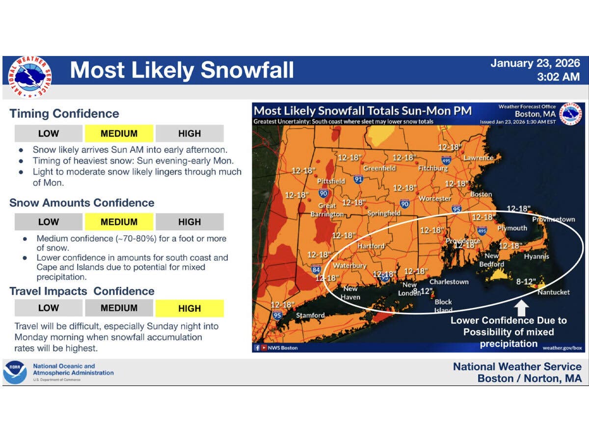
Snow may fall at a rate of more than an inch an hour at times, especially on Sunday night, the National Weather Service said.
Travel is expected to be difficult, with hazardous road conditions and reduced visibility, and the National Weather Service advises delaying any travel if possible.
Timeline for the snow and local experts predictions
WFSB predicts the storm will start late Sunday morning, peak Sunday night and then end on Monday.
“Precipitation will be all snow from beginning to end (and of the fluffy variety for inland CT),” WFSB reports.
The exception, according to WFSB, is southeastern Connecticut, where there could be mixed precipitation, lowering totals.
“By the time it’s all done, plowable amounts of snow are likely with at least a foot of snow inland (perhaps up to a foot and a half),” WFSB reports. “The shoreline could see amounts closer to a foot (perhaps less) if mixing were to take place.”
WTNH is forecasting 12 to 15 inches of snow in inland Connecticut, and between eight and 12 inches in southern and shoreline areas. Its meteorologists predict snow develops around 8 a.m. Sunday and will end Monday morning.
NBC Connecticut’s meteorologists say snow will move into Connecticut from the south starting around midday on Sunday. The station as of Friday predicts 10 to 18 inches of snow statewide.
Fox 61 says it is “still fine tuning the track” of the snowfall - but it predicts a foot or more to fall.
“It’s looking more and more like heavy snow will arrive. 12" + of snow is looking likely across much of the state,” Fox 61 reported Friday.
Read More:
- Popular Restaurant Closes Abruptly
- Trio Of Popular Businesses, Including Aldi, Eye New Development
- Man Wins Gigantic $2 Million Scratch Game Payout
Here are the forecast details for northern Connecticut via the National Weather Service, as of Friday:
Today: Mostly sunny, with a high near 30. Southwest wind 6 to 14 mph, with gusts as high as 28 mph.
Tonight: Mostly clear, with a low around 2. Wind chill values as low as -12. Northwest wind 10 to 14 mph, with gusts as high as 25 mph.
Saturday: Sunny, with a high near 14. Wind chill values as low as -13. Northwest wind 9 to 11 mph, with gusts as high as 23 mph.
Saturday Night: Mostly cloudy, with a low around 5. Northwest wind 3 to 6 mph.
Sunday: Snow, mainly after 10 a.m. The snow could be heavy at times. High near 21. Northeast wind 5 to 9 mph. Chance of precipitation is 100%. New snow accumulation of 3 to 7 inches possible.
Sunday Night: Snow. The snow could be heavy at times. Low around 14. Northeast wind 9 to 13 mph, with gusts as high as 23 mph. Chance of precipitation is 100%. New snow accumulation of 4 to 8 inches possible.
Monday: Snow. High near 23. North wind around 11 mph, with gusts as high as 21 mph. Chance of precipitation is 90%.
Monday Night: Snow likely, mainly before 7 p.m. Mostly cloudy, with a low around 4. Northwest wind around 10 mph, with gusts as high as 21 mph. Chance of precipitation is 60%.
Tuesday: Mostly sunny, with a high near 22. West wind 8 to 10 mph, with gusts as high as 20 mph.
Here are the forecast details for southern Connecticut via the National Weather Service, as of Friday:
Today: Mostly sunny, with a high near 33. Wind chill values between 20 and 25. West wind 6 to 14 mph.
Tonight: Mostly clear, with a low around 6. Wind chill values between -5 and zero. Northwest wind 8 to 10 mph, with gusts as high as 22 mph.
Saturday: Mostly sunny and cold, with a high near 18. Wind chill values between -10 and zero. Northwest wind 7 to 10 mph.
Saturday Night: A 30 percent chance of snow after 1 a.m. Mostly cloudy, with a low around 9. North wind 3 to 6 mph.
Sunday: Snow. The snow could be heavy at times. High near 25. Northeast wind 5 to 11 mph, with gusts as high as 22 mph. Chance of precipitation is 100%. New snow accumulation of 5 to 9 inches possible.
Sunday Night: Snow. Steady temperature around 22. Chance of precipitation is 100%. New snow accumulation of 3 to 7 inches possible.
Monday: Snow. High near 27. Chance of precipitation is 80%.
Monday Night: A 30 percent chance of snow before 1 a.m. Partly cloudy, with a low around 9.
Tuesday: Mostly sunny, with a high near 22.
Get more local news delivered straight to your inbox. Sign up for free Patch newsletters and alerts.