Weather
Major Winter Storm Becoming More Likely In CT: What You Need To Know
The predicted major storm is expected to impact a swath of the country, according to the National Weather Service.

A major snowstorm appears to be brewing for the upcoming weekend, according to meteorologists.
The National Weather Service’s Weather Prediction Center on Tuesday morning announced there is a chance for an “expansive winter storm,” in the Friday, Jan. 23 to Sun., Jan 25 timeframe.
“Confidence continues to increase on an expansive major winter storm impacting much of the southern and eastern portions of the country Friday through Sunday,” the announcement states.
Find out what's happening in Across Connecticutfor free with the latest updates from Patch.
According to the National Weather Service, the storm is expected to produce large swaths of heavy snow, sleet and treacherous freezing rain, from the southern Rockies/Plains and Mid-South sections starting Friday, and then shifting toward the East Coast through Sunday.
It released a forecast map which shows snow as the most likely form of precipitation in Connecticut.
Find out what's happening in Across Connecticutfor free with the latest updates from Patch.
We could get 6 inches or more of snow
"We are monitoring a growing potential for a plowable snowfall event Sunday into Monday. There is a moderate potential we could exceed 6 inches of snow from a low pressure system that will pass to our south. Monitor the forecast for changes as we approach the weekend," the National Weather Service said Tuesday afternoon.
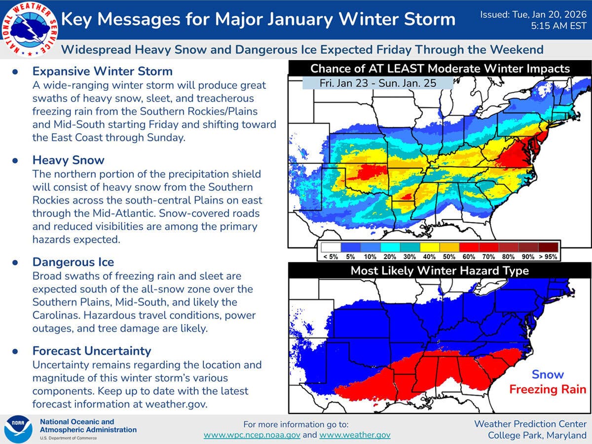
If you are traveling south this weekend, note that the National Weather Service is predicting freezing rain and sleet in the Southern Plains, Mid-South, and Carolinas. This could lead to hazardous travel, power outages and tree damage, according to the announcement.
“Uncertainty remains regarding the location and magnitude of this winter storm's various components,” the National Weather Service said.
WTNH is reporting there is an “increasing chance for a higher impact snow event for Sunday and Monday” in Connecticut.
“It is a long way out, but you need to pay attention as the trend overnight is for more snow coming our way!” WTNH’s Meteorologist Gil Simmons advises.
Very cold weather dominates the forecast
In the near term, today is going to be very cold with a daytime high near 23, and tonight the low will be in the single digits, according to the National Weather Service.
Both WTNH and the National Weather Service predict a chance for snow Wednesday night, followed by warmer temperatures on Thursday, with a high in the low 40s. Friday and Saturday are predicted to be cold and dry, with the big storm potentially beginning to impact the state very early Sunday.
Read More:
- Man Killed In Snowplowing Accident, ID Released: Police
- Local Teen Killed In Out-Of-State Crash, ID Released By State Police
- Man Shot While Trying To Break Up Fight At Business: Police
Here are the forecast details for southern Connecticut via the National Weather Service:
Tonight: Mostly clear, with a low around 10. West wind 5 to 8 mph.
Wednesday: A 20 percent chance of snow after 4pm. Increasing clouds, with a high near 37. Wind chill values between 5 and 15. Light west wind becoming southwest 5 to 10 mph in the morning.
Wednesday Night: A slight chance of rain and snow before 1am, then a slight chance of snow between 1am and 4am, then a slight chance of rain after 4am. Cloudy, then gradually becoming partly cloudy, with a low around 30. Southwest wind around 7 mph. Chance of precipitation is 20%.
Thursday: Mostly sunny, with a high near 42. Wind chill values between 25 and 35. Southwest wind 7 to 13 mph, with gusts as high as 23 mph.
Thursday Night: Mostly cloudy, with a low around 24. West wind around 7 mph.
Friday: Partly sunny, with a high near 32.
Friday Night: Partly cloudy, with a low around 7.
Saturday: Mostly sunny and cold, with a high near 17.
Saturday Night: A 40 percent chance of snow after 1am. Mostly cloudy, with a low around 8.
Sunday: A 50 percent chance of snow. Cloudy and cold, with a high near 20.
Sunday Night: A 50 percent chance of snow. Mostly cloudy, with a low around 11.
Monday: A 30 percent chance of snow. Partly sunny, with a high near 24.
Here are the forecast details for northern Connecticut via the National Weather Service:
Tonight: Mostly clear, with a low around 4. West wind around 6 mph becoming light and variable in the evening.
Wednesday: Increasing clouds, with a high near 32. Wind chill values as low as -2. Light south wind increasing to 5 to 10 mph in the morning. Winds could gust as high as 21 mph.
Wednesday Night: A chance of snow, mainly before 4am. Cloudy, then gradually becoming partly cloudy, with a low around 24. South wind around 9 mph, with gusts as high as 20 mph. Chance of precipitation is 30%. New snow accumulation of less than a half inch possible.
Thursday: A slight chance of snow before 8am. Mostly sunny, with a high near 42. Southwest wind 8 to 14 mph, with gusts as high as 31 mph. Chance of precipitation is 20%.
Thursday Night: Partly cloudy, with a low around 20. West wind 5 to 7 mph, with gusts as high as 22 mph.
Friday: Partly sunny, with a high near 28. West wind 6 to 13 mph, with gusts as high as 25 mph.
Friday Night: Partly cloudy, with a low around 3. Northwest wind around 10 mph, with gusts as high as 23 mph.
Saturday: Mostly sunny, with a high near 13. Northwest wind around 11 mph, with gusts as high as 21 mph.
Saturday Night: Mostly cloudy, with a low around 5. Northwest wind around 7 mph.
Sunday: A chance of snow. Mostly cloudy, with a high near 16. North wind 6 to 8 mph. Chance of precipitation is 50%.
Sunday Night: A chance of snow. Mostly cloudy, with a low around 8. North wind around 6 mph. Chance of precipitation is 50%.
Monday: A chance of snow. Partly sunny, with a high near 22. North wind 6 to 9 mph. Chance of precipitation is 30%.
Get more local news delivered straight to your inbox. Sign up for free Patch newsletters and alerts.