Weather
Expect Severe Thunderstorms During This 8-Hour Window In CT
Find out the latest forecast for the coming weekend, according to meteorologists.

The hot and humid weather continues today, with highs in the mid-90s and another chance for thunderstorms.
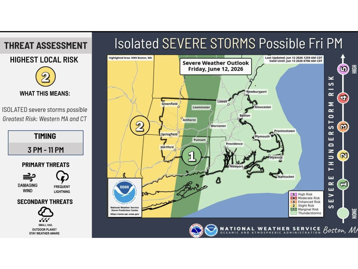
The National Weather Service says “strong to severe” thunderstorms with damaging winds are possible Friday afternoon and evening. It anticipates the best chance for a thunderstorm will be between 3 p.m. and 11 p.m.
WFSB reports storms will be possible this afternoon between about 3 p.m. and 7 p.m. in advance of a cold front.
Find out what's happening in Across Connecticutfor free with the latest updates from Patch.
“It looks like any that pop up will be isolated, but capable of becoming strong-to-severe,” WFSB reports. “Damaging wind gusts, hail, heavy rain and frequent lightning are possible.”
WTNH says today could bring scattered afternoon and evening thunderstorms, and some could be “severe, with strong wind gusts, hail and torrential rain.”
Find out what's happening in Across Connecticutfor free with the latest updates from Patch.
WTNH predicts any evening storms will move out by 9 to 10 p.m. tonight, followed by less humidity for the weekend.
A heat advisory remains in effect until 8 p.m. tonight, with heat index values reaching up to 101 degrees. An air quality alert is also in effect between 11 a.m. and 11 p.m. today in southern parts of Connecticut due to ground level ozone.
WFSB is calling Friday a “First Alert Weather Day” due to the “dangerous combination of heat and humidity.
“This afternoon could be worse than yesterday as temperatures will reach near-record levels pushing the heat index value near or over 100!” WFSB reports.
Read More:
- 81-Year-Old Arrested In Vandalism Case: Police
- ICE Arrests Man During Operation That Left 1-Year-Old Alone In Vehicle
- Road-Rage Crash Left Motorcyclist Seriously Injured, 2 Charged: Police
Weekend outlook
The National Weather Service is predicting Saturday will be dry and sunny with daytime highs reaching the upper 80s.
Sunday will be mostly sunny and hot, with highs around 90, followed by possible showers and thunderstorms Sunday evening, according to the National Weather Service.
WFSB reports humidity will drop for the weekend, though it will remain hot.
“While Saturday is dry and bright, cloud cover overspreads the state Sunday in advance of a cold front,” WFSB reports. “Provided this, it won’t be *as* warm on Sunday. As the front gets closer, the likelihood increases for showers and storms toward/after sunset.”
WTNH says both Saturday and Sunday are “looking great for all outdoor events!” as it will be mostly dry and less humid, though it also predicts showers and storms are possible again on Sunday night.
Here are the forecast details for northern Connecticut via the National Weather Service:
Today: A slight chance of showers, then a chance of showers and thunderstorms after 11 a.m. Mostly sunny and hot, with a high near 95. Heat index values as high as 101. Calm wind becoming west 5 to 7 mph in the afternoon. Chance of precipitation is 30%.
Tonight: A chance of showers and thunderstorms, mainly before 7 p.m. Partly cloudy, with a low around 64. Northwest wind 6 to 10 mph, with gusts as high as 20 mph. Chance of precipitation is 30%.
Saturday: Sunny, with a high near 89. Northwest wind 8 to 11 mph.
Saturday Night: Mostly clear, with a low around 61. Northwest wind 5 to 7 mph becoming calm in the evening.
Sunday: Mostly sunny and hot, with a high near 91. Light south wind increasing to 12 to 17 mph in the morning. Winds could gust as high as 29 mph.
Sunday Night: Showers and thunderstorms before 1 a.m., then showers likely and possibly a thunderstorm between 1 a.m. and 2 a.m., then a chance of showers after 2 a.m. Low around 61. South wind 9 to 15 mph becoming west after midnight. Winds could gust as high as 28 mph. Chance of precipitation is 90%.
Here are the forecast details for southern Connecticut via the National Weather Service:
Today: A slight chance of showers between 2 p.m. and 5 p.m., then a chance of showers and thunderstorms after 5 p.m. Mostly sunny, with a high near 93. Heat index values as high as 99. West wind 5 to 8 mph. Chance of precipitation is 30%.
Tonight: A chance of showers and thunderstorms before 8 p.m., then a chance of showers between 8 p.m. and 11 p.m. Mostly cloudy, with a low around 66. Northwest wind around 7 mph. Chance of precipitation is 30%.
Saturday: Sunny, with a high near 89. West wind 6 to 8 mph.
Saturday Night: Mostly clear, with a low around 65. Light west wind.
Sunday: A 20 percent chance of showers after 2 p.m. Partly sunny, with a high near 88. Light south wind increasing to 9 to 14 mph in the morning.
Sunday Night: Showers, mainly between 8 p.m. and 2 a.m. Low around 60. Chance of precipitation is 80%. New precipitation amounts between a tenth and quarter of an inch possible.
Get more local news delivered straight to your inbox. Sign up for free Patch newsletters and alerts.