Weather
Hazardous Weather Outlook Issued, New Snow Details Released For CT
Meteorologists are warning about dangerously cold temperatures in the days ahead.

Snow and frigid temperatures are in the forecast for Connecticut this week.
Meteorologists as of Wednesday are predicting light snow Friday night and into Saturday morning.
According to WTNH, a strong cold front comes through late Friday, bringing snow with it. WTNH’s prediction as of Wednesday is that it will only be a dusting to two inches of snow.
Find out what's happening in Across Connecticutfor free with the latest updates from Patch.
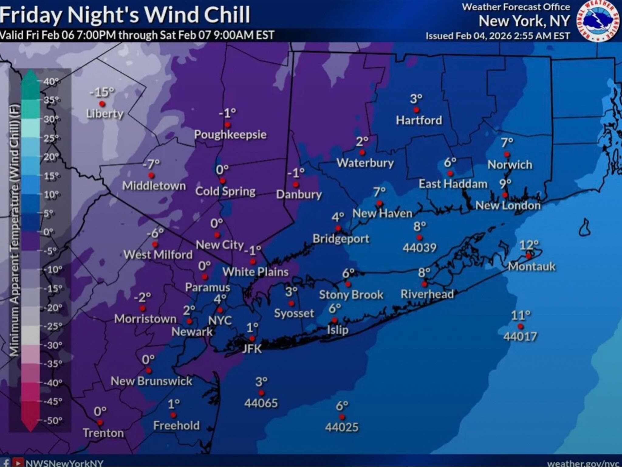
“More importantly, strong wind gusts and dangerously low wind chills are expected through much of the weekend! -10 to -35 wind chills at times!” WTNH meteorologists reported.
WFSB reports cloud cover will increase Friday “in advance of another clipper heading our way,” and the clipper will bring “minor” total snowfall.
Find out what's happening in Across Connecticutfor free with the latest updates from Patch.
“As it passes through the region there’s a chance for light snow at night, but as we see it now the impact will be minimal. Some minor accumulation (a coating to an inch) will be possible by Saturday morning,” WFSB reports.
WFSB is calling both Saturday and Sunday “First Alert Weather Days” due to the arctic temperatures and wind.
“Wind chill values will drop as the day goes on Saturday, ending up between -10 and -20 by the evening,” WFSB reports. “Sunday morning will feel even colder... more like it’s -15 to -30! By Sunday afternoon, as the wind weakens to a breeze, wind chill values will be between -5 and -15.”
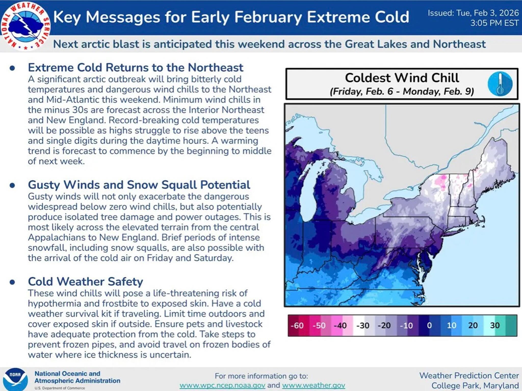
The National Weather Service has issued a hazardous weather outlook alert for Connecticut due to the anticipated frigid temperatures this weekend.
“An Arctic air mass combined with strong northwest winds may produce very cold to dangerous wind chills from Saturday night into Sunday morning,” the notice states. “Lowest wind chill values expected during the late night and early daylight hours, and could be as low as 15 to 20 below zero.”
Read More:
- Teacher Arrested, Placed On Leave, Officials Say
- Prominent Grocery Chain Files Plans To Open 1st Connecticut Location: Report
- Gov. Lamont Proposing One-Time Tax Rebate In CT
Gov. Ned Lamont has extended the state’s current Severe Cold Weather Protocol through at least noon on Tuesday, Feb. 10.
“We haven’t seen a stretch of temperatures this cold in over a decade,” Lamont said.
Lamont said shelters are available for anyone who needs to stay warm, and he urged residents to keep pets indoors.
Anyone in need of shelter or a warming center is urged to visit 211ct.org or call 2-1-1 to find available locations. Transportation can be provided.
Here are the forecast details for southern Connecticut via the National Weather Service:
Today: Partly sunny, then gradually becoming sunny, with a high near 31. Wind chill values between 20 and 25. Northwest wind 5 to 13 mph.
Tonight: Mostly clear, with a low around 10. Northwest wind around 6 mph becoming calm in the evening.
Thursday: Sunny, with a high near 31. Wind chill values between 5 and 15. North wind 3 to 6 mph.
Thursday Night: Partly cloudy, with a low around 10. Calm wind.
Friday: Partly sunny, with a high near 29. Calm wind becoming south around 5 mph.
Friday Night: Snow showers likely, mainly after 1 a.m. Mostly cloudy, with a low around 15. Chance of precipitation is 60%. New snow accumulation of less than a half inch possible.
Saturday: A 30 percent chance of snow showers before noon. Partly sunny, with a high near 26. Blustery.
Saturday Night: Mostly clear, with a low around 2.
Sunday: Mostly sunny and cold, with a high near 18.
Sunday Night: Partly cloudy, with a low around 5.
Here are the forecast details for northern Connecticut via the National Weather Service:
Today: Sunny, with a high near 31. Northwest wind 6 to 13 mph, with gusts as high as 24 mph.
Tonight: Patchy fog after 4 a.m. Otherwise, partly cloudy, with a low around 0. West wind around 5 mph becoming calm in the evening.
Thursday: Patchy fog before 9 a.m. Otherwise, sunny, with a high near 30. Wind chill values as low as zero. Calm wind becoming northwest around 6 mph in the morning.
Thursday Night: Partly cloudy, with a low around 2. Light north wind.
Friday: Partly sunny, with a high near 28. Calm wind becoming south around 5 mph in the afternoon.
Friday Night: Snow likely, mainly after 2 a.m. Mostly cloudy, with a low around 13. Calm wind becoming west around 5 mph after midnight. Chance of precipitation is 60%. Little or no snow accumulation expected.
Saturday: A chance of snow before 5 p.m. Partly sunny, with a high near 23. Blustery, with a northwest wind 13 to 22 mph, with gusts as high as 38 mph. Chance of precipitation is 50%.
Saturday Night: Mostly clear, with a low around -3. Blustery, with a northwest wind 15 to 21 mph, with gusts as high as 34 mph.
Sunday: Mostly sunny, with a high near 15. Northwest wind 10 to 14 mph, with gusts as high as 24 mph.
Sunday Night: Partly cloudy, with a low around -4. Northwest wind around 7 mph.
Get more local news delivered straight to your inbox. Sign up for free Patch newsletters and alerts.