Weather
Hazardous Weather Outlook Issued For Southern Connecticut
Find out when heavy rain and thunderstorms could impact the region, according to meteorologists.


A hazardous weather outlook has been issued for southern Connecticut Thursday due to the potential for showers and thunderstorms.
The alert is for southern Fairfield, New Haven and Middlesex counties for later today and tonight.
“Showers and potential thunderstorms are expected to move through the area this afternoon and evening,” the notice states. “A period of heavy rainfall is possible. At this time flash flooding is not expected, but can not be completely ruled out.”
Find out what's happening in Across Connecticutfor free with the latest updates from Patch.
In an update, the National Weather Service has issued a flood watch for all of Fairfield County until early Friday.
"A period of heavy rainfall is possible as showers and a few thunderstorms move through the area late this afternoon and evening. Peak hourly rainfall rates could reach 2 to 2.5 inches. Average rainfall amounts are expected to be between 1.5 and 2.5 inches with locally higher amounts possible," the weather service said concerning Fairfield County.
Find out what's happening in Across Connecticutfor free with the latest updates from Patch.
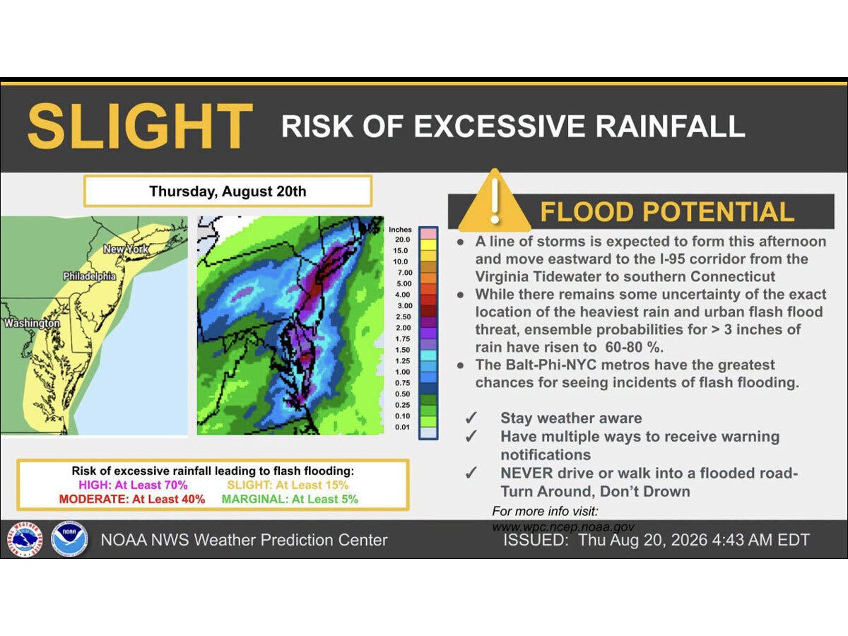
The National Weather Service advises that a line of storms is forecasted to bring heavy rainfall to the Interstate 95 corridor from Virginia to Connecticut this afternoon and evening.
WFSB is predicting an increase in cloudiness as today progresses, followed by “isolated” showers in the afternoon and evening, and a round of rain tonight. It anticipates showers will be lingering into Friday.
The National Weather Service predicts Friday will become partly sunny, with highs in the upper 70s.
Looking ahead to the weekend, it forecasts an 80 percent chance of showers on Saturday, and a 40 percent chance on Sunday.
“The upcoming weekend is a bit of a forecasting frustration (longer range model data is all over the place),” WFSB reports. “The issue: a pesky area of low pressure that will sit and spin nearby. As of now, Saturday is more unsettled. While not a washout, scattered showers are expected. Sunday is muggier and will feature isolated showers.”
Read More:
- 2 Killed As Dump Truck, SUV Collide On Major Highway
- Former Owners Of Car Dealership To Pay $4 Million In Penalties
Here are the forecast details for southern Connecticut via the National Weather Service:
Today: Showers, mainly after 5 p.m. High near 82. Light and variable wind becoming southwest around 6 mph in the afternoon. Chance of precipitation is 80%. New precipitation amounts between a quarter and half of an inch possible.
Tonight: Showers, mainly before 11 p.m. Low around 63. Northeast wind around 8 mph. Chance of precipitation is 80%. New precipitation amounts between 1 and 2 inches possible.
Friday: Partly sunny, with a high near 78. Northeast wind 8 to 10 mph.
Friday Night: A 50 percent chance of showers after 2 a.m. Mostly cloudy, with a low around 65. Northeast wind around 6 mph.
Saturday: Showers, mainly after 8 a.m. High near 76. Northeast wind 8 to 10 mph. Chance of precipitation is 80%. New precipitation amounts between three quarters and one inch possible.
Saturday Night: Showers. Low around 66. Chance of precipitation is 80%. New precipitation amounts between a tenth and quarter of an inch possible.
Sunday: A 40 percent chance of showers. Partly sunny, with a high near 81.
Sunday Night: Partly cloudy, with a low around 64.
Get more local news delivered straight to your inbox. Sign up for free Patch newsletters and alerts.