Weather
Hazardous Weather Outlook Issued, Strong-To-Severe Storms Emerge In Forecast For CT
Find out when heat, humidity and storms will be impacting the state, according to meteorologists.

A hazardous weather outlook has been issued for much of Connecticut due to soaring temperatures and humidity, and thunderstorms are also expected, according to meteorologists.
A heat advisory is in effect from noon Thursday through 8 p.m. on Friday, with heat index values in the mid to upper 90s, according to the National Weather Service.
The combination of hot temperatures and high humidity may cause heat-related illnesses, the National Weather Service advises. It recommends drinking plenty of fluids and staying in air conditioning when possible.
Find out what's happening in Across Connecticutfor free with the latest updates from Patch.
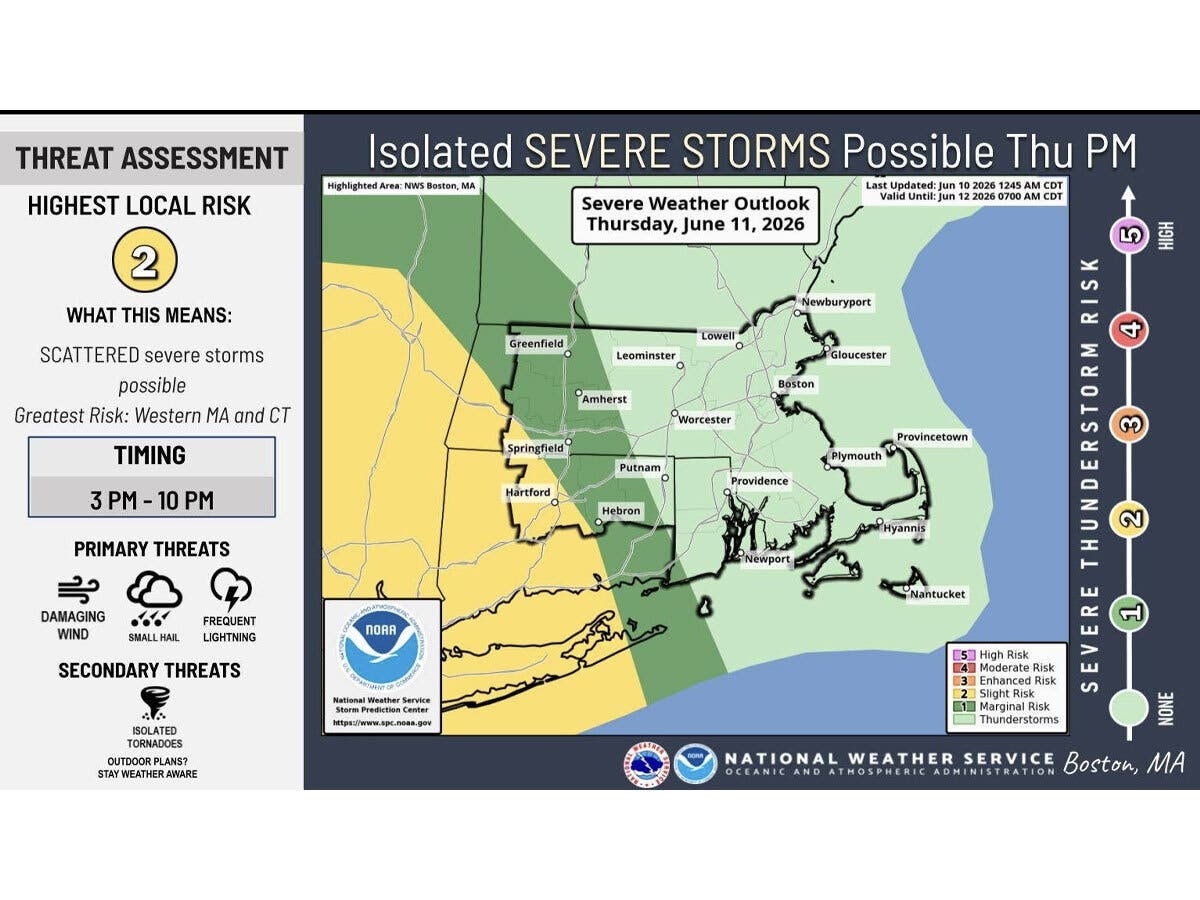
The National Weather Service said scattered severe thunderstorms are possible Thursday afternoon into the evening hours.
“The main risks will be strong, damaging winds along with hail. An isolated tornado cannot be completely ruled out at this time,” the National Weather Service said.
Find out what's happening in Across Connecticutfor free with the latest updates from Patch.
Thunderstorms are possible on Wednesday and Friday afternoons and evenings also, according to the National Weather Service.
WTNH reports the hot and humid weather will build today, followed by the heat advisory conditions starting on Thursday.
“Temperatures will climb well into the 80s and even 90s, with scattered afternoon/evening showers and thunderstorms Thursday and Friday,” WTNH reports.
WFSB predicts isolated afternoon and evening showers tonight, with muggier conditions.
WFSB is calling both Thursday and Friday “First Alert Weather Days” due to the high temperatures and humidity.
“The dangerous combination leads to heat index values reaching 95-100(+),” WFSB reports. “When it comes to the threat for storms, later Thursday (during the evening, toward sunset) appears to feature the greatest risk.”
Read More:
- 3 CT Children Died From Apparent Overdoses As Online Challenge Spreads
- Man Who Harassed, Threatened Police Rearrested, Put On Leave From Schools Job: Police
- 1 Dead, 1 Hospitalized After Suspected Domestic Violence Incident: PD
Here are the forecast details for northern Connecticut via the National Weather Service:
Today: Partly sunny, with a high near 85. South wind 6 to 13 mph.
Tonight: A chance of showers and thunderstorms, mainly between 8 p.m. and 2 a.m. Patchy fog after midnight. Otherwise, mostly cloudy, with a low around 67. South wind 5 to 10 mph, with gusts as high as 20 mph. Chance of precipitation is 50%.
Thursday: A slight chance of showers and thunderstorms after 2 p.m. Mostly sunny and hot, with a high near 94. Heat index values as high as 99. Light and variable wind becoming west 5 to 10 mph in the morning. Chance of precipitation is 20%.
Thursday Night: A chance of showers and thunderstorms. Mostly cloudy, with a low around 70. West wind around 6 mph becoming calm in the evening. Chance of precipitation is 30%. New precipitation amounts between a tenth and quarter of an inch, except higher amounts possible in thunderstorms.
Friday: A chance of showers, with thunderstorms also possible after 5 p.m. Partly sunny and hot, with a high near 95. Calm wind becoming southeast around 6 mph in the afternoon. Chance of precipitation is 30%.
Friday Night: Showers and thunderstorms likely before midnight, then a chance of showers. Mostly cloudy, with a low around 67. South wind 5 to 9 mph becoming west after midnight. Chance of precipitation is 60%.
Saturday: Sunny and hot, with a high near 92. Northwest wind 7 to 11 mph.
Here are the forecast details for southern Connecticut via the National Weather Service:
Today: Partly sunny, with a high near 77. South wind 6 to 10 mph.
Tonight: A 40 percent chance of showers and thunderstorms, mainly between 8 p.m. and 2 a.m. Mostly cloudy, with a low around 67. Southwest wind 5 to 8 mph.
Thursday: A 50 percent chance of showers and thunderstorms after 2 p.m. Partly sunny, with a high near 91. Heat index values as high as 98. West wind 5 to 10 mph.
Thursday Night: A 40 percent chance of showers and thunderstorms before 2 a.m. Mostly cloudy, with a low around 69. West wind 5 to 7 mph becoming calm in the evening.
Friday: A 20 percent chance of showers and thunderstorms after 2 p.m. Mostly sunny, with a high near 89. Calm wind becoming south 5 to 8 mph in the afternoon.
Friday Night: A chance of showers between 8 p.m. and 2 a.m. Mostly cloudy, with a low around 66. Chance of precipitation is 50%.
Saturday: Mostly sunny, with a high near 90.
Get more local news delivered straight to your inbox. Sign up for free Patch newsletters and alerts.