Weather
More Snow Now Forecast As Dangerous Weather Conditions Expected This Weekend In CT
Here are the new snow accumulation estimates and updates on bitterly cold temperatures this weekend.

Meteorologists are now predicting up to three inches of snow could fall in Connecticut this weekend, and the temperatures will be dangerously cold.
Find out what's happening in Across Connecticutfor free with the latest updates from Patch.
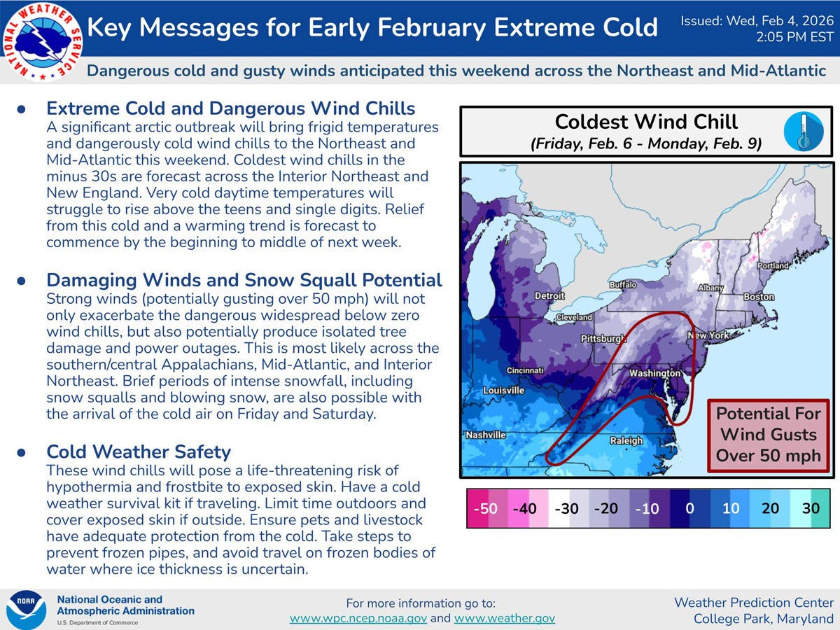
“In the wake of the front, the wind intensifies and the temperature drops,” WFSB meteorologists said. “The wind chill goes below zero toward and after sunset, thereafter it goes even lower.”
Feels like -30 this weekend
Find out what's happening in Across Connecticutfor free with the latest updates from Patch.
“Strong wind gusts and dangerously low wind chills are expected through much of the weekend! -10 to -35 wind chills at times, especially Saturday night-Sunday morning!” WTNH reports.
NBC Connecticut is also predicting a coating to two inches of “light, fluffy snow” late Friday night into Saturday, followed by “brutally cold temperatures” and “dangerous” wind chills.
Hazardous weather outlook issued
The National Weather Service has issued a hazardous weather outlook alert advising that an arctic air mass combined with strong northwest winds may produce “very cold to dangerous wind chills from late day Saturday into Sunday morning.”
“Lowest wind chill values expected during the late night and early daylight hours, and could be as low as 15 to 20 below zero,” the National Weather Service reports.
The National Weather Service advises that these wind chills could pose a life-threatening risk of hypothermia and frostbite to exposed skin.
Severe cold weather protocol is active
Connecticut’s current Severe Cold Weather Protocol is active through at least noon on Tuesday, Feb. 10. Shelters are available for anyone who needs to stay warm. Visit 211ct.org or call 2-1-1 to find available locations. Transportation can be provided.
Slightly warmer weather arrives with the work week, according to the National Weather Service. It predicts Monday and Tuesday will be warmer than the weekend, with sunny skies and daytime highs reaching the upper 20s to low 30s.
Read More:
- Majority Of Major Mall Ordered Closed: Here’s Why, What To Know
- 14 Train Cars Carrying Flammable Liquified Gas Derail, 5 Cars In River
- Firefighter Placed On Leave Amid Criminal Probe, Official Says
Here are the forecast details for southern Connecticut via the National Weather Service:
Today: Sunny, with a high near 30. Wind chill values between 15 and 25. Calm wind becoming northwest around 6 mph.
Tonight: Partly cloudy, with a low around 12. Calm wind.
Friday: Mostly cloudy, with a high near 28. Wind chill values between 15 and 25. Light and variable wind.
Friday Night: Snow likely, mainly after 1 a.m. Cloudy, with a low around 15. Calm wind. Chance of precipitation is 70%. New snow accumulation of less than a half inch possible.
Saturday: Snow likely, mainly before noon, then a slight chance of snow showers after 1 p.m. Mostly cloudy, with a temperature rising to near 22 by 10 a.m., then falling to around 13 during the remainder of the day. Blustery, with a northwest wind 7 to 12 mph increasing to 19 to 24 mph in the afternoon. Winds could gust as high as 38 mph. Chance of precipitation is 60%. New snow accumulation of less than one inch possible.
Saturday Night: Partly cloudy, with a low around 2. Blustery.
Sunday: Sunny and cold, with a high near 18.
Sunday Night: Mostly clear, with a low around 5.
Monday: Sunny, with a high near 26.
Monday Night: Mostly clear, with a low around 14.
Tuesday: Sunny, with a high near 32.
Here are the forecast details for northern Connecticut via the National Weather Service:
Today: Sunny, with a high near 29. Northwest wind 3 to 6 mph.
Tonight: Mostly cloudy, with a low around 3. North wind around 5 mph becoming calm in the evening.
Friday: Mostly cloudy, with a high near 27. Calm wind.
Friday Night: Snow likely, mainly after 3 a.m. Cloudy, with a low around 14. Calm wind. Chance of precipitation is 70%. Little or no snow accumulation expected.
Saturday: Snow likely, mainly before noon. Cloudy, with a high near 24. Blustery, with a northwest wind 7 to 12 mph increasing to 17 to 22 mph in the afternoon. Winds could gust as high as 36 mph. Chance of precipitation is 70%. Little or no snow accumulation expected.
Saturday Night: A slight chance of snow before 8 p.m. Partly cloudy, with a low around -3. Blustery, with a northwest wind 14 to 21 mph, with gusts as high as 34 mph. Chance of precipitation is 20%.
Sunday: Sunny, with a high near 16. Northwest wind 11 to 13 mph, with gusts as high as 25 mph.
Sunday Night: Mostly clear, with a low around -2. Northwest wind 6 to 8 mph.
Monday: Sunny, with a high near 25. Northwest wind 5 to 9 mph.
Monday Night: Mostly clear, with a low around 7. Northwest wind around 6 mph.
Tuesday: Sunny, with a high near 31. Northwest wind 5 to 7 mph.
Get more local news delivered straight to your inbox. Sign up for free Patch newsletters and alerts.