Seasonal & Holidays
Peak Autumn: Connecticut Foliage Is About To Get Real
Most areas of the state are just about one week away from peak fall foliage. Here are the best places to appreciate all the colors.

CONNECTICUT — Most areas of the state are just about one week away from peak fall foliage, so now is the time to make your plans to make some memories.
From Oct. 16 to Oct. 23, most of the state will be at the height, according to the Connecticut Department of Energy and Environmental Protection.
In the yellow-colored areas of the DEEP map below, the number of trees where the leaves have turned will be low. Bright red areas are in their peak, and the dark red northern corners of the state will be past their peak.
Find out what's happening in Across Connecticutfor free with the latest updates from Patch.
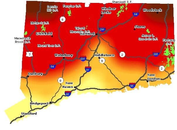
DEEP is recommending these nine locations for the foliage vantage points they offer:
- Macedonia Brook State Park, Kent – Cobble Mountain: From Kent Center, take Route 341 west for approximately 2 miles. Take first right onto Macedonia Brook Road, which takes you into the park. (Bear left at the fork.) Office and parking lot are located 1 mile inside the park. Trail maps are available. Take white blazed Cobble Mountain Trail. The overlook has views across the Harlem Valley to the Taconic and Catskill Mountains.
- Mohawk State Forest, Cornwall: From Torrington, Route 4W (14 miles) to forest entrance (Toumey Road) on left. Take road to ‘T’ intersection and turn right onto Mohawk Mountain Road. Scenic vistas to the north and west include the Catskill, Taconic and Berkshire ranges. For your hiking pleasure, both the Mattatuck and Mohawk trails (blue blazed) cross the site.
- Pachaug State Forest, Voluntown – Mt. Misery Overlook: From Voluntown take Route 49N (6 miles) to forest entrance on the left. Go west (2 miles) and bear left at forks to parking area. Take woods access road on left to overlook. This forest also contains miles of roads and hiking trails.
- Peoples State Forest, Barkhamsted – Chaugnam Lookout: From junction of Routes 318 and 181 in Pleasant Valley, go east over bridge then take first left onto East River Road. Jesse Gerard trailhead is 2.4 miles on the right. Recreation area is opposite the trailhead. Take trail (yellow blazes) to two lookouts.
- Shenipsit State Forest, Somers – Observation Tower: From Somers, Take Route 190E (1.25 miles) to blinking yellow light. Turn right onto Gulf Road (2.25 miles) to next right after Mountain View Road, which is Soapstone Mountain Road. Take road to tower parking lot. For your hiking enjoyment, Shenipsit Trail (blue blazed) runs by the tower. The observation tower on Soapstone Mountain provides wonderful views of the surrounding and distant landscapes.
- Talcott Mountain State Park, Simsbury – Heublein Tower: From Bloomfield, take Route 185W (3 miles) to entrance sign on left after mountain crest.Park along the road near the trailhead. Hike to ridge, then left to the restored Heublein tower. View from tower is over the Farmington River Valley.Another nearby alternative is located at Penwood State Park (entrance is on left 500 feet east from Talcott Mountain entrance). From the parking lot, a hike up the gated road loops to an escarpment overlook.
- Mt. Tom State Park, Litchfield: Located off Route 202 – A stone tower 1, 325 feet above sea level can be reached by hiking a one-mile long trail.
- Dennis Hill State Park, Norfolk: Located off Route 272 – A summit pavilion located 1, 627 feet above sea level provides views of New Hampshire, Vermont’s Green Mountains, and more. The drive to the summit is open weekends only from October 4 through October 26.
- Goodwin Conservation Center, On Route 6 in Hampton: View autumn colors reflected in the water of Pine Acres Pond from the wildlife-watching platform (wheelchair accessible). You can also walk through the canopy along one section of the Air Line Trail in the Goodwin State Forest.
As "leaf peeping" is sort of a Big Connecticut Thing, the State Tourism Office has numerous resources to assist you in your autumn adventure. Not least among these is the DEEP State Parks and Forests Maps page. You can also find trails suggested for your activity or trails located near you by using DEEP’s interactive 'Find a State Park or Forest' map. Located throughout Connecticut, the trails bring visitors along lakes, streams, rivers, ridgelines, and forests where they can quietly enjoy nature at their own pace.
Find out what's happening in Across Connecticutfor free with the latest updates from Patch.
If you're in the mood for a longer road trip than just Simsbury or Voluntown, let the Fall Foliage Prediction Map from SmokyMountains.com be your guide.
Credit: SmokyMountains.com
To use the map, simply slide the scale to the right to see when leaves will peak in your area of interest. Areas shaded in green have not begun to change color. As the season progresses, the map shows a progression of colors. When areas are shaded in brown, the leaves are past their peak. Zero in on the richest reds to find the county to book your Airbnb.
Get more local news delivered straight to your inbox. Sign up for free Patch newsletters and alerts.