Weather
Powerful Nor'easter Storm: Here Are The Impacts We'll See In CT
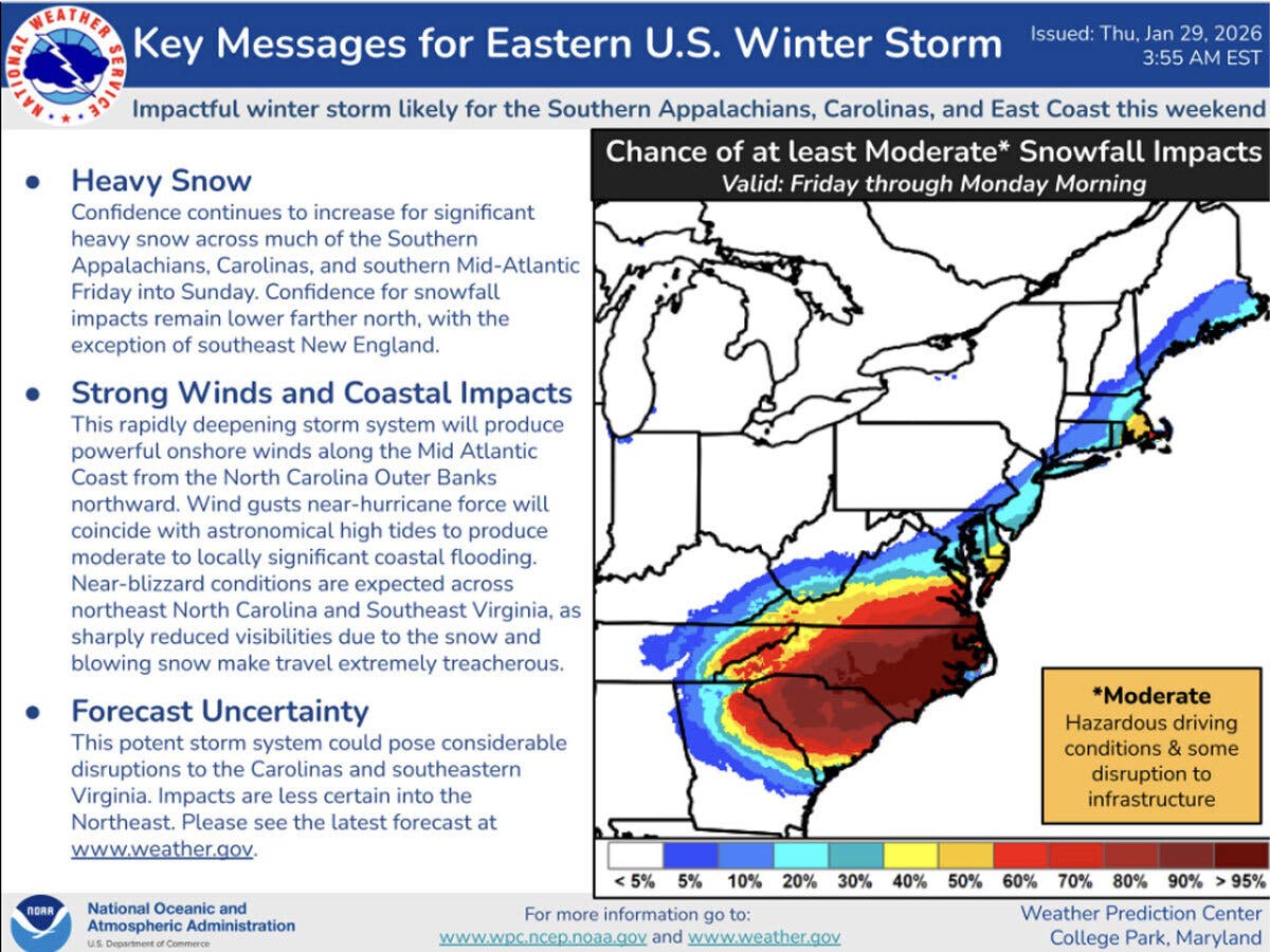
A strong nor'easter storm will head to New England this weekend and here are new details on what impacts we'll see.

In an update Thursday, the National Weather Service said, "Accumulating snow potential is decreasing on Sunday with the highest chance across eastern Long Island and southeast Connecticut."
A snow map shared by the weather service shows 1.3 inches of snow in New London County and around a half inch of snow for the remainder of southern Connecticut. North winds 15-25 mph with gusts 35-45 mph possible, mainly near the coast on Sunday, the weather service said.
In northern Connecticut, the chance for any snow Sunday is down to 30 percent, and if any snow does fall, little to no accumulation is expected, according to the weather service.
Find out what's happening in Across Connecticutfor free with the latest updates from Patch.
If the snow misses us for the most part, no snow is in the forecast through next Wednesday, though there is a chance for snow on Thursday, according to the weather service. Daytime high temperatures won't reach 32 degrees for another week at least.
Original story: A powerful nor’easter is most likely to impact eastern Connecticut on Sunday, while western parts of the state could be spared, according to meteorologists.
Find out what's happening in Across Connecticutfor free with the latest updates from Patch.
According to WTNH, two out of three forecast models are showing the storm will be “mostly a miss” for Connecticut.
“We all need to closely watch the trend through the rest of this week as any shift could dramatically impact the entire state with heavy snow amounts, power outage winds, and coastal flooding or miss the state completely!” WTNH reports.
Even if the storm goes out to sea, wind and coastal flooding could still be an issue for Connecticut, according to WTNH.
WFSB is calling Sunday a First Alert Weather Day and reports there is “growing confidence” there will be some storm impact on Sunday.
“The track of the storm appears to favor a brushing of Southern New England, to the point (east/southeast Connecticut) could receive measurable snow,” WFSB reports. “A shift farther east would lead to a complete miss for CT. Conversely, a shift west = greater impact, on multiple fronts.”
The National Weather Service has a hazardous weather outlook alert for southern Connecticut for Sunday. It says the coastal storm may come close enough to bring accumulating snowfall. It puts the chance of snow on Sunday in Connecticut around 40 percent.
NBC Connecticut is predicting the Sunday storm will give the state a “glancing blow,” with a chance of snow in eastern Connecticut.
None of the stations are giving estimates for snowfall totals as of Thursday morning.
Read More:
- ’Problematic’ Sexual Activities Investigated At State Office Building, Officials Say
- Mayor Issues Statement After ICE Agents Seen In Town
- CT Treasurer: $1B Is Waiting To Be Claimed
In the short term, it is expected to stay brutally cold, and the National Weather Service has a cold weather advisory for most of southern New England. It is warning of the potential for hypothermia or frostbite.
Today’s high temperatures will be in the low 20s, while tonight will dip down to below zero in northern parts of the state. Friday’s daytime temperatures will reach into the teens, while the weekend highs will only be in the 20s, according to the National Weather Service.
Here are the forecast details for northern Connecticut via the National Weather Service:
Today: Mostly sunny, with a high near 21. Wind chill values as low as -1. Calm wind becoming northwest 5 to 9 mph in the afternoon.
Tonight: Mostly clear, with a low around -2. Wind chill values as low as -13. West wind 7 to 9 mph.
Friday: Sunny, with a high near 14. Wind chill values as low as -15. West wind 8 to 13 mph.
Friday Night: Mostly clear, with a low around -6. West wind around 6 mph becoming calm after midnight.
Saturday: Sunny, with a high near 20. Calm wind becoming north around 6 mph in the afternoon.
Saturday Night: A slight chance of snow after 3 a.m. Mostly cloudy, with a low around 4. North wind 5 to 13 mph. Chance of precipitation is 20%.
Sunday: A chance of snow after 8 a.m. Mostly cloudy, with a high near 24. North wind 14 to 17 mph, with gusts as high as 31 mph. Chance of precipitation is 40%.
Sunday Night: A chance of snow before 9 p.m. Mostly cloudy, with a low around 9. Northwest wind 13 to 15 mph, with gusts as high as 29 mph. Chance of precipitation is 30%.
Here are the forecast details for southern Connecticut via the National Weather Service:
Today: Sunny, with a high near 22. Wind chill values between zero and 10. Northwest wind 7 to 10 mph.
Tonight: Mostly clear, with a low around 7. Wind chill values between zero and 5. West wind around 7 mph.
Friday: Sunny and cold, with a high near 18. Wind chill values between -5 and 5. West wind 7 to 11 mph.
Friday Night: Mostly clear, with a low around 3. Northwest wind 3 to 7 mph.
Saturday: Mostly sunny, with a high near 21. Northwest wind 3 to 6 mph.
Saturday Night: A 30 percent chance of snow after 1 a.m. Mostly cloudy, with a low around 9.
Sunday: A 40 percent chance of snow. Cloudy, with a high near 25.
Sunday Night: Mostly cloudy, with a low around 15.
Get more local news delivered straight to your inbox. Sign up for free Patch newsletters and alerts.