Weather
Severe Thunderstorms Forecast In CT: Here’s When, What To Expect
Find out the latest timing for potential storms in Connecticut, and the weather for the week ahead.


Today is expected to be sunny, with highs around 80, then the next chance for severe weather arrives on Tuesday, according to meteorologists.
The National Weather Service reports another storm system brings a risk for scattered severe thunderstorms Tuesday afternoon and into the evening.
Wind damage is the primary risk from the system, and torrential rain could cause street flooding, the National Weather Service reports.
Find out what's happening in Across Connecticutfor free with the latest updates from Patch.
Timeline for storms
It predicts the likeliest timeframe for storms will be between 4 p.m. Tuesday and 4 a.m. Wednesday.
Find out what's happening in Across Connecticutfor free with the latest updates from Patch.
The chance for precipitation is at its highest Tuesday night, or around 90 percent, though the chance for showers and thunderstorms continues into Wednesday.
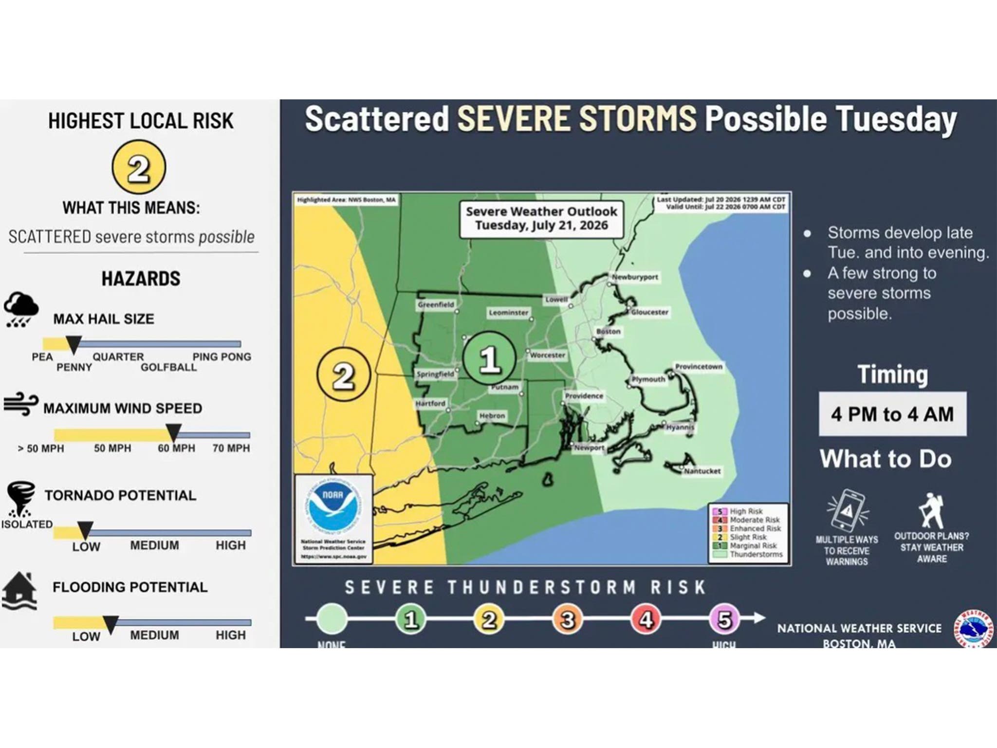
WFSB reports a disturbance arrives Tuesday and will impact Connecticut into Wednesday, “bringing rounds of rain and storms.”
“The greatest coverage and most concerning round arrives (Tuesday) afternoon and into the evening,” WFSB reports. “While a strong or severe wind producing storm is possible, the greater concern has to do with heavy rainfall resulting in flooding. Widely scattered afternoon storms are possible on Wednesday, and a strong storm can’t be ruled out.”
WFSB is calling both Tuesday and Wednesday “First Alert Weather Days” because of the potential impact on travel and outdoor activities.
WTNH also predicts showers and storms will return to Connecticut on Tuesday, and its forecasters say some storms could be severe.
“We will be watching for the risk of a strong storm or two,” WTNH reports. “A brief shower or storm Wednesday before quiet weather returns for the end of this week.”
The National Weather Service is predicting sunny days on both Thursday and Friday, with highs in the low to mid 80s.
Read More:
- Major Layoffs At TV News Station Announced: Reports
- Popular Family Restaurant To Close As Owner Plans To Open New Eatery Elsewhere
- Unique Donut Shop Permanently Closes, Owner Announces
Here are the forecast details for northern Connecticut via the National Weather Service:
Today: Sunny, with a high near 82. Calm wind becoming southwest 5 to 7 mph in the afternoon.
Tonight: Increasing clouds, with a low around 59. South wind 5 to 7 mph.
Tuesday: A chance of showers, then showers likely and possibly a thunderstorm after 3 p.m. Mostly cloudy, with a high near 80. South wind 7 to 14 mph, with gusts as high as 24 mph. Chance of precipitation is 60%. New rainfall amounts between a tenth and quarter of an inch, except higher amounts possible in thunderstorms.
Tuesday Night: Showers and possibly a thunderstorm. Low around 65. Southeast wind 7 to 9 mph. Chance of precipitation is 90%. New rainfall amounts between a quarter and half of an inch possible.
Wednesday: A chance of showers and thunderstorms, then showers likely and possibly a thunderstorm after 2 p.m. Partly sunny, with a high near 84. Southwest wind 8 to 13 mph. Chance of precipitation is 60%.
Wednesday Night: A chance of showers and thunderstorms before 8 p.m. Mostly clear, with a low around 57. Northwest wind 5 to 8 mph. Chance of precipitation is 30%.
Thursday: Sunny, with a high near 80. Northwest wind 3 to 6 mph.
Thursday Night: Mostly clear, with a low around 57. Light and variable wind.
Friday: Sunny, with a high near 84. Calm wind.
Here are the forecast details for southern Connecticut via the National Weather Service:
Today: Sunny, with a high near 80. Calm wind becoming south 5 to 7 mph in the afternoon.
Tonight: Increasing clouds, with a low around 68. South wind 5 to 7 mph.
Tuesday: Showers likely and possibly a thunderstorm, mainly after 2 p.m. Mostly cloudy, with a high near 78. Southeast wind 9 to 14 mph. Chance of precipitation is 70%. New rainfall amounts between a half and three quarters of an inch possible.
Tuesday Night: Showers and possibly a thunderstorm. Low around 70. South wind around 9 mph. Chance of precipitation is 90%. New rainfall amounts between a quarter and half of an inch possible.
Wednesday: Showers likely and possibly a thunderstorm before 8 a.m., then a chance of showers and thunderstorms after 8 a.m. Partly sunny, with a high near 81. Southwest wind 9 to 11 mph. Chance of precipitation is 60%.
Wednesday Night: Partly cloudy, with a low around 63.
Thursday: Sunny, with a high near 82.
Thursday Night: Mostly clear, with a low around 62.
Friday: Sunny, with a high near 77.
Get more local news delivered straight to your inbox. Sign up for free Patch newsletters and alerts.