Weather
Severe Thunderstorm Warning Issued For Most Of Southern Connecticut
Gov. Ned Lamont has activated an extreme hot weather protocol through the weekend.

The National Weather Service in Upton NY has issued a Severe Thunderstorm Warning for Central Fairfield County and Southwestern New Haven County until 5:30 p.m.
At 4:49 PM EDT, a severe thunderstorm was located over Monroe, or near Shelton, moving southeast at 25 mph.
HAZARD...60 mph wind gusts and quarter size hail.
Find out what's happening in Across Connecticutfor free with the latest updates from Patch.
IMPACT...Minor hail damage to vehicles is possible. Expect wind damage to trees and power lines.
This severe thunderstorm will be near...
Find out what's happening in Across Connecticutfor free with the latest updates from Patch.
- Shelton and Seymour around 455 PM EDT.
- Milford around 500 PM EDT.
- New Haven and Stratford around 505 PM EDT.
- Meriden and Wallingford around 430 PM EDT.
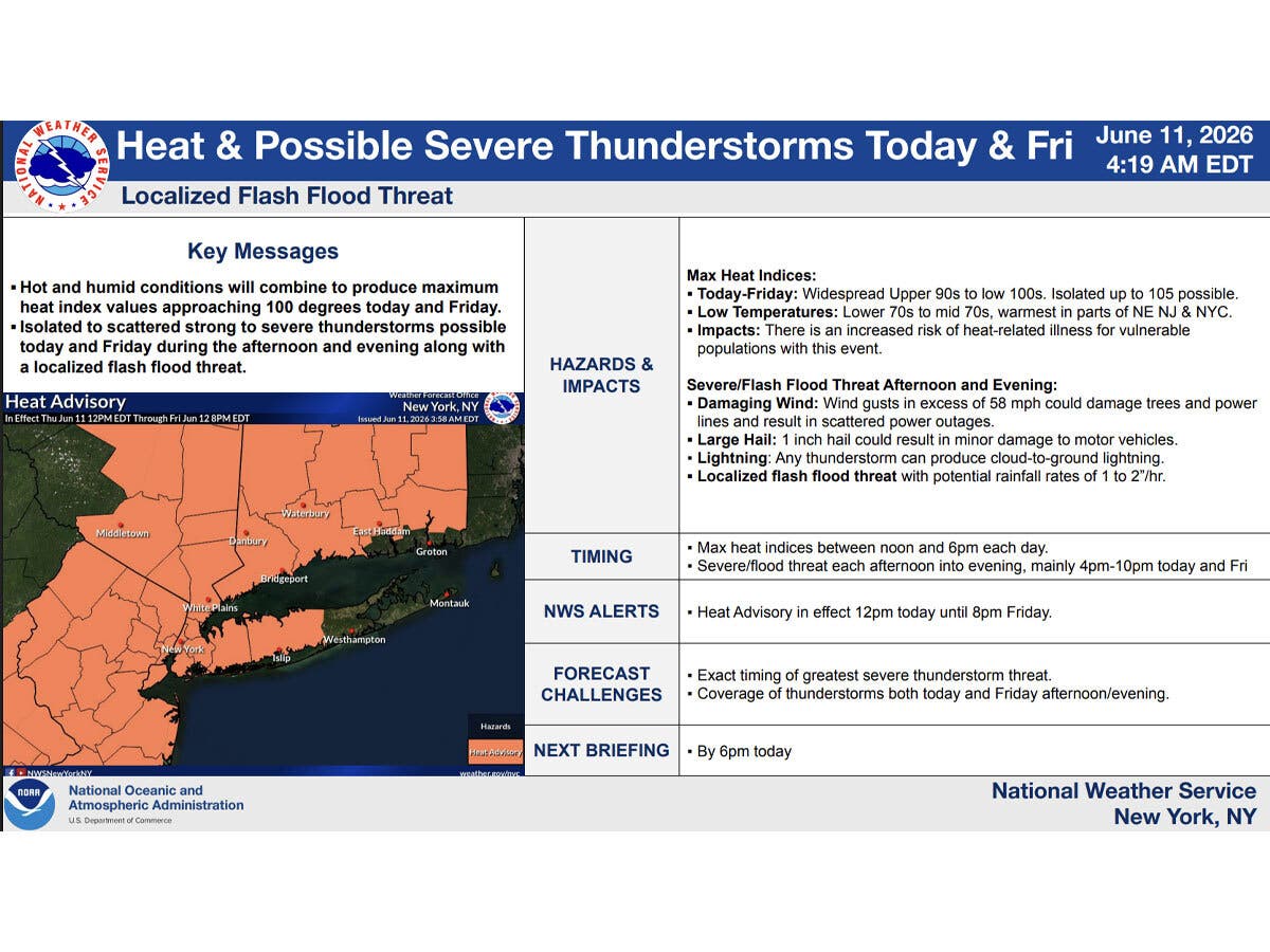
It will be hot and humid in Connecticut today and Friday, with severe thunderstorms possible, according to the National Weather Service.
Isolated strong to severe thunderstorms with damaging winds are possible Thursday afternoon and evening, primarily in western Connecticut. Other areas of the state could also get thunderstorms, with hazards limited to lightning and downpours, according to the National Weather Service.
Thunderstorms are most likely to occur after 3 p.m. today.
Scattered severe thunderstorms are also possible Friday afternoon into the evening, primarily in western Connecticut, with the potential for strong damaging winds and hail, the National Weather Service said.
Heat advisories are in effect from noon today through 8 p.m. Friday, with heat index values up to 100 degrees expected. High temperatures today and tomorrow will reach the low to mid-90s, according to the National Weather Service.
An air quality alert is in effect from 11 a.m. to 11 p.m. Thursday along the Connecticut coast due to ground level ozone.
WFSB is calling today and tomorrow “First Alert Weather Days” due to the “dangerous combo of heat and humidity” and the chance for strong to severe storms.
For today, WFSB says it is monitoring storms that develop to the west and head toward Connecticut.
“An isolated storm or two could pop up during the afternoon. It’s during the evening, toward sunset, that we expect the greatest risk,” WFSB reports. “In stronger storms a gusty/damaging wind will be possible, in addition to heavy rain and frequent lightning.”
For Friday, WFSB says it is expecting a similar scenario.
“We’ll start dry and bright, then by evening, storms will be possible in advance of a cold front heading our way,” WFSB reports.
Read More:
- Student Dies After Drowning
- Schools' Employee Struck Child, 6: PD
- Burglars Hit Over 40 Fire-Damaged Apartments, Police Say
Due to the heat wave, Gov. Ned Lamont has directed the state’s Extreme Hot Weather Protocol to be activated between 10 a.m. today until 6 p.m. on Sunday.
The combined high heat and humidity could cause heat-related illnesses, and residents are advised to seek air conditioning, according to the National Weather Service.
Cooling centers will be available throughout Connecticut. Find a cooling center near you by visiting www.211ct.org or calling 2-1-1.
“This protocol helps ensure that everyone has access to a safe place to stay cool and get relief from the extremely hot and humid conditions outside,” Lamont said.
Here are the forecast details for northern Connecticut via the National Weather Service:
Today: A slight chance of showers and thunderstorms after 3 p.m. Mostly sunny and hot, with a high near 93. Heat index values as high as 99. Light west wind becoming northwest 5 to 10 mph in the morning. Chance of precipitation is 20%.
Tonight: A chance of showers and thunderstorms, mainly before 10 p.m. Partly cloudy, with a low around 71. West wind around 6 mph becoming calm in the evening. Chance of precipitation is 30%. New precipitation amounts of less than a tenth of an inch, except higher amounts possible in thunderstorms.
Friday: Mostly sunny and hot, with a high near 95. Heat index values as high as 102. Calm wind becoming west around 6 mph in the afternoon.
Friday Night: Showers and thunderstorms likely, mainly before midnight. Mostly cloudy, then gradually becoming mostly clear, with a low around 64. Southwest wind 6 to 9 mph becoming northwest in the evening. Chance of precipitation is 60%. New rainfall amounts between a tenth and quarter of an inch, except higher amounts possible in thunderstorms.
Saturday: Sunny and hot, with a high near 90. Northwest wind 7 to 11 mph.
Saturday Night: Mostly clear, with a low around 62. West wind 5 to 7 mph becoming calm in the evening.
Sunday: Mostly sunny and hot, with a high near 92. Light south wind increasing to 11 to 16 mph in the morning. Winds could gust as high as 26 mph.
Here are the forecast details for southern Connecticut via the National Weather Service:
Today: A chance of thunderstorms after 5 p.m. Partly sunny, with a high near 92. Heat index values as high as 100. West wind 3 to 8 mph. Chance of precipitation is 30%.
Tonight: A chance of showers and thunderstorms before 11 p.m., then a chance of showers between 11 p.m. and 2 a.m. Mostly cloudy, with a low around 69. West wind around 5 mph becoming calm in the evening. Chance of precipitation is 40%.
Friday: A chance of thunderstorms after 5 p.m. Mostly sunny, with a high near 91. Heat index values as high as 99. Calm wind becoming southwest 5 to 7 mph in the afternoon. Chance of precipitation is 30%.
Friday Night: A 50 percent chance of showers and thunderstorms before 2 a.m. Mostly cloudy, with a low around 67. Light and variable wind becoming northwest 5 to 7 mph after midnight.
Saturday: Sunny, with a high near 89. Northwest wind 7 to 9 mph.
Saturday Night: Mostly clear, with a low around 65.
Sunday: Mostly sunny, with a high near 91.
Get more local news delivered straight to your inbox. Sign up for free Patch newsletters and alerts.