Weather
‘Significant Snowfall’ Possible For Parts Of CT As Major Coastal Storm Emerges In Forecast, NWS Says
Here are new details on a major storm and the latest on how close it will track to Connecticut.

A coastal storm may come close enough to bring “significant snowfall” in Connecticut on Sunday, according to meteorologists.
The National Weather Service on Wednesday morning issued a hazardous weather outlook notice for southern Connecticut about the weekend’s weather.
“A coastal storm will develop off the (southeast) coast and may come close enough to bring a significant snowfall to eastern portions of the region during the second half of the weekend,” the notice states.
Find out what's happening in Across Connecticutfor free with the latest updates from Patch.
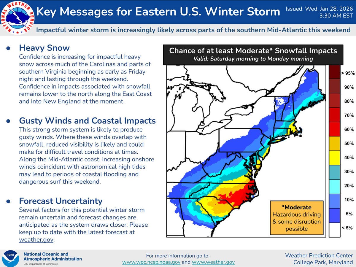
The National Weather Service’s Weather Prediction Center announced today that a winter storm is likely this weekend, though there is still uncertainty about the local impact.
“Confidence has increased, particularly across the Carolinas and southern Virginia, for impactful snowfall beginning as early as Friday night,” the center said. “Gusty winds and coastal impacts are also possible along the Mid-Atlantic. Currently, more uncertainty remains for areas north along the East Coast.”
Find out what's happening in Across Connecticutfor free with the latest updates from Patch.
As of Wednesday morning, the National Weather Service’s forecast predicts a 40 percent chance of snow in Connecticut on Sunday.
The National Weather Service urged residents to keep monitoring the forecast this week, as “several factors for this potential winter storm remain uncertain.”
WTNH is reporting the storm could impact Connecticut on Sunday and Sunday night.
“As of now, eastern Connecticut would have a high impact snow event and not much at all for western Connecticut,” WTNH reports.
However, the station reports the models are not in agreement currently, and the storm could miss Connecticut and go out to sea.
“We all need to watch the trend through the rest of this week as any shift could dramatically impact the entire state with heavy snow amounts, power outage winds and coastal flooding,” WTNH reports.
WFSB reported Wednesday that recent forecast models show the storm could “brush the southeastern portion of the state on Sunday.”
Meteorologist Scot Haney reported, “There’s going to be a storm…whether it tracks close to Connecticut or not remains to be seen.”
Read More:
- Beloved Historic Restaurant Destroyed In Fire, ‘The Loss Is Heartbreaking For Everyone’
- Woman Accused Of Threatening, Pointing Gun At Neighbors: Police
- Crews Battle Frozen Hoses, Intense Flames As Raging Fire Destroys Home
Here are the forecast details for northern Connecticut via the National Weather Service:
Today: Increasing clouds, with a high near 22. Wind chill values as low as -2. Southwest wind 5 to 8 mph becoming northwest in the afternoon.
Tonight: Mostly cloudy, with a low around 2. Wind chill values as low as -5. Calm wind becoming northwest around 5 mph after midnight.
Thursday: Mostly sunny, with a high near 21. Wind chill values as low as -3. Light west wind becoming northwest 5 to 10 mph in the morning.
Thursday Night: Mostly clear, with a low around 0. Wind chill values as low as -12. West wind around 7 mph, with gusts as high as 20 mph.
Friday: Sunny, with a high near 15. West wind 7 to 11 mph, with gusts as high as 26 mph.
Friday Night: Mostly clear, with a low around -7. West wind around 6 mph becoming calm after midnight.
Saturday: Sunny, with a high near 19. Calm wind becoming north around 6 mph in the afternoon.
Saturday Night: Mostly cloudy, with a low around 8. North wind 6 to 13 mph.
Sunday: A chance of snow after 9 a.m. Mostly cloudy, with a high near 25. North wind 14 to 16 mph, with gusts as high as 29 mph. Chance of precipitation is 40%.
Sunday Night: A chance of snow before 11 p.m. Mostly cloudy, with a low around 14. Northwest wind 13 to 15 mph, with gusts as high as 26 mph. Chance of precipitation is 30%.
Here are the forecast details for southern Connecticut via the National Weather Service:
Today: Increasing clouds, with a high near 24. Wind chill values between 5 and 15. Northwest wind 5 to 7 mph.
Tonight: Mostly cloudy, with a low around 6. Wind chill values between zero and 5. Northwest wind 5 to 7 mph.
Thursday: Sunny, with a high near 23. Wind chill values between -5 and 5. Northwest wind 7 to 10 mph.
Thursday Night: Mostly clear, with a low around 5. Wind chill values between -5 and zero. West wind around 7 mph.
Friday: Sunny and cold, with a high near 20. West wind 6 to 10 mph.
Friday Night: Mostly clear, with a low around 2.
Saturday: Mostly sunny, with a high near 21.
Saturday Night: A 30 percent chance of snow after 1 a.m. Mostly cloudy, with a low around 12.
Sunday: A 40 percent chance of snow. Mostly cloudy, with a high near 27.
Sunday Night: A 30 percent chance of snow before 1 a.m. Mostly cloudy, with a low around 16.
Get more local news delivered straight to your inbox. Sign up for free Patch newsletters and alerts.