Traffic & Transit
State Of Emergency Declared For CT By Gov. Lamont: Here's What You Need To Know
The state of emergency has led to some travel restrictions. A major storm is forecast to drop a foot or more of snow on the state.

Gov. Ned Lamont issued an order limiting commercial vehicle travel as a major snowstorm is forecast to drop more than a foot on most of the state. He also declared a state of emergency ahead of the major winter storm that is anticipated to impact Connecticut on Sunday and Monday.
Commercial vehicles — such as trucks, RVs, tractor trailers, tankers, and vehicles with trailers are prohibited from traveling on all limited access highways in Connecticut beginning at noon Sunday and remaining in effect until further notice. Lamont said he will decide when the partial travel ban is lifted.
The order prohibiting commercial vehicle travel does not apply to emergency response and recovery vehicles, including public safety vehicles, utilities vehicles, and vehicles carrying essential personnel or supplies.
Find out what's happening in Across Connecticutfor free with the latest updates from Patch.
Limited access highways are generally those that are designed to carry large volumes of traffic and have controlled access with on and off ramps. (For a list of limited access highways in Connecticut, click here.)
“This storm is going to significantly impair the ability to safely drive, and we want to get the word out that it will be extremely dangerous to be on the roads,” Lamont said in a statement. “Do not risk your life and the lives of others. I am strongly urging everybody to make plans now to be at a specific location on Sunday morning and remain there for the duration of the storm, which is likely to continue overnight and go into at least Monday morning.”
Find out what's happening in Across Connecticutfor free with the latest updates from Patch.
Read more:
- School Bus Driver Arrested After Students Fight During Ride: Police
- Mother Searches For Answers After Teen Son’s Killing
- CT Taxpayers May See Bigger 2025 Federal Income Tax Returns
Here are the latest details on the weather forecast via the National Weather Service:
A winter storm warning is in effect for southern Connecticut from 3 a.m. Sunday to 6 p.m. Monday.
"Heavy snow expected. Total snow accumulations between 10 and 16 inches. Sleet may mix in with the snow Sunday late afternoon and evening near the Connecticut coast..."
A winter storm warning is in effect for Hartford, Tolland and Windham counties and remains in effect from 7 a.m. Sunday to 8 p.m. Monday. "Heavy snow expected. Total snow accumulations between 12 and 18 inches."
And a winter storm warning is in effect in Litchfield County and total snow accumulations between 12 and 18 inches are forecast.
The weather service snow map shows 12 to 18 inches of snow for most of the state, except 8 to 12 inches of snow and sleet at the coast.
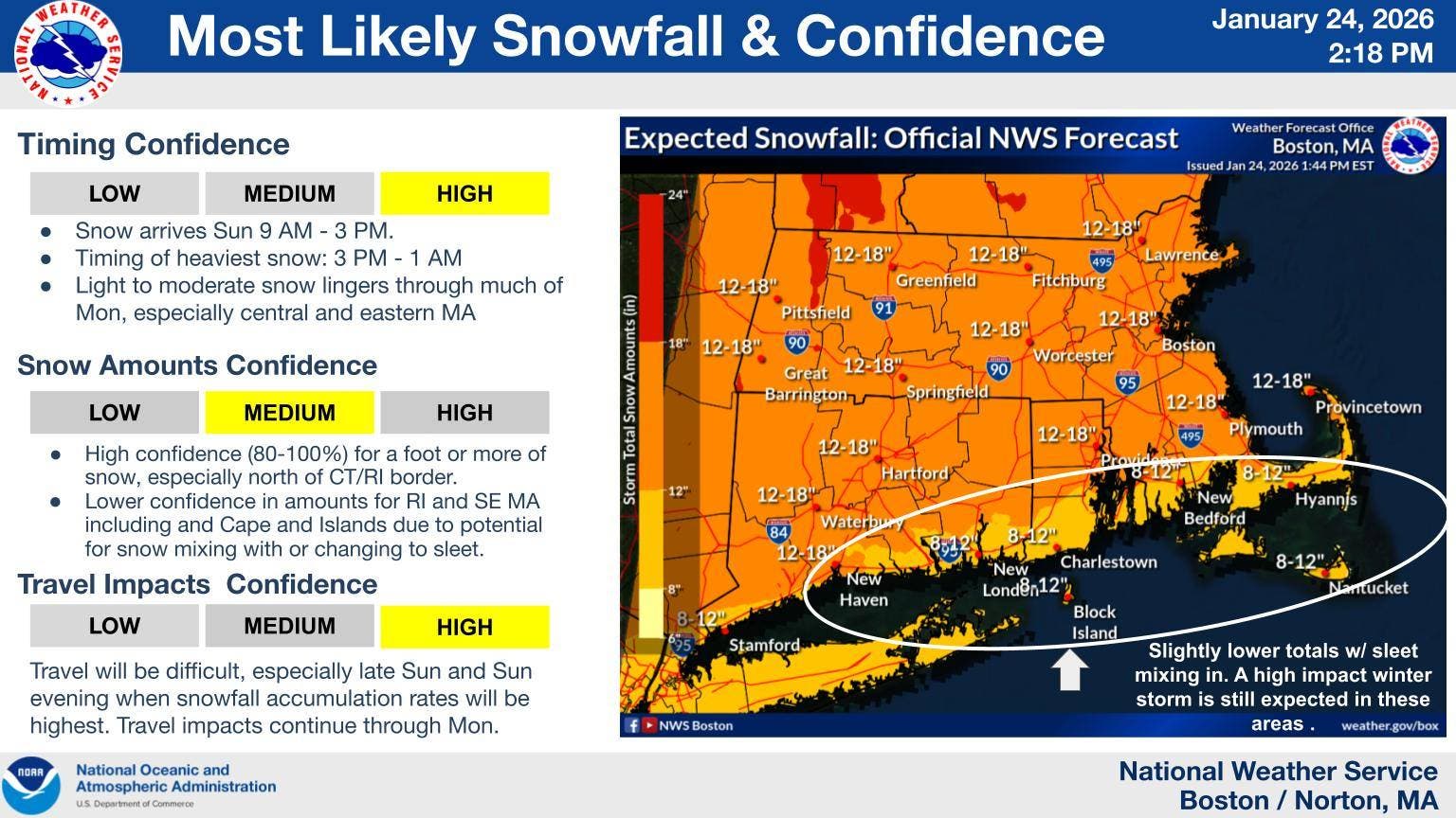
image via National Weather Service
Extended forecast details via the National Weather Service:
Tuesday: Mostly sunny, with a high near 21. West wind 6 to 9 mph.
Tuesday Night: Mostly clear, with a low around 0. West wind 3 to 6 mph.
Wednesday: Sunny, with a high near 24. West wind 3 to 8 mph.
Wednesday Night: Mostly cloudy, with a low around 4. Calm wind.
Thursday: Partly sunny, with a high near 20. Light northwest wind becoming north 5 to 9 mph in the morning.
Thursday Night: Partly cloudy, with a low around 4. Northwest wind around 8 mph.
Friday: Mostly sunny, with a high near 22. Northwest wind 9 to 11 mph, with gusts as high as 23 mph.
Friday Night: Partly cloudy, with a low around 7. Northwest wind around 8 mph.
Saturday: Mostly sunny, with a high near 27. Northwest wind 7 to 9 mph.
Get more local news delivered straight to your inbox. Sign up for free Patch newsletters and alerts.