Weather
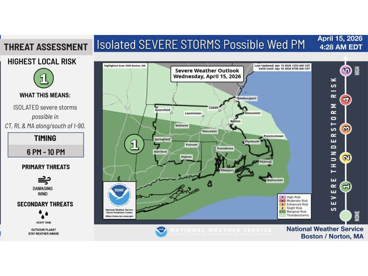
Timeline For Strong-To-Severe Thunderstorms In CT Released
The current unseasonably warm weather pattern continues, according to meteorologists.

It will be a summer-like day in Connecticut today, and then thunderstorms are possible Wednesday evening, according to meteorologists.
The National Weather Service’s Boston office reports “strong to severe” thunderstorms could impact Connecticut between 6 p.m. and 10 p.m.
“Damaging winds may down trees and powerlines,” the National Weather Service said.
Find out what's happening in Across Connecticutfor free with the latest updates from Patch.
The National Weather Service’s New York City office said it will be another “unseasonably hot day” today, with the potential for record high temperatures.
It is predicting highs Wednesday in the low to mid-80s for Connecticut.
Find out what's happening in Across Connecticutfor free with the latest updates from Patch.
“Showers and thunderstorms are possible during the late afternoon through the evening,” the New York City office reports.
WFSB is calling today a “First Alert Weather Day” due to the risk for strong storms, and it predicts the greatest chance will be in the evening through midnight.
“Heavy rainfall will be a top threat, then lightning, and possible strong or severe wind gusts. Isolated storms could pop in the afternoon too,” WFSB reports.
WFSB predicts the current unsettled pattern will continue through the workweek, with high daytime temperatures and storms also possible Thursday and Friday.
WTNH meteorologists are forecasting the possibility for “a few spotty storms” late today. For tonight, it predicts some “heavy areas of rain and thunder coming through at times.”
“Friday brings the best chance for more widespread showers and thunderstorms during the midday and afternoon as a disturbance interacts with a backdoor cold front,” WTNH reports.
Read More:
- Beloved Business Owner Dies At 27 In Crash, Mourned
- Man Accused Of Voyeurism After Spyware Tech Found In Residence: PD
- DCF: 12-Year-Old Eve Rogers Was Subject Of Prior Report
Here are the forecast details for northern Connecticut via the National Weather Service:
Today: A chance of showers and thunderstorms, mainly after 3 p.m. Partly sunny, with a high near 84. Calm wind becoming southwest 5 to 9 mph in the afternoon. Chance of precipitation is 30%. New rainfall amounts of less than a tenth of an inch, except higher amounts possible in thunderstorms.
Tonight: A chance of showers and thunderstorms. Patchy fog between 11 p.m. and 1 a.m. Otherwise, mostly cloudy, with a low around 61. South wind 3 to 7 mph. Chance of precipitation is 50%. New rainfall amounts between a tenth and quarter of an inch, except higher amounts possible in thunderstorms.
Thursday: A slight chance of showers before 7 a.m., then a chance of showers after noon. Partly sunny, with a high near 83. Southwest wind 5 to 10 mph. Chance of precipitation is 30%.
Thursday Night: A chance of showers, mainly before 2 a.m. Mostly cloudy, with a low around 60. South wind 3 to 6 mph. Chance of precipitation is 30%. New precipitation amounts of less than a tenth of an inch possible.
Friday: A chance of showers before 11 a.m., then a chance of showers and thunderstorms between 11 a.m. and 3 p.m., then showers likely and possibly a thunderstorm after 3 p.m. Mostly cloudy, with a high near 77. Light and variable wind becoming west 5 to 7 mph in the morning. Chance of precipitation is 60%.
Friday Night: Showers and thunderstorms likely before 8 p.m., then a slight chance of showers between 8 p.m. and 11 p.m. Mostly cloudy, with a low around 53. North wind around 6 mph. Chance of precipitation is 60%.
Saturday: Mostly cloudy, with a high near 69. Northeast wind 5 to 7 mph becoming southeast in the afternoon.
Here are the forecast details for southern Connecticut via the National Weather Service:
Today: A slight chance of showers between 2 p.m. and 5 p.m., then a slight chance of showers and thunderstorms after 5 p.m. Mostly sunny, with a high near 82. Calm wind becoming south 5 to 8 mph in the afternoon. Chance of precipitation is 20%.
Tonight: A chance of showers and thunderstorms. Mostly cloudy, with a low around 55. Southeast wind around 5 mph becoming calm in the evening. Chance of precipitation is 50%.
Thursday: Partly sunny, with a high near 79. Calm wind becoming south 5 to 8 mph in the morning.
Thursday Night: A 20 percent chance of showers. Mostly cloudy, with a low around 56. South wind around 5 mph becoming calm in the evening.
Friday: A chance of showers, with thunderstorms also possible after 2 p.m. Partly sunny, with a high near 73. Calm wind becoming west 5 to 7 mph in the afternoon. Chance of precipitation is 50%.
Friday Night: Mostly cloudy, with a low around 52.
Saturday: Partly sunny, with a high near 62.
Get more local news delivered straight to your inbox. Sign up for free Patch newsletters and alerts.