Weather
Winter Weather Advisory Issued As Snow, Ice Forecast For CT
Meteorologists are also tracking a potential coastal storm for Presidents' Day.

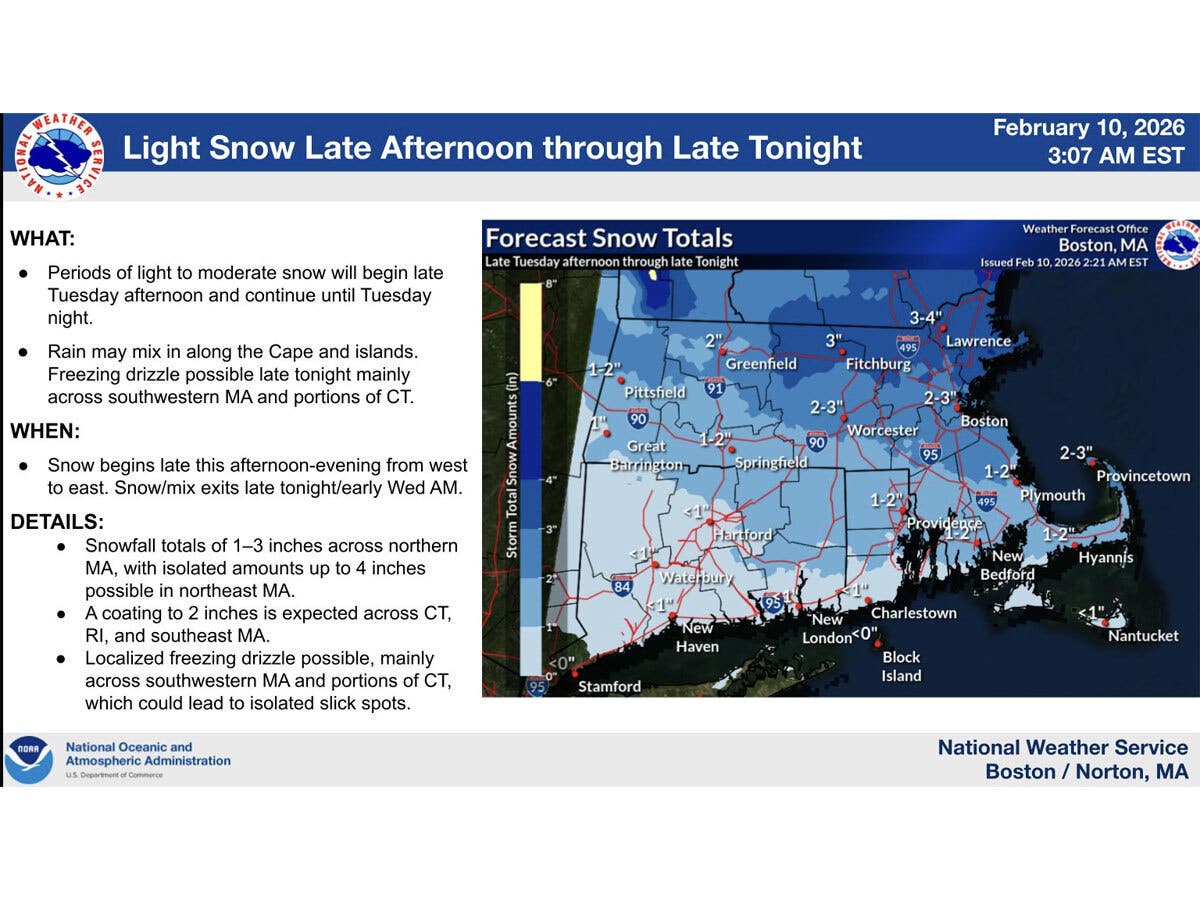
Snow is expected in Connecticut starting later today and overnight, and it will transition to freezing drizzle, according to meteorologists.
Find out what's happening in Across Connecticutfor free with the latest updates from Patch.
According to WFSB, the higher totals will be in northern and northeastern portions of the state.
The station is calling today a “First Alert Weather Day” due to the snow and potential glaze of ice, which could cause slippery conditions.
Find out what's happening in Across Connecticutfor free with the latest updates from Patch.
WTNH reports the system will bring light snow and mixed precipitation this afternoon into tonight, with “slick” road conditions, especially during the early commute on Wednesday.
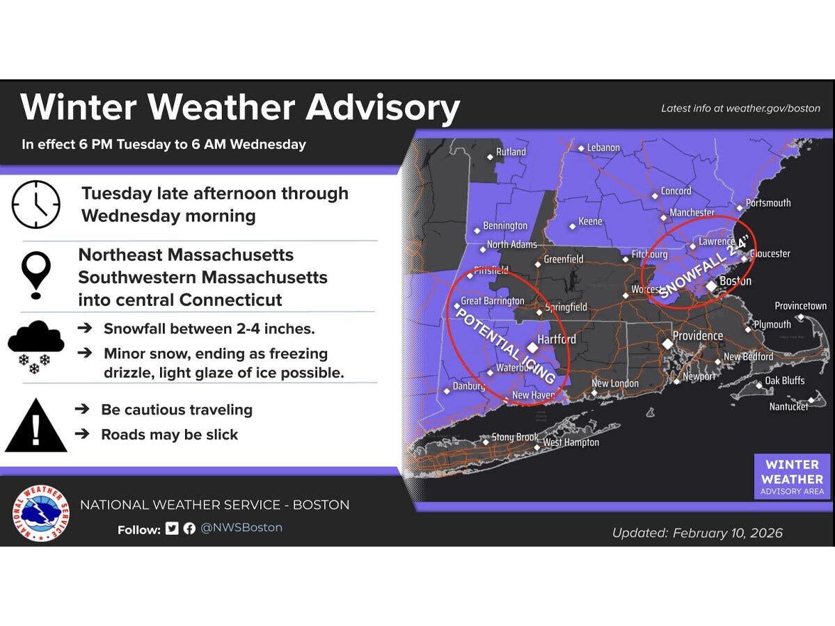
The National Weather Service has issued winter weather advisories due to mixed precipitation for most Connecticut counties starting at 6 p.m. tonight and lasting through 6 a.m. on Wednesday.
Litchfield, Hartford, Fairfield, New Haven and Middlesex counties are included in the advisories.
The National Weather Service is predicting the system arrives in southern New England late this afternoon and will last into tonight.
“Parts of southwest New England may see light icing from freezing drizzle. Roads could become slick Tuesday evening and overnight, so plan travel accordingly,” the National Weather Service advises.
Both the Tuesday evening and Wednesday morning commutes could be impacted, and motorists should be prepared for slippery roads, according to the National Weather Service. Also watch out for icy surfaces while walking, it advises.
Read More:
- Popular Restaurant Loses Liquor License For 3 Years: Report
- Teen Accused Of Firing Handgun Inside Mall Arrested: Police
- Police: Man Targeted Business In $100K+ Email Scam
A calm stretch
After this storm system passes through, the National Weather Service is predicting a stretch of dry weather from the remainder of Wednesday through the daytime on Sunday.
Daytime temperatures will reach into the mid to upper 30s during this stretch, according to the National Weather Service.
Presidents’ Day
While the bulk of Sunday is predicted to be dry, cloud cover increases later on Sunday due to an advancing coastal storm, according to WFSB.
WFSB is calling Presidents’ Day on Monday a “First Alert Weather Day” due to the potential impact from the storm.
“From snow and rain with wind to a brushing to a miss… all scenarios are on the table,” WFSB reports.
According to WTNH, a “more potent storm arrives for Sunday night through early on Presidents’ Day Monday.”
“This storm system will have lots of moisture and heavy precipitation amounts,” WTNH reports.
The National Weather Service as of Tuesday morning is reporting there is a 50 percent chance of snow Sunday night and Monday for northern Connecticut. For southern Connecticut, it is predicting a 60 percent chance of rain and snow on Sunday night, followed by a 50 percent chance of rain for Monday.
Here are the forecast details for southern Connecticut via the National Weather Service:
Today: A 20 percent chance of snow after 1 p.m. Mostly cloudy, with a high near 34. Wind chill values between 25 and 30. Calm wind becoming south around 6 mph in the afternoon.
Tonight: A chance of snow, freezing rain, and sleet before 10 p.m., then freezing rain and sleet likely between 10 p.m. and 4 a.m. Cloudy, then gradually becoming partly cloudy, with a steady temperature around 30. Light and variable wind. Chance of precipitation is 70%. Little or no ice accumulation expected. New snow and sleet accumulation of less than a half inch possible.
Wednesday: Mostly sunny, with a high near 39. Wind chill values between 25 and 30. West wind 5 to 11 mph, with gusts as high as 23 mph.
Wednesday Night: Partly cloudy, with a low around 23. Wind chill values between 15 and 20. West wind around 7 mph, with gusts as high as 20 mph.
Thursday: Sunny, with a high near 34. Northwest wind 8 to 11 mph.
Thursday Night: Mostly cloudy, with a low around 17.
Friday: Sunny, with a high near 34.
Friday Night: Mostly cloudy, with a low around 21.
Saturday: Sunny, with a high near 37.
Saturday Night: Partly cloudy, with a low around 20.
Sunday: Mostly cloudy, with a high near 37.
Sunday Night: Rain and snow likely. Cloudy, with a low around 29. Chance of precipitation is 60%.
Washington's Birthday: A 50 percent chance of rain. Cloudy, with a high near 40.
Here are the forecast details for northern Connecticut via the National Weather Service:
Today: A chance of snow, mainly after 4 p.m. Mostly cloudy, with a high near 32. Calm wind becoming south around 6 mph in the afternoon. Chance of precipitation is 30%. Total daytime snow accumulation of less than a half inch possible.
Tonight: Snow likely, mainly before 11 p.m. Cloudy, with a low around 23. South wind around 6 mph becoming calm after midnight. Chance of precipitation is 70%. New snow accumulation of 1 to 2 inches possible.
Wednesday: Partly sunny, with a high near 35. Light west wind becoming northwest 11 to 16 mph in the morning. Winds could gust as high as 28 mph.
Wednesday Night: Partly cloudy, with a low around 20. Northwest wind around 11 mph, with gusts as high as 22 mph.
Thursday: Mostly sunny, with a high near 34. Northwest wind 9 to 13 mph, with gusts as high as 23 mph.
Thursday Night: Partly cloudy, with a low around 11. Northwest wind 5 to 7 mph.
Friday: Mostly sunny, with a high near 34. West wind 5 to 8 mph.
Friday Night: Mostly cloudy, with a low around 17. Southwest wind around 6 mph.
Saturday: Sunny, with a high near 37. West wind 6 to 9 mph.
Saturday Night: Mostly clear, with a low around 9. Northwest wind around 6 mph becoming calm in the evening.
Sunday: Partly sunny, with a high near 37. Calm wind becoming south around 6 mph in the afternoon.
Sunday Night: A chance of snow. Cloudy, with a low around 25. Southeast wind around 6 mph becoming northeast after midnight. Chance of precipitation is 50%.
Washington's Birthday: A chance of rain and snow. Cloudy, with a high near 40. North wind 7 to 9 mph. Chance of precipitation is 50%.
Get more local news delivered straight to your inbox. Sign up for free Patch newsletters and alerts.