Weather
Jose Not Going Away, Could Come Close Enough To Impact Connecticut
Jose has weakened to a tropical storm, but it's expected to regain steam, and the threat of impacts to Connecticut is on the rise.



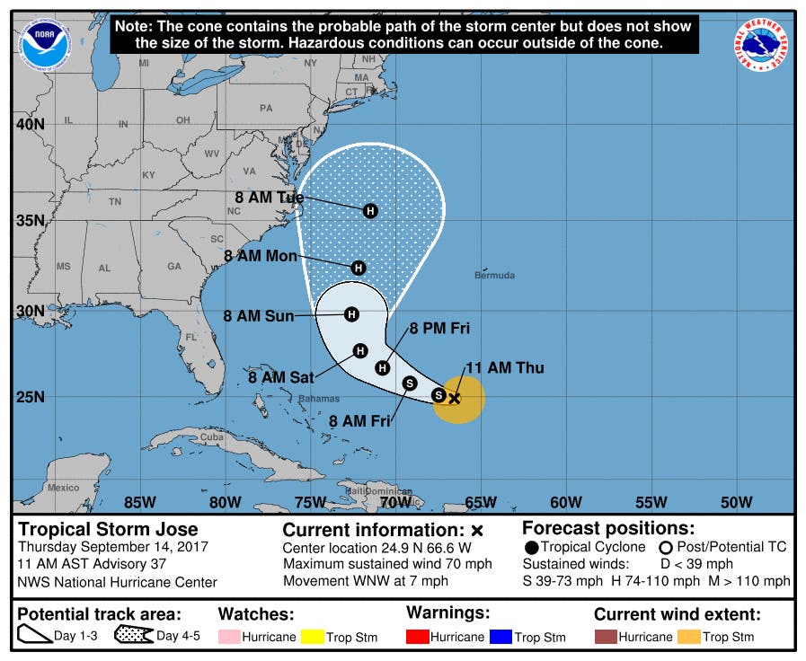
Jose remains likely to stay offshore, but its track has shifted west, and it could come close enough to impact Connecticut next week, the National Weather Service says.
The storm, currently located about 435 miles east-northeast of the Bahamas, weakened to a tropical storm Thursday morning with sustained winds of 70 mph, but it's expected to restrengthen into a hurricane by Friday night.
Wind, rain and coastal flood impacts are not out of the question for Connecticut come next Tuesday and Wednesday. WTNH News 8 Meteorologist Kevin Arnone said, “With the newest track of #Jose from the Hurricane Center there is roughly a 5%-10% chance of 'Tropical Storm Force' winds in CT next week."
Find out what's happening in Darienfor free with the latest updates from Patch.
NBC Connecticut Meteorologist Bob Maxon said on Thursday, “There is something about Jose that I don't like. It will taunt us early/middle of next week. #worthwatching #guardup #weatheraware.” (» Find Your Patch and more news of the day, including our most-read stories)
Find out what's happening in Darienfor free with the latest updates from Patch.
With the newest track of #Jose from the Hurricane Center there is roughly a 5%-10% chance of "Tropical Storm Force" winds in CT next week pic.twitter.com/FoY9HaxsZp
— Kevin Arnone (@Kevin_Arnone) September 14, 2017
Watch: Hurricanes Jose And Irma Seen From Space
NBC Connecticut Meteorologist Ryan Hanrahan in a blog post wrote, “In fact, today's European Ensemble forecast shows 20% of modeled scenarios hooking Jose back toward the (coast) with a slow stall or wobble off the Mid Atlantic. Note that this also means 80% still go out to sea.”
GFS ensembles continue the theme of a close shave with Jose next week. We're watching it. More starting at 4 p.m. @NBCConnecticut pic.twitter.com/Bbu27XF1KL
— Ryan Hanrahan (@ryanhanrahan) September 14, 2017
See also: Man Seemingly Shows Off For Popular Radio Personality, Hits 100 MPH In Lamborghini: Warrant
In a forecast discussion released at 11 a.m Thursday, the National Hurricane Center says: "A trough currently over the Lower Mississippi Valley into the northwestern Gulf of Mexico is expected to play a key role in how close Jose comes to the eastern United States. Some of the model solutions show the trough tugging on the tropical cyclone, causing a more north-northwestward motion at the end of the period, while others have the trough deflecting the cyclone more out to sea."
There's a chance the storm could stall off the Northeast coast for a time next week, according to AccuWeather.
“A persistent onshore flow in some locations may lead to coastal flooding at times of high tide for many days even if Jose remains a few hundred miles offshore,” AccuWeather Senior Meteorologist Alex Sosnowski said.
Written by Ryan Bonner. Patch Editor Brian McCready contributed to this story.
Get more local news delivered straight to your inbox. Sign up for free Patch newsletters and alerts.