Weather
Tropical Storm Watch Cancelled For Connecticut: BREAKING
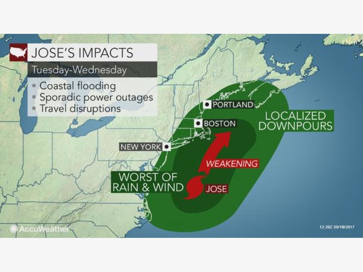
Jose's track changed once again this morning, and here are the latest details on what to expect from this storm in Connecticut.

The National Weather Service cancelled its Tropical Storm Watch that had been in effect for coastal sections of Connecticut including New Haven, Middlesex and New London counties.
NBC Connecticut Meteorologist Ryan Hanrahan said, "Good news! Tropical Storm watches have been cancelled for Connecticut this morning. Occasional squalls this afternoon and this evening with wind and rain may produce wind gusts of 30-40 mph especially on the shoreline."
There is good news this morning for Connecticut, Hurricane Jose has shifted more to the east, which means the state will just receive a glancing blow from the still category 1 hurricane. Connecticut will still see periods of rain this evening and into Wednesday, but the wind isn’t expected to be a major issue anymore. The greatest impacts will be in southeast Connecticut.
Find out what's happening in Darienfor free with the latest updates from Patch.
A Tropical Storm Watch remains for southern New Haven County, Middlesex and New London counties, while the rest of the state is under a Hazardous Weather Outlook.
WTNH News 8 Meteorologist Gil Simmons said, “...your Tuesday instacast features lots of clouds and some passing showers from time to time with highs today in the mid 70s. Some scattered rain and some wind tonight; strongest winds will be at the Shoreline followed by less wind and improving weather later tomorrow afternoon highs tomorrow also in the 70s! Nice weather if you like warmth late this week into the coming weekend with temperatures in the 80s to near 90.”
Find out what's happening in Darienfor free with the latest updates from Patch.
Few showers out there on radar! #umbrellaalert pic.twitter.com/YZetT5wsVT
— Gil Simmons (@gilsimmons) September 19, 2017
FOX 61 Weather said the “Jose effects minimal for CT - with some rain bands, some wind gusts. Worse effects for RI, Cape Cod.”
Good morning! #ICYMI #Jose has tracked a little further away from #Connecticut. Much less of an impact over the next 36 hours! pic.twitter.com/IhClWoIgXU
— Kevin Arnone (@Kevin_Arnone) September 19, 2017
WFSB Channel 3 meteorologists said Tuesday that "Jose's track shifts east: some wind, some rain for CT..."
The National Weather Service says, “Hurricane Jose will continue to track northward through the western Atlantic waters through mid week, passing to the southeast of the area late tonight into Wednesday as a tropical storm. The system looks to be close enough for potential impacts, including tropical storm force winds, coastal flooding, and locally heavy rainfall. The best chance for tropical storm force winds and heavy rain will be across eastern Long Island and southeast Connecticut. Minor to moderate coastal flooding is also likely along with dangerous surf.”
Jose forecast for southern New Haven, Middlesex, and New London counties via the National Weather Service:
Winds between 20-30 mph with occasional gusts up to 40 mph. One inch of rain is expected. The National Weather Service says showers are possible after 9 a.m. today and the best chance for rain is this evening and overnight. Showers are expected to end by 3 p.m. Wednesday.
Fairfield County:
Today: Showers likely, mainly after 9am. Cloudy, with a high near 72. Breezy, with a northeast wind 16 to 22 mph. Chance of precipitation is 60%. New precipitation amounts between a tenth and quarter of an inch possible.
Tonight: A 50 percent chance of showers. Cloudy, with a low around 65. Breezy, with a north wind 21 to 24 mph.
Wednesday: A 40 percent chance of showers before 3pm. Mostly cloudy, with a high near 76. Breezy, with a north wind 20 to 25 mph, with gusts as high as 36 mph.
Wednesday Night: Mostly cloudy, then gradually becoming mostly clear, with a low around 66. Northwest wind 9 to 14 mph.
Interior sections of New Haven County:
Today: Showers likely, mainly after 9am. Cloudy, with a high near 72. Northeast wind 14 to 18 mph. Chance of precipitation is 70%. New precipitation amounts between a tenth and quarter of an inch possible.
Tonight: Showers likely, mainly before 9pm. Cloudy, with a low around 66. Breezy, with a north wind 20 to 24 mph. Chance of precipitation is 60%. New precipitation amounts between a tenth and quarter of an inch possible.
Wednesday: A 50 percent chance of showers, mainly before 3pm. Mostly cloudy, with a high near 75. Breezy, with a north wind 20 to 25 mph, with gusts as high as 36 mph.
Wednesday Night: Partly cloudy, with a low around 64. North wind 8 to 14 mph.
Hartford County:
Today: Showers likely, mainly after 5pm. Cloudy, with a high near 72. Northeast wind 8 to 11 mph, with gusts as high as 25 mph. Chance of precipitation is 60%. New precipitation amounts between a tenth and quarter of an inch possible.
Tonight: A chance of showers. Cloudy, with a low around 66. North wind around 14 mph, with gusts as high as 29 mph. Chance of precipitation is 50%. New precipitation amounts between a tenth and quarter of an inch possible.
Wednesday: A chance of showers before 2pm, then a slight chance of showers after 4pm. Cloudy, with a high near 76. North wind 14 to 16 mph, with gusts as high as 30 mph. Chance of precipitation is 30%. New precipitation amounts of less than a tenth of an inch possible.
Wednesday Night: A slight chance of showers between 11pm and 2am. Mostly cloudy, with a low around 66. North wind 7 to 9 mph. Chance of precipitation is 20%.
Tolland County:
Today: Showers likely, mainly after 2pm. Patchy fog after 5pm. Otherwise, cloudy, with a high near 67. Northeast wind 8 to 11 mph, with gusts as high as 22 mph. Chance of precipitation is 60%. New precipitation amounts between a tenth and quarter of an inch possible.
Tonight: Showers likely, mainly between 8pm and 10pm. Cloudy, with a low around 61. North wind around 14 mph, with gusts as high as 25 mph. Chance of precipitation is 60%. New precipitation amounts between a tenth and quarter of an inch possible.
Wednesday: A chance of showers before 2pm, then a chance of showers after 3pm. Cloudy, with a high near 71. North wind 14 to 16 mph, with gusts as high as 30 mph. Chance of precipitation is 40%. New precipitation amounts of less than a tenth of an inch possible.
Wednesday Night: A slight chance of showers between 11pm and 3am. Mostly cloudy, with a low around 62. North wind 8 to 11 mph. Chance of precipitation is 20%.
Image via Accuweather.com
Get more local news delivered straight to your inbox. Sign up for free Patch newsletters and alerts.


