Weather
Jose’s Forecast Track Shifts: Here’s What It Means For Connecticut
The National Weather Service has issued a Hazardous Weather Outlook for parts of Connecticut in advance of Jose moving closer to the area.

Hurricane Jose has been a tough storm to forecast. More than a week ago, the storm was expected to head out to sea and have almost no impact on Connecticut. But the past couple of days, new data implied Jose could potentially have significant impacts on the state and some models even showed the hurricane could come very close to the state.
And now on Saturday morning, there is some good news as new models show Jose remaining more offshore than the models depicted on Friday, according to NBC Connecticut Meteorologist Ryan Hanrahan.
“Here are our overnight computer models runs with Jose. The GFS has shifted farther offshore closer to where the Euro was and is now. This means a minor Connecticut impact is becoming more and more likely. While it's too soon to rule out something more substantial the overnight trends have been encouraging,” Hanrahan wrote on social media.
Find out what's happening in Greenwichfor free with the latest updates from Patch.
The National Weather Service has issued a Hazardous Weather Outlook for southern Connecticut in advance of Jose stating, ”Tropical Cyclone Jose is forecast to lift north towards Long Island through early next week. While the exact strength and track of the storm remain uncertain, there is a low chance for strong gusty winds and heavy rain Tuesday into Wednesday.”
For Middlesex and New London counties, which would be closest to Jose’s current track, the weather service states, “A period of heavy rain and strong gusty winds are possible Tuesday into Wednesday, however the intensity will be dependent on the exact track and strength of the storm.”
Find out what's happening in Greenwichfor free with the latest updates from Patch.
No advisories have been posted for Hartford and Tolland counties but the weather service is predicting showers on Tuesday and possible tropical storm conditions Tuesday night.
WTNH News 8 Meteorologist Gil Simmons said, “Hello everyone and happy Saturday! The sun will fight through clouds today and there is a very slight threat of a shower late in the day. The humidity stays high today & tomorrow. I'm also very busy watching Hurricane Jose that will come close to Connecticut early to mid week next week! You should be watching this closely as well! There could be significant coastal flooding some wind and some rain.”
See also: Shock At The Capitol: Republican Budget Passes House and Senate
- Meteorologist Geoff Fox Makes A Decision On His Future
- Man Seemingly Shows Off For Popular Radio Personality, Hits 100 MPH In Lamborghini: Warrant
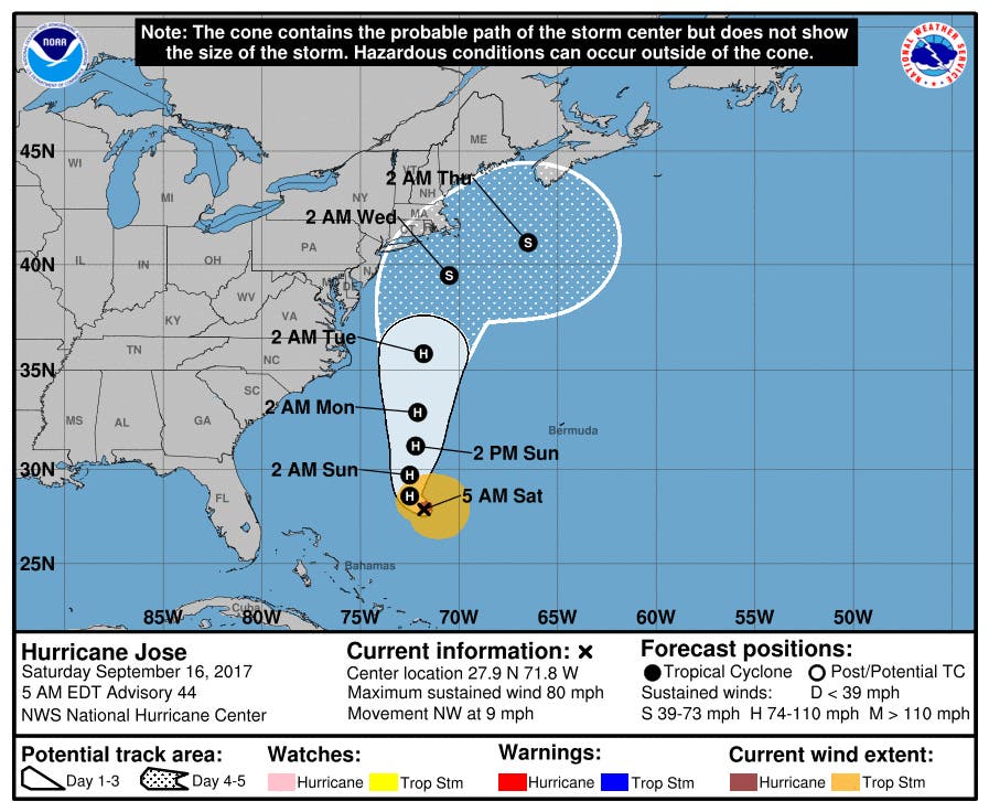
Jose, currently Category 1 storm with winds of 80 mph, was located about 550 miles south-southeast of Cape Hatteras, N.C. as of 5 a.m. Saturday. It's now expected to begin turning toward the north. A tropical storm watch may be needed for a portion of the North Carolina coast later Saturday, the National Hurricane Center says.
The NHC says there's now a 20-30 percent chance of tropical storm-force winds, meaning 39 mph or more, in Connecticut.
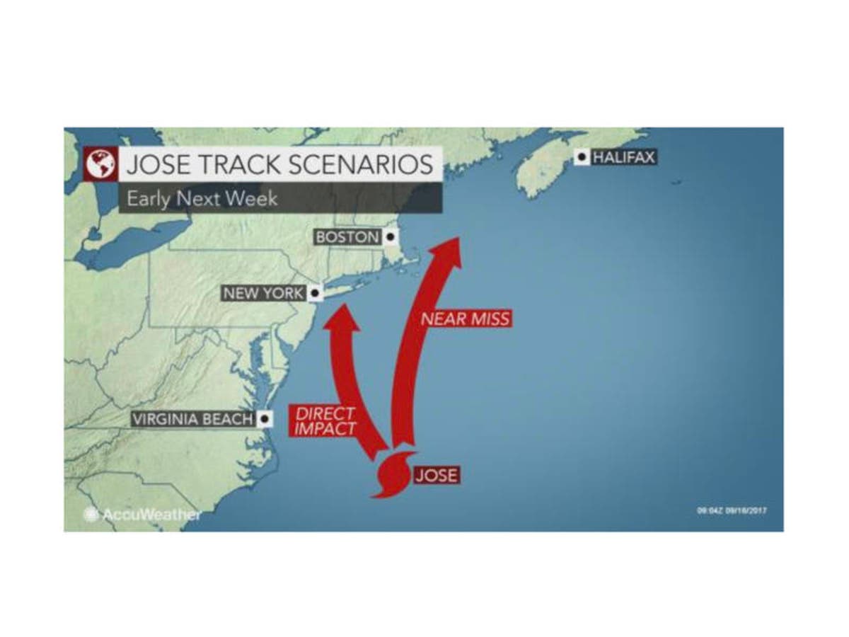
Jose is expected to remain a couple hundred miles offshore, but a hurricane does not need to make landfall to cause significant adverse effects in the Northeast since the shape of the coast tends to enhance storm effects and trap ocean water, according to AccuWeather.
And the NWS says it's important to note that typical forecast track errors 4-5 days out generally range from around 175 to 225 miles, respectively.
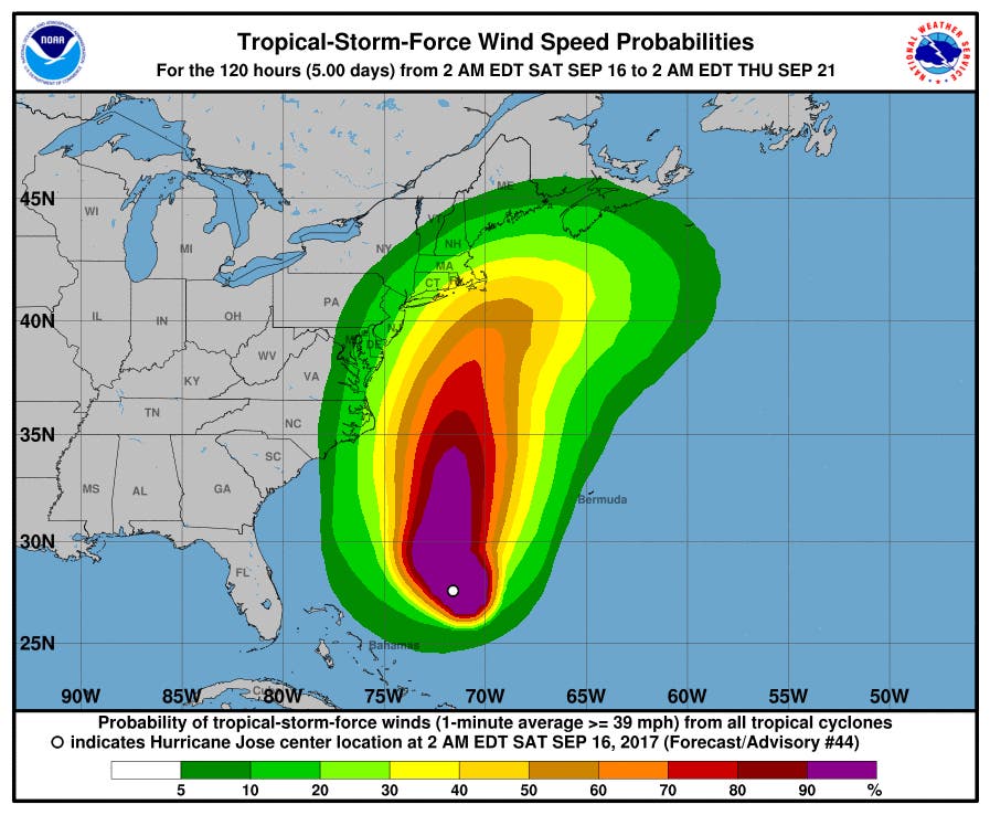
Image via Accuweather.com
Patch Editor Ryan Bonner contributed to this story.
Get more local news delivered straight to your inbox. Sign up for free Patch newsletters and alerts.


