Weather
Tropical Storm Hermine’s Possible Impact on Connecticut: Saturday Update
The National Weather Service continued a Tropical Storm Watch for parts of Connecticut. A Hazardous Weather Outlook is issued for parts too.

The National Weather Service has issued a “Tropical Storm Warning” for areas along the immediate Connecticut coastline from Greenwich to New London. (For continued updates on the storm, including news on power outages and road closures, sign up for Patch news alerts here.)
Interior areas may also experience “possible tropical storm conditions” over the Labor Day weekend too, the National Weather Service states.
A “Hazardous Weather Outlook” has been issued for Hartford and Tolland counties. Clearly, areas closest to the immediate coast are expected to receive the greatest impacts from Hermine.
Find out what's happening in Greenwichfor free with the latest updates from Patch.
And in looking at the latest update from the National Weather Service Saturday, the biggest story involving Hermine and Connecticut is the gusty wind and potential flooding at the immediate coast during times of high tide.
*Tropical Storm Warning has now been issued for coastal Connecticut. See updated story:
Find out what's happening in Greenwichfor free with the latest updates from Patch.
While Connecticut won’t experience a direct hit, the entire state could be dealing with impacts now lasting into Wednesday, the weather service states.
WTNH News 8 Meteorologist Gil Simmons said “8AM updated Hermine forecast track. Just beginning to come out over the Atlantic. Slowing & strengthening likely through tomorrow! Roughest weather for us-tomorrow afternoon through early Monday & another round possible Tuesday.”
NBC Connecticut Meteorologist Ryan Hanrahan said, “The track of Hermine is becoming more clear. We get a glancing blow with some wind, a bit of rain, and minor coastal flooding. Overall not a huge deal. Farther south, the storm could be much more significant in New Jersey and Delaware if some of the closer to the coast scenarios shown below verify. Still some details to work out. Expect a mainly dry day Sunday with some showers Sunday night and Monday.”
See also: 3 Dead in Accident in CT After Pursuit Early Saturday
- Meteorologist Geoff Fox Diagnosed with Cancer
- CT Man Arrested for Threatening Sandy Hook School on First Day: PD
Here’s the latest look at what you can expect this Labor Day weekend involving the forecasted impact from Hermine via the National Weather Service:
Connecticut immediate coastline, from Fairfield, New Haven, Middlesex, and New London counties:
On Sunday and Monday, winds will be between 25-35 mph with gusts to 55 mph. There is also a “reasonable threat for strong tropical storm force winds of 58 to 73 mph,” the weather service states.
Along the immediate coast, winds could cause some property damage and power outages.
The storm surge is the greatest concern as there is the potential for the surge to be 2-4 feet above ground beginning Sunday morning, the weather service states.
Rain is expected between 1 and 1.5 inches total. Flooding is not considered a great concern with this storm.
Saturday will be partly sunny with temps in the upper 70s. It looks like rain won’t really start to fall until later on Sunday evening and the heaviest rain may fall on Labor Day between 9 a.m. and 1 p.m.
The chance for rain falls below 50 percent on Monday afternoon and evening and drops to just 30 percent on Tuesday. Again the biggest issue with this storm is wind and storm surge on the immediate coast.
Interior areas of Fairfield, New Haven, Middlesex, and New London counties:
The weather service says tropical storm conditions are possible beginning Sunday and continuing into Wednesday. Gusty winds will be the real issue during this period of time. This is not expected to be a huge rainmaker.
It will be partly sunny Saturday with temps in the mid 70s.
Sunday will be partly sunny now, as rain isn’t expected until Sunday night now. More showers possible on Monday and the rain chances continue Monday night into Tuesday. However, chances for rain are less than 50 percent Monday night and Tuesday.
Hartford and Tolland counties:
No Tropical Storm Watch here, but a Hazardous Weather Outlook has been issued.
“Tropical Storm Hermine may impact southern New England Sunday into Tuesday with rain and wind threat. However, there is still uncertainty with the track and intensity of Hermine which will determine the magnitude and extent of impact,” the weather service states. On Saturday, expect mostly sunny skies here with temps in the mid 70s, partly sunny skies on Sunday too.
The chance for rain here begins Sunday night, likely after midnight and showers are possible on Labor Day and should end Monday night. Labor Day will be cloudy with temps only in the low 70s with the chance of showers.
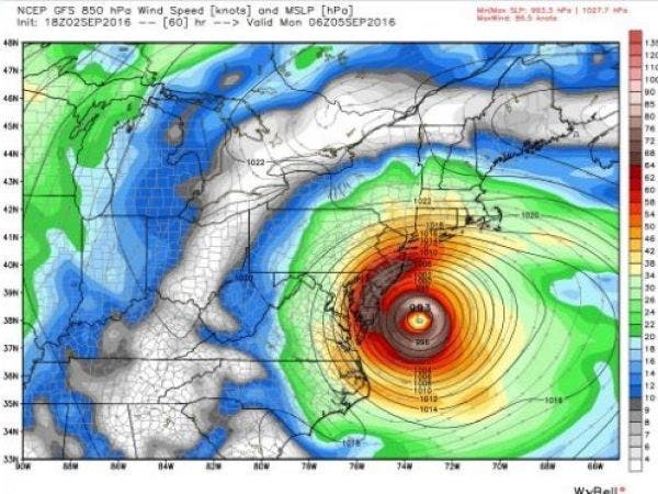
Hermine’s Latest Path
Hermine is forecast to move slowly northeast away from the Mid Atlantic Coast today. The storm is expected to drift north northeast while slowly intensifying tonight through early next week.
It will then gradually pick up pace and slowly weaken and track southeast of Long Island and Cape Cod during the middle of next week, the National Weather Service states.
Photo: NWS
Get more local news delivered straight to your inbox. Sign up for free Patch newsletters and alerts.