Community Corner
WEATHER ALERT: Significant Snowstorm to Hit Connecticut Late Sunday Into Monday
The National Weather Service has issued a Winter Storm Watch for the entire state beginning Super Bowl Sunday evening.


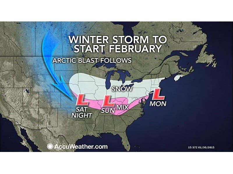
The National Weather Service, after a few days of going back-and-forth on whether a winter storm on late Super Bowl Sunday and into Monday would ever materialize, has finally made its decision, and it likely means a lot of snow for Connecticut.
The entire state of Connecticut is under a Winter Storm Watch which means there is a potential for a minimum of six inches of snow.
The National Weather Service is actually predicting 8-12 inches of snow before the storm ends Monday evening with some ice possible as well. Winds will also be gusting to about 20 miles per hour on Monday as well.
Find out what's happening in Manchesterfor free with the latest updates from Patch.
It certainly won’t be a blizzard but after a foot to two feet of snow fell on most of the state earlier this week it’s going to get interesting as to where to put all of the newly fallen snow.
The Winter Storm Watch is in effect from 7 p.m. Sunday until 6 p.m. Monday.
Find out what's happening in Manchesterfor free with the latest updates from Patch.
Here is what you need to know.
Super Bowl Sunday plans
Right now, and of course we’re getting our information from the National Weather Service, your Super Bowl Sunday plans seem ok.
Yes, the Winter Storm Watch is in effect beginning at 7 p.m. and the Super Bowl doesn’t kick off until 6:25 p.m., but the actual snowflakes aren’t supposed to begin until 10 p.m. Sunday.
The game should end right around there. We will continue to update the timeline.
Sunday into Monday forecast
Fairfield, New Haven and New London counties are all expected to receive 3-5 inches by Monday morning.
Middlesex, Hartford and Tolland counties are expected to receive 2-4 inches of snow by Monday morning.
Monday’s forecast by county
For New Haven County an additional 4-9 inches of additional snow is possible on Monday.
More interior locations such as Naugatuck, Southbury and Oxford are expected to receive an additional 5-9 inches, while Milford, which is on the coastline, is expected to receive 4-8 additional inches of snow.
But the further west you go on the Shoreline such as Branford, Guilford and Madison, you could receive 5-9 additional inches of snow as well.
For Fairfield County if you’re on the coastline such as Greenwich, New Canaan, Darien, Fairfield and Stratford you’re forecast to receive 3-5 inches of additional snow accumulation Monday because it will mix with sleet and freezing rain.
But interior locations such as Brookfield and Newtown can receive an additional 5-9 inches of snow on Monday.
For Hartford and Tolland counties expect heavy snow on Monday at times with an additional 3-5 more inches of snow before it ends Monday evening.
New London County could see an additional 5-9 inches of new snow accumulation on Monday as well.
And yes, there is a chance for more snow on Wednesday. Winter is definitely back.
More stories on Patch include:
Get more local news delivered straight to your inbox. Sign up for free Patch newsletters and alerts.