Community Corner
WEATHER UPDATE: Snow to Have 'Big Impact' on Tuesday's Evening Commute
Snow and ice could make Wednesday morning's commute 'treacherous' and significant snow accumulation is possible for Thursday.

You might want to sneak out of work a little early today, probably by 4 p.m., just to be on the safe side.
And you might want to consider options for Thursday because more than 6 inches of snow could fall late Wednesday into Thursday afternoon.
Yes, more snow is forecast for tonight’s commute home from work, expected to begin falling around 4 p.m., and it could be relatively heavy in intensity before it changes to ice late Tuesday, and then some light rain showers on Wednesday.
Find out what's happening in South Windsorfor free with the latest updates from Patch.
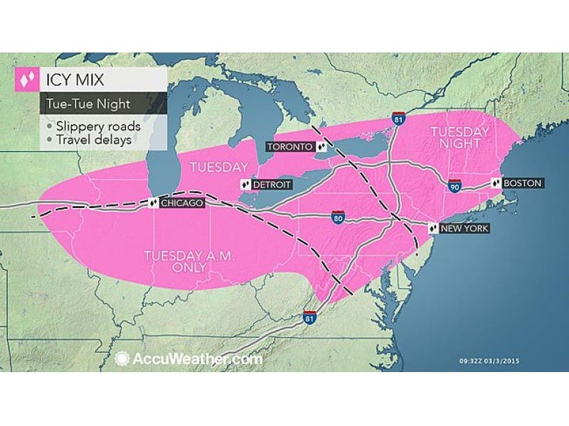
The National Weather Service has issued a Winter Weather Advisory for the entire state of Connecticut from 3 p.m. today until 10 a.m. Wednesday.
A total of 2 to 4 inches is expected, but what has prominent Connecticut meteorologists concerned is the icing that is going to occur and that could make Wednesday morning’s commute “treacherous,” writes WFSB 3 TV Meteorologist Scott Haney.
Find out what's happening in South Windsorfor free with the latest updates from Patch.
And the ride home from work tonight won’t be a walk in the park either.
NBC Connecticut Meteorologist Bob Maxon predicts snow will begin tonight after 4 p.m. and it will have a “big impact on the evening commute.”
WTNH News 8 Meteorologist Gil Simmons writes that it will be a “very rough commute” home tonight, and “snow and dangerous freezing rain and sleet” will impact Wednesday morning’s commute.
Simmons predicts snow could begin falling by 4 p.m. in Western Connecticut and by 6 p.m. in Eastern Connecticut.
As for Thursday’s potential snowstorm?
“I may have to go into hiding if current guidance verifies Thursday. Models aggressive with moisture plume & cold air Thursday morning,” Simmons wrote on Facebook.
NBC Connecticut Meteorologist Brad Field wrote on Facebook “thinking late Wednesday night/Thursday snow could be substantial...still a bit too early to be more certain…”
Here is South Windsor’s latest hyper local forecast from the National Weather Service:
- This Afternoon: Snow likely, mainly after 5pm. Mostly cloudy, with a high near 30. South wind 3 to 8 mph. Chance of precipitation is 60%. Total daytime snow accumulation of less than one inch possible.
- Tonight: Snow, freezing rain, and sleet, becoming all freezing rain after 1am. Patchy fog between 10pm and midnight, then Patchy fog between 1am and 4am. Low around 26. South wind 7 to 9 mph. Chance of precipitation is 100%. New snow and sleet accumulation of 2 to 4 inches possible.
- Wednesday: A chance of rain, mainly after 5pm. Cloudy, with a high near 42. Southwest wind 6 to 8 mph. Chance of precipitation is 30%. New precipitation amounts of less than a tenth of an inch possible.
- Wednesday Night: A chance of rain and snow before 9pm, then a chance of snow and sleet between 9pm and 11pm, then snow likely after 11pm. Patchy fog between midnight and 5am. Patchy freezing fog after 5am. Otherwise, cloudy, with a low around 23. Northwest wind 6 to 8 mph. Chance of precipitation is 70%. New snow and sleet accumulation of 1 to 3 inches possible.
- Thursday: Snow likely, mainly before 10am. Patchy fog before 1pm. Otherwise, cloudy, with a high near 25. Northwest wind around 9 mph. Chance of precipitation is 70%.
- Thursday Night: Partly cloudy, with a low around 4.
Photo courtesy of Accuweather.com
Other stories on Patch:
Get more local news delivered straight to your inbox. Sign up for free Patch newsletters and alerts.