Politics & Government
Update: Hurricane Earl Looms
Region braces for the possibility of a hurricane making landfall on Labor Day weekend.


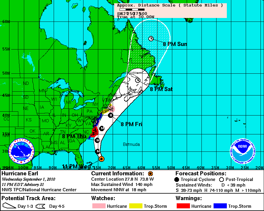


Update, 1:28 p.m.: The latest National Weather Service bulletin says there's a 48% chance of tropical storm conditions in lower Fairfield County, up from 40% in the last update.
"There is an increasing chance for combined storm surge and astronomical tide waters up to 2 to 3 feet above mean sea level within areas closer to the coast, resulting in worst case flood inundation up to 1 to 2 feet above ground level somewhere within the surge zone," the NWS reports.
"Large waves Friday into the weekend will cause substantial beach erosion," the service adds.
Find out what's happening in Wiltonfor free with the latest updates from Patch.
Earl is projected to pass some 150 miles east of Montauk Friday night. As of 12 p.m., the storm center was about 680 miles south of New York City.
Update, 9:00 a.m.: The projected path of Hurricane Earl as it glances our region pushed a bit further to the east overnight, but lower Fairfield County remained under a tropical storm watch as of 8 a.m.
Find out what's happening in Wiltonfor free with the latest updates from Patch.
The National Weather Service said there's now a 40-50 percent chance of tropical storm force winds affecting Wilton and a 10-20 percent chance of winds topping 58 mph.
Earl strengthened further overnight with maximum sustained winds reaching 145 mph, but the NWS said it expects the storm to begin weakening later today. It is currently 700 miles south of Long Island and expected to ultimately pass around 150 miles sotheast of the same area on Friday night.
Update - Tuesday, Sept. 2, 1:25 a.m.
A tropical storm watch continues for Southern Fairfield County as Hurricane Earl sits spinning just under 1,000 miles south of New York City.
The storm was heading NNW at 18 mph with winds around 140 mph as of 11 p.m. Wednesday. The NWS expected to release their newest forecast update at 7 a.m. on Thursday.
At present, the local forecast is calling for heavy rain to roll into Wilton Friday evening as part of Earl's outskirts, with wind gusts topping out around 30 mph.
Showers and thunderstorms are expected to continue into Saturday.
Update - 8:05 p.m.The National Weather Service said this evening that the probability of Lower Fairfield County experiencing tropical storm conditions from Hurricane Earl had climbed slightly to 40 percent, though the NWS's models still projected winds to stay "just below tropical storm force."
The odds of hurricane conditions are "very low," the service said, but coastal areas of the county could still experience a four to six-foot storm surge in a worst case scenario.
"There is a general concern for the chance of areas of minor to moderate coastal flooding," the NWS said. "The best chance of moderate flooding will be across western Long Island Sound."
The NWS also warned of "life threatening" rip currents along Atlantic-facing shores.
Earlier in the day, NWS issued a tropical storm watch for the Connecticut shoreline and much of the New England coast. The National Hurricane Center reported that Earl had picked up some strength lost earlier in the day to regain its category 4 designation, with a maximum sustained wind speed of 135 mph.
The NHC predicted that the center of the storm will pass to the east of Long Island some time Friday night, avoiding a direct hit to the Tri-State Region but still promising wind, heavy rain, large waves, and storm surges.
The alert means that tropical storm conditions are possible in the area, generally within 48 hours.
As of 5 p.m., the storm was several hundred miles east of the Bahamas moving northwest at 17 mph. Hurricane force winds extended up to 90 miles from the center, while tropical storm winds reached up to 200 miles away.
The latest projections give lower Fairfield Country a 30-40% chance of experiencing tropical storm force winds—defined by a sustained speed of over 39 mph—and a 5-10% chance of experiencing winds in excess of 58 mph.
By late Thursday, the center of Earl is expected to approach the North Carolina shore, which is now under a hurricane warning.
Original Article: Many are keeping a watchful eye on Earl, the hurricane currently off the southern U.S. coast.
For now, the weekend forecast only includes rain on Friday and windy conditions on Saturday. But the Connecticut Department of Emergency Management and Homeland Security has released the following tracking update:
After moving just east of the outer banks, Earl is forecast to accelerate to the North Northeast on Friday and brush Southeastern New England Friday evening as a Category II hurricane. However, eastern Connecticut is within the 3-day margin for error for Earl's track and all interests should continue to monitor Earl closely. If Earl stays on this new forecast track parts of Southeastern New England can expect Tropical Storm force winds, heavy rain and high waves Friday night. Heavy rainfall may cause urban and small stream flooding in Southeastern CT Friday evening.
That latter scenario doesn't sound too promising.
Connecticut Light and Power has already sent out releases ahead of time to prepare its customers and assure them that the company will be doing its best to maintain power and respond if it should fail.
"We're...in very close contact with state and emergency management officials to make sure all of our efforts are coordinated, so we can respond as quickly and safely as possible," said Mike Zappone, manager of System Restoration and Emerency Preparedness at CL&P in a release.
CL&P is encouraging customers to prepare a "storm kit" that includes:
- Flashlights with spare batteries
- A battery-operated radio or TV
- First-aid kit
- Canned, freeze-dried or dehydrated foods
- A manual can opener
- Bottled water
- Baby or pet supplies (if needed)
- Important phone numbers
The company is also advising residents that need power for life support equipment (respirators, etc.) to have backup plans "to cope with storm-related outages."
Residents can follow CL&P for breaking updates at http://twitter.com/CTlightandpower. And, of course, stay tuned to Patch for the latest.
Get more local news delivered straight to your inbox. Sign up for free Patch newsletters and alerts.