Weather
Virginia, DC Forecast: Snow In Hazardous Outlook
BREAKING: More snow is in the forecast for Monday. DC and northern Virginia are now under a hazardous weather outlook.


WASHINGTON, DC — More snow is on the way early this week for the Washington, D.C., region. The snow is expected Monday, and winter weather advisories may be required for northern Virginia, according to the National Weather Service. The forecast from the weather service shows potential snow and rain showers on Monday, transitioning to snow by Monday night.
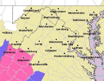
So far, the weather service has issued a hazardous weather outlook for possible snow for the District of Columbia, Prince William, Manassas, Manassas Park, Fairfax, Arlington, Falls Church, Alexandria, Stafford, Spotsylvania, and King George areas.
When and how much snow falls remain uncertain. A winter storm warning is in effect for portions of west-central Virginia, and winter weather advisories may be required further north and east, the weather service said early Sunday. That said, the storm remains difficult to predict, and a significant range of possibilities still exists.
Find out what's happening in Washington DCfor free with the latest updates from Patch.
So far, The Washington Post's Capital Weather Gang says the snow won't amount to much in the Washington area, but that could change if it turns colder. "This has been a difficult forecast and could still change a bit. For now, we’re favoring a low-impact scenario, with areas of light snow possible but having a tough time sticking to roads and sidewalks, given temperatures rising through the 30s to near 40 and the strengthening March sun. That said, can’t rule out a bit of road slush if we get an early-morning burst of snow," the Weather Gang predicts.
The snow is part of a weather system coming in from central Virginia. That area is under a winter storm warning from 8 p.m. Sunday to 2 p.m. Monday, issued by the National Weather Service, calling for 3 to 6 inches of heavy snow.
Find out what's happening in Washington DCfor free with the latest updates from Patch.
The forecast for northern Virginia and the District calls for up to an inch of snow between Monday and Tuesday. There is a 30 percent chance of snow after 2 a.m. tonight, with a low around 33. On Monday snow is likely before 2 p.m., then look for a rain and snow mix, according to the National Weather Service. Chance of precipitation is 70 percent with less than one inch of new snow accumulation expected.
"The March sun angle will play a role in how much snow can accumulate, and whether or not we see a rain/snow mix..." according to the National Weather Service forecasters. "At this point, forecast confidence regarding extent of accumulative snow coverage remains below average," the weather service says. "Snow amounts will depend on the storms track as well as surface temperatures."
Accuweather Forecast: Flurries Sunday, Rain-Snow Monday
The experts at Accuweather predict anywhere from 0.2 to to 1 inch of snow between Monday and Tuesday in the Baltimore-Washington area. There may be a flurry overnight Sunday into Monday, according to that agency's forecast.
Accuweather says that precipitation on Monday will likely start with rain in the afternoon, transitioning to "a bit of of snow in the evening," with approximately a coating to an inch of snow by Tuesday morning.
Weather Channel: "Light Snow And Gusty Winds" May "Brush" Mid-Atlantic
The Weather Channel forecasters say that northern Virginia may see a wintry mix that will be relatively light, before it dumps more than 6 inches of snow on eastern New England.
"At least light snow and gusty winds may brush the coast from the mid-Atlantic northward to the New York City metro," The Weather Channel says. "Parts of the immediate coast may see a rain/snow mixture."
The news of this possible snow comes after back-to-back winter weather events blew through Virginia last week, leading to road closures, school closings and power outages.
The first storm descended upon the region on March 2. Widespread power outages resulted from the Friday storm — nearly 600,000 customers in the Washington, D.C., metro were without electricity at one point.
Viringia dodged a bullet with Wednesday's storm, which for neighboring areas was a monster, dumping as much as 16 inches of snow in the suburbs of Philadelphia. Roads were not passable, schools were closed and more mass power outages resulted there.
National Weather Service Forecast For Northern Virginia
Tonight: A chance of snow after 2am. Mostly cloudy, with a low around 33. Northeast wind 3 to 6 mph. Chance of precipitation is 30%.
Monday: Snow likely before 2pm, then rain and snow likely. Cloudy, with a high near 40. Northeast wind around 8 mph. Chance of precipitation is 70%. New snow accumulation of less than one inch possible.
Monday Night: Rain likely, possibly mixed with snow showers before 8pm, then a chance of snow showers. Cloudy, then gradually becoming partly cloudy, with a low around 30. Northwest wind 5 to 9 mph. Chance of precipitation is 60%. New snow accumulation of less than a half inch possible.
Tuesday: Mostly sunny, with a high near 46. Northwest wind 9 to 15 mph, with gusts as high as 25 mph.
Tuesday Night: Partly cloudy, with a low around 28.
Wednesday: Mostly sunny, with a high near 42.
Wednesday Night: Partly cloudy, with a low around 29.
Thursday: Mostly sunny, with a high near 49.
Thursday Night: Mostly clear, with a low around 34.
Friday: Sunny, with a high near 55.
SIGN UP: For more news like this, find your local Patch here. If you have an iPhone, click here to get the free Patch iPhone app; download the free Patch Android app here.
Photo via Shutterstock, graphic via the National Weather Service
Get more local news delivered straight to your inbox. Sign up for free Patch newsletters and alerts.