Weather
Coastal FL Storms: Strong Winds, Flooding And Heavy Downpour Forecast
Meteorologists predict the impending weather system could threaten lives and property, and make for hazardous Florida beach conditions.


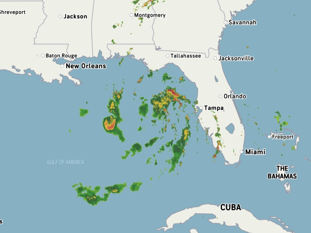
FLORIDA — Dangerous beach conditions, inches of rainfall and possible flooding are all forecast for the Sunshine State the remainder of this week and into the weekend, AccuWeather meteorologists predicted, with a potential threat to lives and property.
The cause for the major rainfall is due to an anticipated outpouring of moisture from the southwestern Atlantic and the Gulf of Mexico that is expected to be caused by a storm arriving from the southern Rockies, AccuWeather reported.
A high-pressure system traveling through the central and eastern U.S. forecast to limit its motion through the remainder of the week is also a contributing factor to the anticipated wet weather pattern, AccuWeather said.
Find out what's happening in Across Floridafor free with the latest updates from Patch.
“The persistent easterly flow from the ocean will not only cause water to pile up on southern Atlantic beaches, but also lead to water backing up on the tidal rivers, including the St. Johns in Florida, the Savannah in Georgia and the Congaree in South Carolina,” AccuWeather Senior Meteorologist Alex Sosnowski said in a news release.
Beaches are currently experiencing gusty winds ashore areas along Florida's east coast, AccuWeather said.
Find out what's happening in Across Floridafor free with the latest updates from Patch.
Wind speeds will increase throughout the day Wednesday, with gusts reaching 30 mph or higher by Thursday and remaining at that strength through Saturday day, the National Weather Service in Tampa said. (See the latest NWS forecast for Tampa Bay at the bottom of this story.)
Several portions of Florida are under a small craft advisory Wednesday due to northeast winds around 20-25 knots in the Atlantic, according to the NWS.

Seas are forecast to climb 5-7 feet near the shore and 7-10 over the Gulf and offshore Wednesday night. A gale warning will go into effect at 10 p.m. Wednesday, when the weather service said vessels should remain in port.
The weather service predicted storms to move over the Atlantic into Wednesday night.
Late morning winds with gusts near 30 mph are developing and are forecast to last through the afternoon.
"Small items can be tossed by the wind, and high profile vehicles may be challenging to fully control on bridges and causeways," the weather service reported.
Beach erosion is expected Wednesday evening and will return early Thursday during the peaks of high tide, the weather service said. High winds and the increased risk of rip currents are set to impact surf conditions.
As for the remainder of the week through Tuesday, the weather service is expected to issue a high surf advisory, triggered by strong rip currents and large breaking waves. Minor flooding along the coast and beach erosion are possible.
"The exact track of the storm system will determine if the thunderstorms become severe and could bring tornadoes and powerful wind gusts. The most likely time for severe thunderstorms in the central and southern parts of the Florida Peninsula and Keys will be from late in the day Saturday to early Sunday," AccuWeather reported.
Here's the latest forecast for the Tampa Bay area:
Wednesday: Partly sunny, with a high near 78. Breezy, with an east northeast wind around 15 mph, with gusts as high as 23 mph.
Wednesday Night: Partly cloudy, with a low around 62. Breezy, with a northeast wind 14 to 18 mph, with gusts as high as 28 mph.
Thursday: Mostly cloudy, with a high near 76. Windy, with an east northeast wind 18 to 21 mph, with gusts as high as 31 mph.
Thursday Night: Mostly cloudy, with a low around 63. Windy, with an east northeast wind 18 to 22 mph, with gusts as high as 32 mph.
Friday: Mostly cloudy, with a high near 75. Windy, with an east northeast wind 20 to 22 mph, with gusts as high as 34 mph.
Friday Night: A 20 percent chance of showers and thunderstorms after 1am. Cloudy, with a low around 64. Windy, with an east northeast wind 18 to 20 mph, with gusts as high as 30 mph.
Saturday: A chance of showers and thunderstorms, then showers likely and possibly a thunderstorm after 1pm. Mostly cloudy, with a high near 73. Windy, with an east northeast wind 18 to 22 mph, with gusts as high as 32 mph. Chance of precipitation is 70%.
Saturday Night: Showers and possibly a thunderstorm. Low around 64. Windy, with an east wind around 22 mph, with gusts as high as 33 mph. Chance of precipitation is 80%.
Sunday: Showers likely and possibly a thunderstorm before 1pm, then a chance of showers and thunderstorms after 1pm. Partly sunny, with a high near 73. Windy, with a south wind 21 to 24 mph becoming west in the afternoon. Winds could gust as high as 37 mph. Chance of precipitation is 60%.
Sunday Night: A chance of showers and thunderstorms before 1am, then a slight chance of showers. Mostly cloudy, with a low around 59. Windy. Chance of precipitation is 30%.
Monday: A 20 percent chance of showers. Mostly sunny, with a high near 67. Windy.
Get more local news delivered straight to your inbox. Sign up for free Patch newsletters and alerts.