Weather
2 Atlantic Tropical Disturbances Making Westward Progress
One of the two tropical disturbances churning in the Atlantic Ocean has been given a strong chance of developing over the next few days.


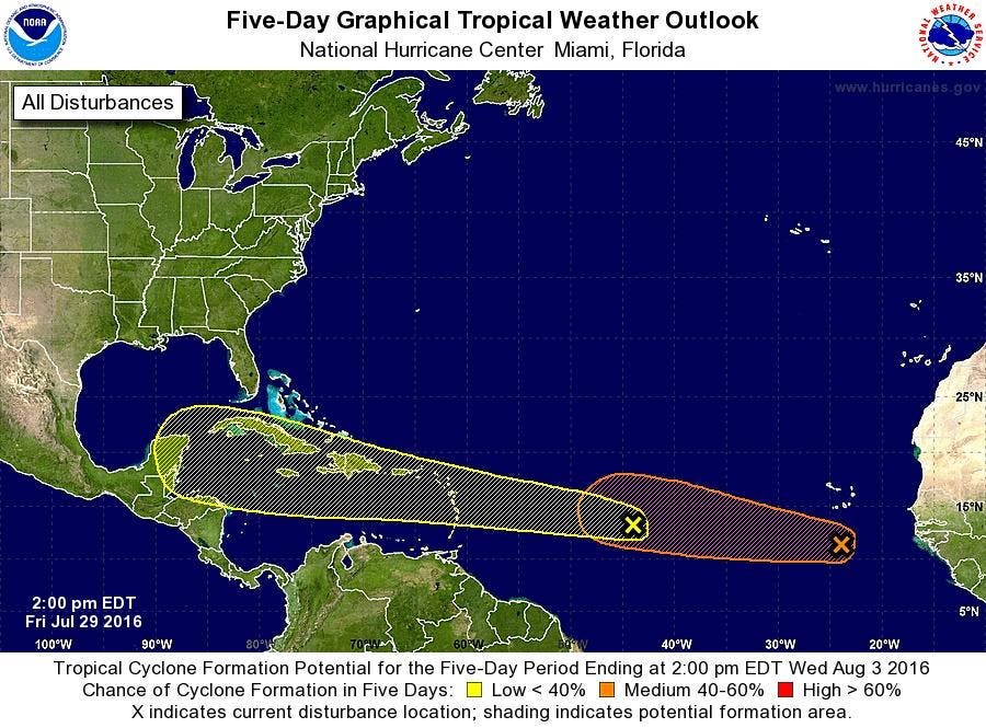
TAMPA BAY, FL — While it remains too soon to tell if the two tropical disturbances churning in the Atlantic Ocean will have any impact on Florida or the United States, both storms have remained on a steady westward track over the past day. One of the two storms, the National Hurricane Center says, has a strong chance of developing over the next five days.
The first disturbance under watch by the hurricane center is a tropical wave that is currently located about 1,100 miles east of the Lesser Antilles. That storm was moving west between 20 and 25 mph as of Friday afternoon. The storm’s chances of developing over the next five days into a more organized system were set at 30 percent Friday afternoon.
While this tropical wave poses no immediate threat to the United States, forecasters say it merits a close watch despite its current poorly organized state.
Find out what's happening in Clearwaterfor free with the latest updates from Patch.
“By the middle of next week, the wave is expected to be in the western Caribbean Sea, where conditions could be more conducive for development,” the hurricane center wrote in its 2 p.m. Friday report.
The second disturbance is a tropical wave and low pressure system. It was located a few hundred miles south of the Cabo Verde Islands Friday afternoon and “continues to show signs of organization.” Even so, forecasters say the system does not have a well-defined area of circulation.
Find out what's happening in Clearwaterfor free with the latest updates from Patch.
The storm has been given a 40 percent chance of further development over the next 48 hours and a 50 percent chance over the next five days.
“Some development is possible during the next day or two before the disturbance encounters a less favorable environment over the central tropical Atlantic early next week,” the center’s report said.
While it’s still way too early to tell what, if any, impact the storms will have on Tampa Bay, the hurricane center is keeping close tabs on their movements. Should the storms develop more, they would become the fifth and sixth named storms of the 2016 Atlantic Hurricane Season. Their names would be Earl and Fiona, respectively.
So far this year, the only named storm that created concern for Tampa Bay was Tropical Storm Colin. That storm passed by in early June, dumping lots of water and creating some flooding in the region.
The Tampa Bay area hasn’t been struck by a hurricane in more than 90 years. The last major storm to come close to the region was Hurricane Charley back in August 2004. That category 4 storm ripped through Charlotte County, leaving four people dead in its wake and an estimated 11,000 homes damaged.
While Tampa Bay has been lucky for a long time, experts say the streak isn’t likely to last. It’s not a question of if, but when, forecasters say.
To get ready, residents are urged to create their own emergency kits, including food and water for at least three days. They should also know their evacuation routes, have their renter or homeowner’s insurance documents handy and should have a plan on where to go and what to do if a storm strikes.
To find out more about hurricane season and storm preparation, read these related Patch stories:
- Hurricane Season 2016: Where To Find Local Information
- 2016 Atlantic Hurricane Season Forecast Released
- Hurricane Season: How to Prepare
- 2016 Hurricane Names: Is Yours On the List?
- Tampa Bay 'Ripe for Disaster,' Hurricane Experts Say
To keep up with storm activity as the season develops, bookmark the National Hurricane Center’s website and keep an eye on your hometown Patch site for local information.
Graphic courtesy of the National Hurricane Center
Get more local news delivered straight to your inbox. Sign up for free Patch newsletters and alerts.