Weather
NHC Tracking First Tropical System Of Atlantic Hurricane Season: What It Means For FL
Forecasters are keeping an eye on the Gulf's 1st area of interest this hurricane season, though there's a low chance it will develop.

Though there’s a low chance of it developing, forecasters are tracking the first Atlantic basic tropical system of the 2026 hurricane season.
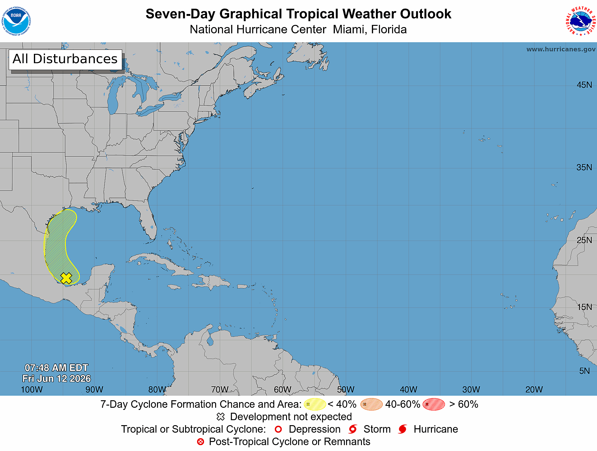
The first area of interest this season has popped up in the southwestern Gulf, posing no threat to Florida.
With a developing El Niño and a potential "Super El Niño," forecast models are calling for a below-average hurricane season this year.
Find out what's happening in Tampafor free with the latest updates from Patch.
Still, all eyes are on this first broad area of low pressure in the Gulf, which has formed over the far southern Bay of Campeche, the National Hurricane Center said.
The system is producing disorganized showers and thunderstorms in the area as of Friday at 8 a.m.
Find out what's happening in Tampafor free with the latest updates from Patch.
Environmental conditions are “only marginally conducive” for the system to strengthen ahead of its projected move inland over eastern Mexico late Saturday or Sunday, the NHC said.
Forecasters also said the system could reemerge over the northwestern Gulf, near Texas, by the middle of next week, either Tuesday or Wednesday.
If this happens, it would interact with a frontal boundary, facing conditions that would hinder development.
The area only has a 10 percent chance of forming a tropical storm or hurricane over the next week, the NHC said.
The slight chance of further development for the system is spurred by expectations that the low will combine with remnants of Tropical Storm Cristina in the Pacific, Florida meteorologist Matt Devitt wrote in a social media post.
Cristina is expected to fall apart after making landfall in Central America with its leftovers moving into the Bay of Campeche, Devitt said.
“*IF* it [the system] does develop, it would be weak. Regardless, rain and flooding are the main issues whether it forms or not for northern Mexico and even parts of South Texas,” he wrote.
If the system does surprise forecasters and develop into the first tropical storm of the season, it would be named Arthur.
Other Florida forecasters watching the system said there’s nothing to worry about, especially in the Sunshine State.
“Our disorganized low in the Bay of Campeche still doesn't look great in terms of development. The blob has changed shape along the Texas coastline, but will take a lot for it to get itself together. Heavy rain still possible for Mexico,” Denis Phillips, chief meteorologist for Tampa Bay 28, wrote in a social media post.
Fox 13’s Paul Dellegatto wrote in a social media post that the area being watched “is a typical spot for early season development.”
Dellegatto added, “Model support at this point is weak.”
While forecasters are calling for a below average hurricane season because of the developing El Niño, which would hinder storm formation, sea surface temperatures in waters near Florida are running above average for this time of year, within the 80-degree range, the threshold generally needed for tropical development, AccuWeather forecasters said.
“While we always monitor the tropics for potential threats, we’ll be keeping a close eye on the central and eastern Gulf and the southwestern Atlantic,” AccuWeather’s lead hurricane expert Alex DaSilva said. “Climatologically, this region can experience early-season tropical development.”
Get more local news delivered straight to your inbox. Sign up for free Patch newsletters and alerts.