Weather
Hurricane Lee Latest: Dangerous Surf, Rip Currents Forecast For U.S.
While Hurricane Lee continues to move through the Atlantic, rainfall and lower temperatures are forecast for Georgia.

GEORGIA — Though weather officials say Monday morning was still "too soon to know" what type of threat Hurricane Lee could have on the U.S. east coast, the National Hurricane Center predicted dangerous surf and rip currents are heading toward the coast this week.
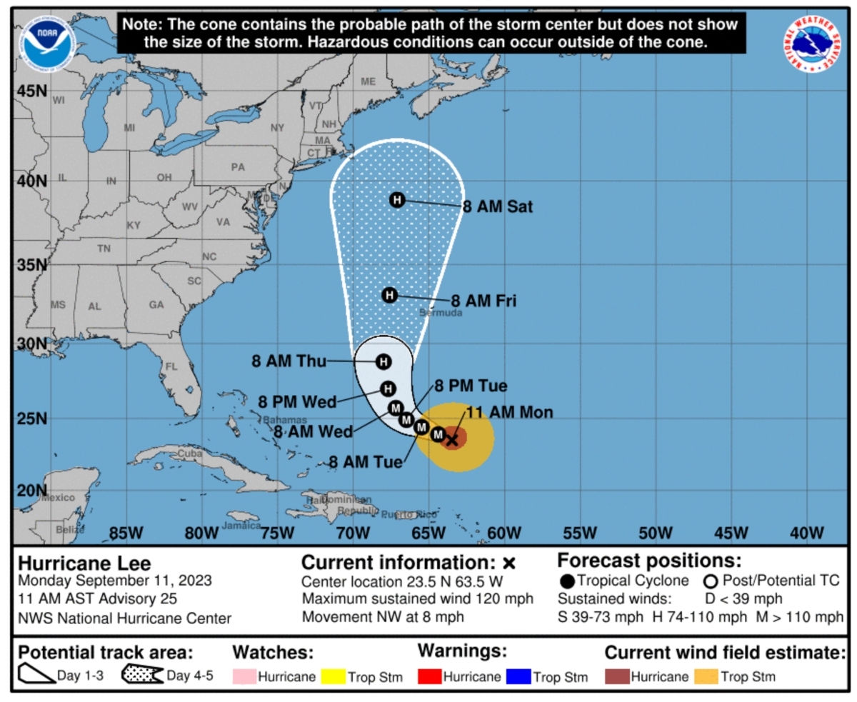
At its 11 a.m. update, the hurricane center said Lee was expected to cause wind, rain and high surf impacts to Bermuda later in the week.
Weather officials also anticipate Lee will bring threatening rip and surf currents to the northern Leeward Islands, the Virgin Islands, Puerto Rico, Hispaniola, the Turks and Caicos Islands and the Bahamas the majority of this week.
Find out what's happening in Across Georgiafor free with the latest updates from Patch.
AccuWeather reported Lee was headed toward the Caribbean and predicted the storm should soon regain strength as its moves over the warm ocean.
The hurricane was a Category 3 storm Monday morning, just days after reaching Category 5 status.
Find out what's happening in Across Georgiafor free with the latest updates from Patch.
The National Weather Service did not have any alerts issued for metro Atlanta or Savannah. The weather service repeatedly told Patch last week that Lee should not be a concern for Georgia.
Temperatures for the metro are forecast to cool down this week, giving the area a break from scorching high-90 degree temperatures in recent weeks. Lows throughout the week are expected to be in the 60s.
The weather service anticipates a chance for thunderstorms Monday through Wednesday.
At 3:30 p.m., the weather service predicted the following forecast for metro Atlanta:
This Afternoon: A 20 percent chance of showers and thunderstorms. Sunny, with a high near 88. Northwest wind around 5 mph becoming calm.
Tonight: A 10 percent chance of showers and thunderstorms before 8pm. Mostly clear, with a low around 69. Southeast wind around 5 mph.
Tuesday: A 30 percent chance of showers and thunderstorms, mainly after 2 p.m. Mostly sunny, with a high near 87. Light and variable wind becoming west 5-10 mph in the morning.
Tuesday night: A 30 percent chance of showers and thunderstorms, mainly before 8 p.m. Partly cloudy, with a low around 68. West wind around 5 mph becoming north in the evening.
Wednesday: A 20 percent chance of showers and thunderstorms after 2 p.m. Partly sunny, with a high near 83. Northwest wind 5-10 mph.
Wednesday night: A 10 percent chance of showers and thunderstorms before 8 p.m. Partly cloudy, with a low around 65.
Thursday: A 20 percent chance of showers and thunderstorms after 2 p.m. Mostly sunny, with a high near 81.
Thursday night: A 10 percent chance of showers and thunderstorms before 8 p.m. Partly cloudy, with a low around 63.
Friday: Mostly sunny, with a high near 81.
Friday night: Mostly clear, with a low around 61.
Saturday: Sunny, with a high near 83.
Saturday night: Partly cloudy, with a low around 63.
Sunday: A 20 percent chance of showers and thunderstorms. Mostly sunny, with a high near 82.
Get more local news delivered straight to your inbox. Sign up for free Patch newsletters and alerts.