Weather
GA Ice Totals Revealed After Winter Storm Kills 22
Forecasters say they are eyeing another snowstorm that could target the East and Gulf coasts this weekend.

Updated 2:10 p.m.
Residents will not get a reprieve from the frigid temperatures this week after a deadly winter storm killed dozens of people in the U.S. and caused more than 20,000 power outages.
This comes amid a report of another snowstorm that could blast the Gulf and the East Coast this weekend.
Find out what's happening in Atlantafor free with the latest updates from Patch.
According to ABC News, the widespread system is to blame for at least 22 deaths across the U.S. Thousands of flights reportedly remained canceled, and more than 700,000 people did not have electricity across the nation.
In Georgia, temperatures began to plummet on Saturday, but Sunday brought the main threat of freezing rain that caused slick roads.
Find out what's happening in Atlantafor free with the latest updates from Patch.
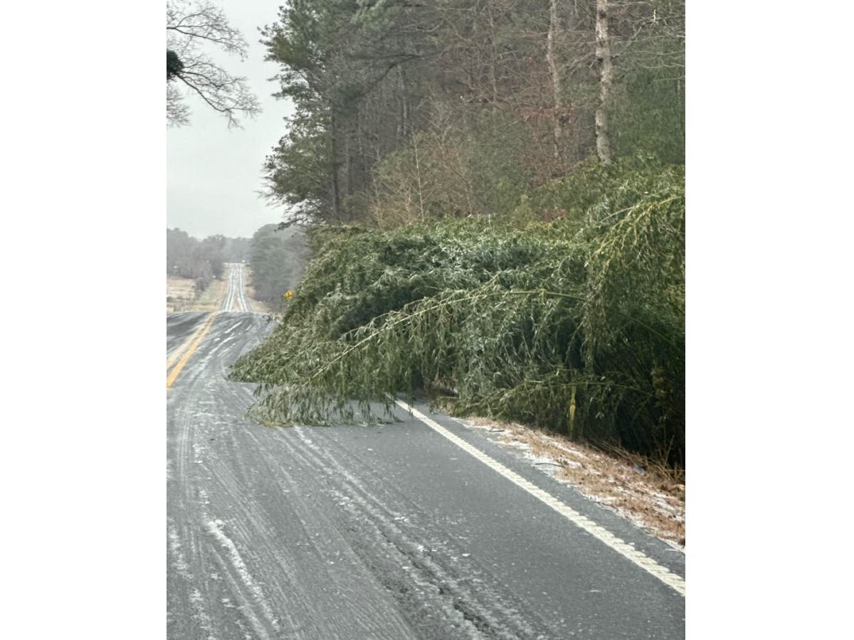
Authorities reported downed trees and several road closures after the storm largely chilled the northern and central portions of the state.
White County was among the harder-hit areas, receiving a half-inch ice accumulation, National Weather Service meteorologist Ryan Willis told Patch.
Forsyth and Gwinnett counties saw ice accumulations of a quarter of an inch to four-tenths of an inch, while a 10th of an inch to a quarter of an inch of ice built up in the heart of metro Atlanta, he said.
The latter included DeKalb, Cobb and Fulton counties. Sleet fell in areas near Hall, Gwinnett and Clarke counties.
Schools closed, and state workers were ordered to stay home. President Donald Trump, at Gov. Brian Kemp's request, approved an emergency declaration for Georgia.
The Georgia Department of Public Safety on Sunday said a commercial vehicle enforcement was hit while escorting brining trucks.
"This is exactly why we ask drivers to stay off the roads when travel isn’t necessary and to slow down and move over for emergency vehicles, tow trucks, and disabled vehicles. ... Our troopers and officers are working in hazardous conditions to prepare roads and protect the public. Failing to slow down, stay alert, or move over puts lives at risk including the people working to keep Georgia’s roads safe," authorities said in Facebook post.
Around 2:11 p.m. Monday, the Georgia outage map at poweroutage.us showed 24,607 homes had no working electricity.
The ice storm warning in Georgia has been lifted, but Kemp's state of emergency remains.
On Monday, roads not frequently traveled were still icy; but, Willis said most roadways had been cleared.
According to Flight Aware data, there were 505 flight delays at Hartsfield-Jackson Atlanta International Airport. Cancellations totaled 268 as of 2:12 p.m. Monday.
Weather officials cautioned against black ice, not easily seen on roadways while traveling. The lingering ice is due to temperatures that will stay below freezing for several hours.
- Slow down and increase your following distance.
- Avoid sudden braking or sharp turns.
- Keep both hands on the wheel and steer gently.
- Use headlights for better visibility.
- Be extra cautious on bridges, overpasses, shaded areas and ramps.
- If you begin to slide, stay calm, ease off the gas and steer in the direction of the skid.
- In an emergency, dial 911.
What Could Georgia Expect This Week?
The NWS issued two cold weather advisories for several counties, including metro Atlanta. One expired at 10 a.m., but the other will take effect at 8 p.m. Monday and will not expire until 9 a.m. Tuesday.
Residents will face "very cold wind chills from -4 to 15 degrees" in Bartow, Cherokee, Forsyth, Hall, Paulding, Cobb, Fulton, Gwinnett, Barrow, Clarke, Oconee, Douglas, DeKalb, Rockdale, Fayette, Clayton and Henry counties, according to the alert.
Wind chills are apparent "feel-like" temperatures and are not the actual temperature, Willis said.
Low temperatures across the Atlanta region will be between 10 degrees and 15 degrees, but the wind chills will make temperatures feel like they are in the single digits on the skin.
High temperatures will rise to the upper 30s to around the 40s by Tuesday afternoon, but they will feel like the low 30s.
Georgians may battle "very cold nighttime temperatures" for the remainder of the week, possibly through Friday, according to a NWS forecast.
Could Georgia Get A Third Winter Storm?
Willis said while more colder air will return by the weekend, as of Monday afternoon, there was not a significant threat for wintry precipitation in Georgia. However, he added it is "worth watching" for more precipitation.
Contrastingly, AccuWeather reported a snowstorm could set its sights on the East Coast. The private weather company forecasted snow, strong winds and rain for Georgia this weekend.
"As early as Friday, precipitation could begin along the Gulf Coast. Rain is most likely south of Interstate 10 from Louisiana to Florida. Depending on exactly when the storm strengthens, snow could mix with rain from Interstate 10 on northward across in parts of Louisiana, Mississippi, Alabama and Georgia," AccuWeather reported.
Though the storm has the possibility of being more intense than the one from this past weekend, forecasters say it could have less coverage area.
AccuWeather noted there are two likely scenarios with the impending snowstorm.
The first concept is that the storm will transition into a weakened system that moves along the Gulf Coast and over the Atlantic Ocean before heading northward. If this happens, New England and the Carolinas could be covered in snow.
If it turns northward, snow could trek across the Eastern Seaboard. A nor'easter would mean heavy snow for the mid-Atlantic.
This all comes after Georgia faced two back-to-back winter storms across two weekends.
For now, here is the National Weather Service's detailed forecast for metro Atlanta:
This Afternoon: Sunny, with a high near 32. Northwest wind around 15 mph, with gusts as high as 30 mph.
Tonight: Clear, with a low around 15. Northwest wind 10-15 mph, with gusts as high as 25 mph.
Tuesday: Sunny, with a high near 39. West wind 5-10 mph, with gusts as high as 20 mph.
Tuesday Night: Partly cloudy, with a low around 25. Northwest wind around 5 mph, with gusts as high as 15 mph.
Wednesday: Mostly sunny, with a high near 43. Northwest wind 5-10 mph, with gusts as high as 15 mph.
Wednesday Night: Mostly clear, with a low around 26.
Thursday: Partly sunny, with a high near 43.
Thursday Night: Mostly cloudy, with a low around 27.
Friday: Partly sunny, with a high near 40.
Friday Night: A slight chance of rain and snow showers. Mostly cloudy, with a low around 17. Chance of precipitation is 20 percent.
Saturday: Mostly sunny, with a high near 27.
Saturday Night: Mostly clear, with a low around 16.
Sunday: Sunny, with a high near 36.
Get more local news delivered straight to your inbox. Sign up for free Patch newsletters and alerts.