Weather
Federal Disaster Declaration Issued For GA As Major Winter Storm Moves In
GA's worst ice storm in 12 years has caused school cancellations and a state of emergency. Travel conditions will be impossible at times.

Updated at 8:56 p.m.
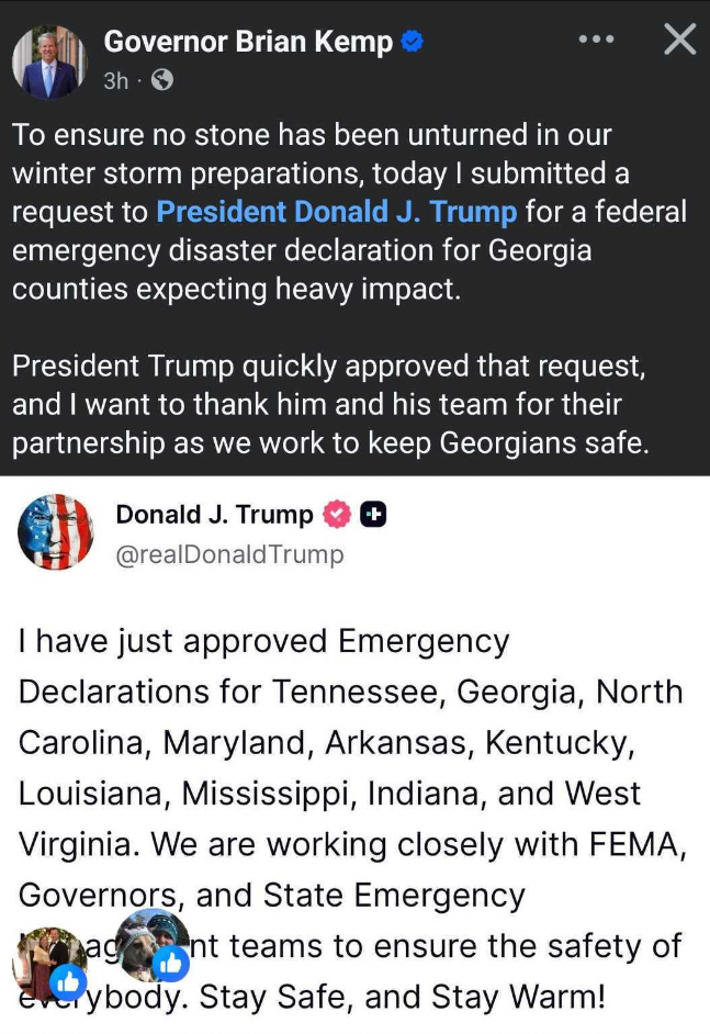
Georgia Gov. Brian Kemp reached out to President Donald Trump as a powerful winter storm was set to pummel the area.
"To ensure no stone has been unturned in our winter storm preparations," he said, "today I submitted a request to President Donald Trump for a federal emergency disaster declaration for Georgia counties expecting heavy impact."
Find out what's happening in Atlantafor free with the latest updates from Patch.
He continued: "President Donald Trump quickly approved that request, and I want to thank him and his team for their partnership as we work to keep Georgians safe."
Trump posted on Truth Social that he had "just approved Emergency Declarations for Tennessee, Georgia, North Carolina, Maryland, Arkansas, Kentucky, Louisiana, Mississippi, Indiana, and West Virginia. We are working closely with FEMA, Governors and State Emergency management teams to ensure the safety of everybody. Stay Safe and Stay Warm!"
Find out what's happening in Atlantafor free with the latest updates from Patch.
The outage tracker site PowerOutage.Us showed that as of 9:20 p.m. Saturday there were 1,438 customers in Georgia without electricity.
Updated at 7:30 p.m.
As a major winter storm moves into Georgia Saturday night, an ice warning remains in effect and forecasters warn of impossible travel conditions at times, along with the possibility of widespread power outages as a state of emergency continues.
An ice storm warning has been expanded to include metro Atlanta and surrounding areas, putting more residents on notice about a powerful, dangerous system heading Georgia's way this weekend. The warning is in effect from 1 p.m. Saturday to 10 a.m. Monday, the National Weather Service said.
While Atlanta seems more likely to see rain rather than ice, counties north of the city should see ice.
The National Weather Service posted this message Saturday evening: "To dispel any confusion: WE ARE STILL FORECASTING SIGNIFICANT ICE ACCUMULATIONS BEGINNING OVERNIGHT TONIGHT, AND AN ICE STORM WARNING REMAINS IN EFFECT. The magenta oval highlights areas we're unsure will warm enough to see chances for thunderstorms Sunday afternoon."

Portions of east central, north central, northeast, and northwest Georgia should see total ice accumulations between a quarter of an inch and one inch. Winds gusting as high as 40 mph are forecast, the agency said Saturday night.
"We are still forecasting significant and potentially crippling ice accumulations across portions of north and northeast Georgia through Sunday night. An ice storm warning is in effect for nearly all areas along and north of I-20 until Monday," the NWS said. "What remains to be seen is how much we warm tomorrow afternoon. If the cold air retreats further north, we could see the chance for thunderstorms extend as far north as the dark green shaded area. If the cold air lingers, or extends further south than we currently expect, areas within the magenta oval will likely be too cold and stable to see thunderstorms or severe weather."
"Expect power outages and tree damage due to the ice," the NWS said. "Travel could be impossible. The hazardous conditions will impact the Monday morning commute.
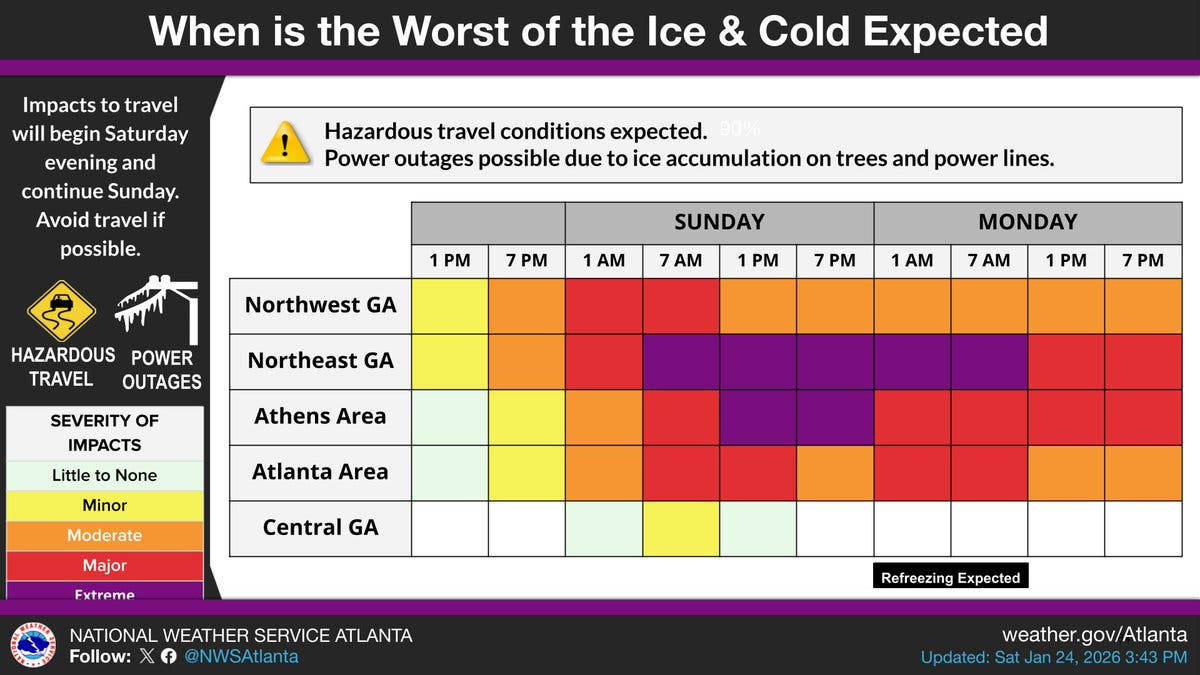
A new timeline released Saturday afternoon for the anticipated ice and cold impacts in Georgia indicated that the worst is expected between 7 a.m. Sunday to 7 a.m. Monday in northeast Georgia and from 1 p.m. Sunday to 7 p.m. Sunday in the Athens area, the NWS said.
"Extreme to major impacts are expected in northeast GA," the NWS said. "Stay safe out there, everyone."
The NWS also sent out a message on social media to clarify some points: "There has been a lot of (valid) confusion regarding our previous post about tomorrow's conditional severe weather threat across portions of central Georgia — we hear you," the NWS said.
The NWS urged residents to continue to take necessary precautions to finalize preparations for the significant ice accumulations expected overnight Saturday, if they haven't already.
"We sincerely apologize for any confusion, but we want to make sure residents within the yellow shaded area realize that there is a chance for them to see a damaging wind gust (and perhaps a tornado) while areas further north are dealing with an ice storm," the NWS said.
The NWS urged residents facing the ice storm to take heed.
"Significant icing expected. Total ice accumulations between a quarter of an inch and one inch are expected. Winds gusting as high as 40 mph," the NWS office in Atlanta posted Saturday morning.
The warning covers portions of east central, north central, northeast, and northwest Georgia, including the Atlanta metro.
"The worst conditions in northwest Georgia will occur today and tonight," the NWS said Saturday. "For northeast Georgia & Atlanta, Sunday will be treacherous!"
On Saturday afternoon, the NWS released a graph indicating

Significant impacts and travel disruptions are expected from this weekend's ice storm, and due to the cycle of melting and re-freezing, may continue to some degree into next week. Conditions are likely to be worst Sunday into Monday morning for all affected areas, according to the weather service.
The ice warning includes Pickens, Bartow, Cherokee, Forsyth, Hall, Polk, Paulding, Cobb, Fulton, Gwinnett, Barrow, Clarke, Oconee, Oglethorpe, Wilkes, Douglas, DeKalb, Rockdale, Walton, Newton, Morgan, Greene, Taliaferro, Clayton, Henry and Warren counties.
Power outages could last for up to five days in some areas, NWS meteorologist Laura Belanger told Patch. In some metro Atlanta counties, such as Gwinnett County, she said those residents could be left in the dark for up to three days.
This is because ice on the roads will make it difficult for crews to tend to utility lines. Due to bitter temperatures, ice may not melt until Tuesday morning, the weather service said.
Travel should be restricted to emergencies only, authorities said.
"If you must travel, keep an extra flashlight, food and water in your vehicle in case of an emergency. Prepare for extended power outages. The latest road conditions for the state you are calling from can be obtained by calling 511."
Emergency management officials said Friday that this is the first ice storm warning for Georgia in 12 years.
"That is a lot of ice," said Will Lanxton, state meteorologist with the Georgia Emergency Management and Homeland Security Agency at a Friday news conference. "That is going to do a lot of damage to trees and power lines. Travel is going to be difficult to impossible for most areas."
Residents living in the ice storm warning area may not be able to travel between Saturday afternoon and Monday morning, he said.
"It's been 12 years since we've had an ice storm warning in Georgia, so this is not a product that we see issued every year," Lanxton said. "It's pretty rare, so I think that indicates the confidence in the forecast for this event and the need to take it very seriously."
Gov. Brian Kemp has declared a state of emergency, activated the State Operations Center and has put 500 members of the Georgia National Guard on standby for storm recovery.
Here is the latest Atlanta forecast from the NWS:
Saturday: A 10 percent chance of showers after 5pm. Mostly cloudy, with a high near 43. East wind around 15 mph, with gusts as high as 25 mph.
Saturday Night: Rain showers before 1am, then freezing rain, possibly mixed with sleet between 1am and 2am, then freezing rain after 2am. Low around 29. East wind around 15 mph, with gusts as high as 25 mph. Chance of precipitation is 100%. New ice accumulation of 0.1 to 0.3 of an inch possible. Little or no sleet accumulation expected.
Sunday: Freezing rain before 10am, then rain or freezing rain between 10am and 1pm, then rain showers after 1pm. High near 39. East wind 10 to 15 mph, with gusts as high as 25 mph. Chance of precipitation is 100%. New ice accumulation of 0.1 to 0.2 of an inch possible.
Sunday Night: Showers likely, mainly before midnight. Mostly cloudy, with a low around 24. West wind 10 to 15 mph, with gusts as high as 30 mph. Chance of precipitation is 60%.
Monday: Sunny, with a high near 33. Northwest wind 15 to 20 mph, with gusts as high as 30 mph.
Monday Night: Mostly clear, with a low around 15.
Tuesday: Sunny, with a high near 38.
What Could Georgia Expect With Ice Storm?
The storm will stretch itself across the southern and eastern U.S., with AccuWeather reporting 200 million will be affected.
"It is rare that storms combine this much snow, ice and bitter cold over such a large area," AccuWeather Senior Vice President Evan Myers said in a report.
Wintry precipitation expanded across the central United States as the storm intensified. Snow is most widespread from Tennessee through Oklahoma and Kansas, with accumulations of 6 inches reported near Little Rock, Arkansas, and in central Kansas, AccuWeathersaid Saturday morning. The worst of the sleet and ice was focused on a zone from central Texas into Arkansas and northern Mississippi, including the Dallas-Fort Worth region.
AccuWeather cautioned flights could be a problem for anyone looking to travel by plane.
“Air travel will likely be a nightmare this weekend into early next week," AccuWeather Chief Meteorologist Jonathan Porter said. "Travel chaos may ensue, making it very challenging for air passengers to make their way to their destinations, perhaps for days on end, as the US air system is impacted by the major storm and then begins the slow recovery process."
Lanxton said Tuesday should bring the coldest temperatures in years for Georgia.
"Tuesday morning is going to be brutal cold," he said. "Obviously, anything that remains on Tuesday morning is also going to be frozen."
He added if road moisture is not dry by Monday morning, it will freeze and make commuting challenging.
How Is Georgia Preparing?
As the storm nears, time is running out to get ready for it.
People should finish their preparations by Saturday afternoon, which is the "no-go line," at the latest, GEMA/HS Director Josh Lamb said during Friday's state news conference.
"For all the work that GEMA and our state partners are doing to prepare for the winter storm, the best help we can get is for individuals to prepare for themselves," he said.
The Georgia Department of Transportation began brining and treating roadways between midnight and early Saturday morning in areas north of Interstate 20.
Other agencies on standby include the Georgia State Patrol, the Georgia Forestry Commission and the Georgia Department of Agriculture.
Gov. Brian Kemp said he has been in contact with Georgia Power, which has stated it is fully ready for the storm.
Georgia Power on Friday said it is suspending disconnections for all unpaid utility bills until Thursday, when disconnections will resume.
The statewide power company advised the following tips for customers:
Before the storm
- Make a plan and check on loved ones.
- Build or update your emergency kit.
- Use generators safely—never indoors.
After the storm
- Slow down and move over for utility crews.
- Stay far away from downed power lines.
- Never pull tree limbs off of power lines yourself.
Thank you to the great road crews working throughout the weekend to help keep Georgians safe! Help them do their jobs by staying off the roads as much as you can during this winter storm. https://t.co/UpZkcySWmr
— Governor Brian P. Kemp (@GovKemp) January 23, 2026
As bridges and overpasses are the first to freeze, Lamb suggested people carefully drive on them. He also advised people have emergency car kits that include ice scrapers, snacks, portable battery chargers and other crucial items.
Residents may want to have enough nonperishable food and medication for at least three days in the case of power outages. Lamb also encouraged they have emergency preparedness plans and a safe way to heat homes that do not include the oven or having portable generators indoors.
People should keep their pets inside as much as possible and have a way to charge their phones, Lamb said.
Georgia officials have been in contact with the Georgia Department of Public Health to ensure nursing homes know how to seek assistance.
Lamb spoke against panic buying, asking people to purchase only what is needed.
With still quite a bit of time before the storm, Belanger advised people "don't wait too long" in making their preparations. Tips she provided included knowing where warm shelter locations are and notifying a family member or friend where you are staying if not at home.
"Once things get going, you’re not going to want to be venturing out," she said.
The Georgia Emergency Management and Homeland Security Agency offers tips for before and during winter weather.
Updates will be posted on the weather service's Twitter page, the weather service's Facebook page and its website.
What About Schools?
On Friday, DeKalb County and Fulton County school districts announced their operational plans for Monday. DeKalb planned to close all of its schools, while Fulton chose to have an asynchronous learning day.
Cobb County Schools, DeKalb County Schools, Atlanta Public Schools, Marietta City Schools and Douglas County Schools have all canceled or rescheduled their weekend event schedules due to the weather threat.
This also includes Bartow County Schools, Paulding County Schools, City Schools of Decatur, Fulton County Schools and Cherokee County Schools.
The University of Georgia encouraged students to leave their residence halls and return home after classes end Friday.
"Given the latest forecasts, we anticipate being closed on Monday. However, we are continuing to monitor conditions and will provide an update to the UGA community early Sunday afternoon regarding our status for Monday, Jan. 26," UGA officials said in a news release.
For any students that remain on campus, the university said it will keep its residence halls open. However, officials warned there may be power outages and water line breaks, leaving staff to move students to "a limited number of temporary housing areas with emergency heat and meal services."
Dining halls will operate normally, and campus transit shuttles will offer regular service as long as weather conditions permit, UGA officials said.
"There is no time like the present to prepare for the potential impact of the storm this weekend," officials said in the release.
Emory University will close its campus on Saturday and Sunday. This includes the university's Oxford College, sporting events and classes.
University employees will work remotely, and other essential personnel were asked to contact their supervisors for guidance.
"Emory Healthcare employees should refer to communications from EHC for information," university officials said.
The Atlanta University Center Consortium will also close its campuses on Saturday and Sunday. The AUC consists of Clark Atlanta University, Morehouse College, Morehouse School of Medicine and Spelman College.
RELATED:
Get more local news delivered straight to your inbox. Sign up for free Patch newsletters and alerts.