Weather
Dime-Sized Hail, 60MPH Winds Loom With Severe GA Storms
A Level 2 slight risk for severe storms was issued in a portion of Georgia while scorching heat could blaze through other areas. See where.

Severe storms could rush dime-sized hail and up to 60 mph winds into Georgia on Friday, prefacing a rain pattern that could threaten weekend plans.
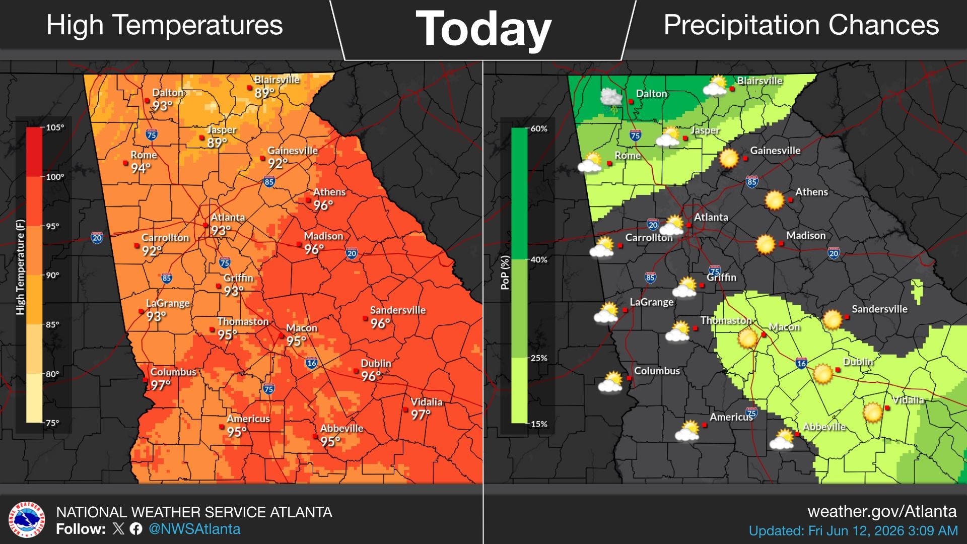
The National Weather Service has issued a Level 2 slight risk for severe storms in far north Georgia, and a Level 1 marginal risk for Rome, Jasper, Dalton and Gainesville.
While metro Atlanta will be spared Friday, the area is not expected to escape the rain in coming days.
Find out what's happening in Atlantafor free with the latest updates from Patch.
There are daily storm chances in metro Atlanta, starting Saturday and lasting through Thursday. It was not immediately know if the storms will become severe.
.jpg)
But, before then, Georgia will heat up across the state. Residents in "Hotlanta" are expected to face a high of 93 degrees Friday.
Find out what's happening in Atlantafor free with the latest updates from Patch.
Areas further south could near triple-digit temperatures.
The high temperatures could linger through Saturday, making for a hot day for those attending 2026 FIFA World Cup watch parties. The World Cup will bring matches to Atlanta, starting Monday.
Here is the National Weather Service's Friday afternoon forecast for metro Atlanta:
This Afternoon: Mostly sunny, with a high near 93. Heat index values as high as 98. West wind 5-10 mph.
Tonight: Partly cloudy, with a low around 74. West wind around 5 mph.
Saturday: A 10 percent chance of showers and thunderstorms after 5 p.m. Mostly sunny, with a high near 92. Heat index values as high as 98. Northwest wind around 5 mph.
Saturday Night: A slight chance of showers and thunderstorms between 7 p.m. and 11 p.m., then a slight chance of showers after 11 p.m. Partly cloudy, with a low around 74. West wind around 5 mph becoming calm in the evening. Chance of precipitation is 20 percent.
Sunday: A chance of showers, then showers and thunderstorms likely after 11 a.m. Mostly sunny, with a high near 89. West wind 5-10 mph, with gusts as high as 20 mph. Chance of precipitation is 70 percent.
Sunday Night: Showers and thunderstorms likely before 11 p.m., then a chance of showers between 11 p.m. and 2 a.m. Mostly cloudy, with a low around 71. Chance of precipitation is 60 percent.
Monday: Showers likely and possibly a thunderstorm, mainly after 2 p.m. Mostly cloudy, with a high near 83. Chance of precipitation is 60 percent.
Monday Night: Showers likely and possibly a thunderstorm. Mostly cloudy, with a low around 67. Chance of precipitation is 60 percent.
Tuesday: A chance of showers, with thunderstorms also possible after 2 p.m. Mostly cloudy, with a high near 80. Chance of precipitation is 50 percent.
Tuesday Night: A 30 percent chance of showers and thunderstorms, mainly after 2 a.m. Mostly cloudy, with a low around 65.
Wednesday: A 40 percent chance of showers and thunderstorms. Partly sunny, with a high near 83.
Wednesday Night: A 30 percent chance of showers and thunderstorms. Partly cloudy, with a low around 69.
Thursday: Showers and thunderstorms likely. Mostly cloudy, with a high near 86. Chance of precipitation is 60 percent.
Updates will be posted on the weather service's Twitter page, the weather service's Facebook page and its website.
Get more local news delivered straight to your inbox. Sign up for free Patch newsletters and alerts.