Weather
Hurricane Irma: Georgia Evacuation Order For 540K Residents; Prepare Now
The path of deadly Hurricane Irma should take it over Georgia on Monday, 30 counties are under a state of emergency, and how to prepare.

Mandatory evacuations for half a million people will begin Saturday for the Savannah area as deadly Hurricane Irma, the most powerful Atlantic storm ever recorded, continues on a projected path that could take the strong Category 5 storm across Georgia on Monday, forecasts say. To help ease highway congestion, Georgia DOT will suspend construction lane closures on interstates and secondary routes south of I-20 this weekend. The storm is blamed for at least 10 deaths so far and was following a path that may have dire implications for Florida, coastal Georgia and the Carolinas.
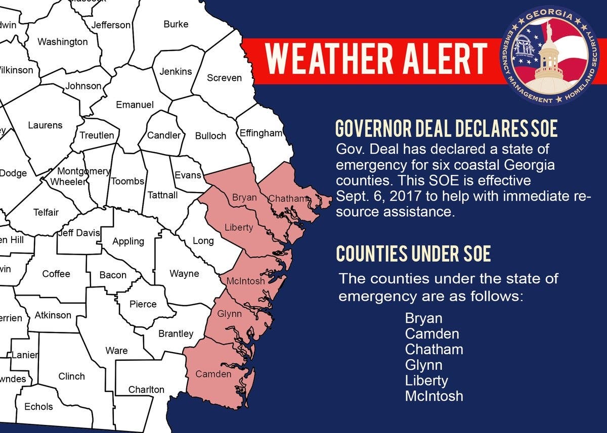
On Thursday, Gov. Nathan Deal added 24 Georgia counties to the six on the coast that were already under a state of emergency, and Georgians were urged to prepare for strong winds, rain and flooding. Atlanta Motor Speedway is open to campers who need a place to stay, while the metro's hotels are nearly full of people fleeing the storm.
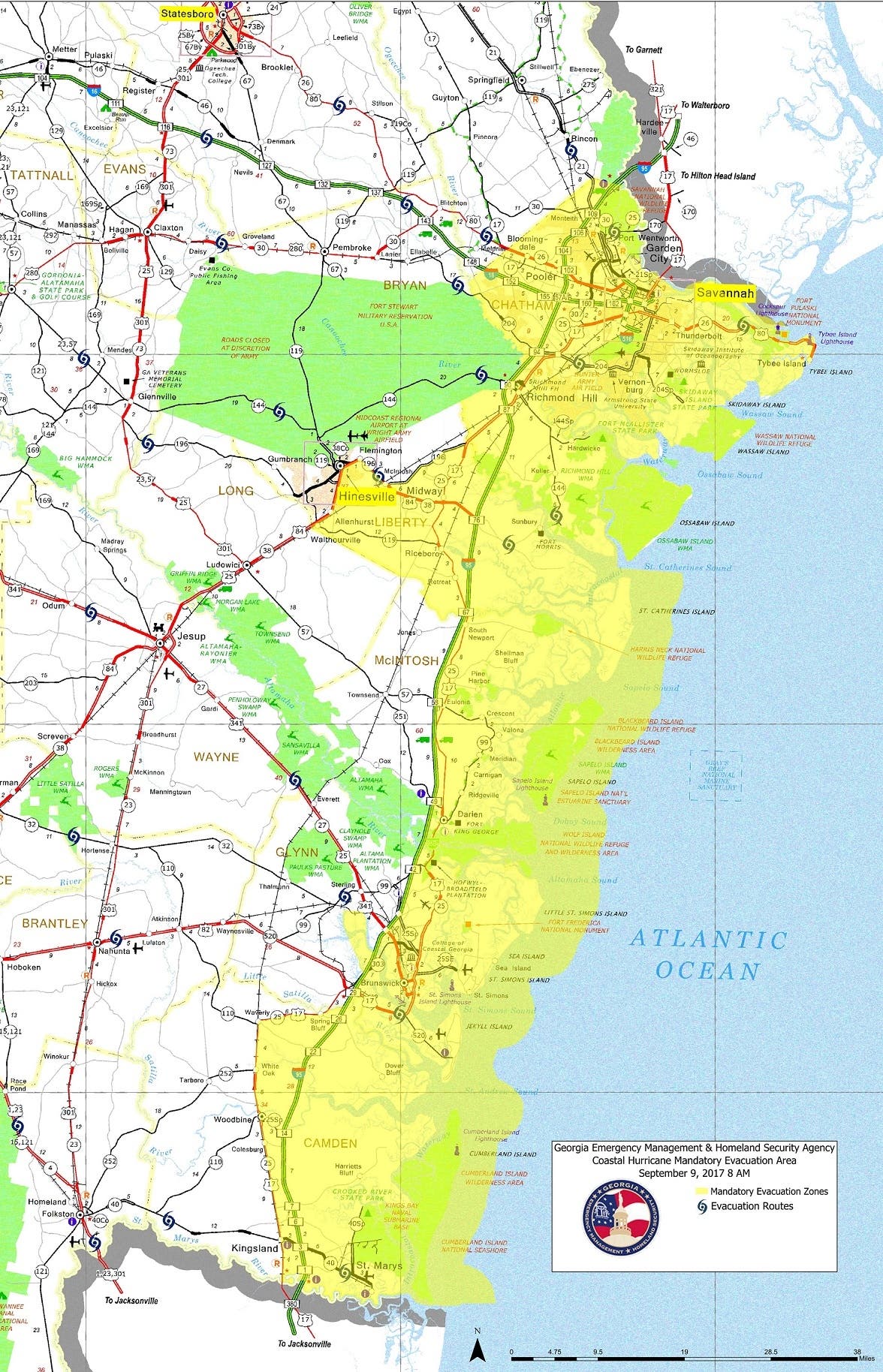
While the storm's exact path is impossible to predict, the National Hurricane Center has the storm jogging a bit eastward, making a hit somewhere between Cumberland Island and Savannah more of a possibility. At that point, after pummeling the Orlando area, Irma is likely to have weakened a bit to a Category 3 storm when it comes ashore in Georgia. The center's forecast map shows a probable path for Irma that engulfs the entire Florida and Georgia coastlines and stretches up into the South Carolina Lowcountry region. Chatham County, Georgia's most populous coastal county that includes Savannah, emergency management director Dennis Jones warned Irma could bring 15 feet of storm surge and force floodwaters up the Savannah and Ogechee Rivers, potentially swamping 60 percent of the county.
Find out what's happening in Atlantafor free with the latest updates from Patch.
Even the Atlanta area could be affected by the storm's bands of rain, and tropical storm-strength winds could make their way into south Georgia by 8 a.m. Sunday. Residents in all of Florida's 67 counties have been urged to prepare to evacuate, and multiple forecast models show the storm working its way into Georgia after striking Florida — if not jogging up the coast and eventually making landfall somewhere in the Peach State. (Get Patch's Daily Newsletter and Real Time News Alerts. Or, if you have an iPhone, download the free Patch app.)
Watch: Deaths, Destruction Reported As Hurricane Irma Heads Toward Florida
Find out what's happening in Atlantafor free with the latest updates from Patch.
Deal expanded his emergency declaration to a total of 30 counties now included in a state of emergency and issued a mandatory evacuation order for all areas east of Interstate 95, all of Chatham County and some areas west of I-95 that could receive a storm surge from Hurricane Irma. The executive order also authorized up to 5,000 Georgia National Guard members to be on state active duty to support Hurricane Irma response and recovery. The state of emergency prohibits price gouging for all goods and services related to the storm.
Traffic was already heavy on Interstate 75 to Atlanta by Thursday afternoon with evacuees pouring out of Florida. Forecasts called for Irma's center to reach the Georgia-Florida line by Monday morning, though the storm's exact path and intensity remained uncertain.
Panic over #HurricaneIrma Mass of drivers on #I95 in #Florida looking for safety. #HuracanIrma #irma #FloridaKeys #Miami #Caribbean pic.twitter.com/ol89VUgV8L
— Hurricane Info (@HurricaneData) September 7, 2017
“The state is mobilizing all available resources to ensure public safety ahead of Hurricane Irma,” said Deal. “I encourage all Georgians in our coastal areas that could be impacted by this storm to evacuate the area as soon as possible. Beginning Saturday, a mandatory evacuation order will take effect for Chatham County, all areas east of I-95 and some areas west of I-95 that could be impacted by this catastrophic hurricane and storm surge. … Finally, I ask all Georgians to join me in praying for the safety of our people and all those in Hurricane Irma’s path.”
The 30 counties under a state of emergency are Appling, Atkinson, Bacon, Brantley, Bryan, Bulloch, Burke, Camden, Candler, Charlton, Chatham, Clinch, Coffee, Echols, Effingham, Emanuel, Evans, Glynn, Jenkins, Jeff Davis, Liberty, Long, McIntosh, Pierce, Screven, Tattnall, Toombs, Treutlen, Wayne and Ware.
In Chatham County, emergency management director Dennis Jones said, "What we saw during Matthew could exponentially increase." Jones held out the possibility that Irma could strike Georgia as a Category 3 or greater hurricane. The last storm that powerful to make landfall along the Georgia coast arrived in 1898.
Deal and the State Operation Command Team will hold a news conference Friday morning at 10 a.m. to provide updates on storm preparations. A livestream of the conference will be available here.
Normally I-16 carries traffic in both directions between Macon and Savannah, but on Saturday at 8 a.m., the drop gate barricades will be lowered to keep traffic off the interstate that would be headed to areas under a mandatory evacuation.
"Our main threat will be gusty winds and, depending on that track, we could be dealing with flooding or tornadoes," Lauren Merritt, a meteorologist with the National Weather Service office in Peachtree City, told Patch. "We'll definitely get rainfall for sure and some gusty winds, but the extent to which is still a little bit uncertain at this time."

The Atlanta Humane Society took in about 100 animals Thursday from shelters in St. Cloud, Florida, as Hurricane Irma threatens the Sunshine State. The agency sent two transport vehicles to Osceola County Animal Services in Florida to pick up the animals from their shelter, AHS spokeswoman Christine Hill told Patch. In recent days, the Atlanta Humane Society has been busy assisting in the effort to save displaced animals in Hurricane Harvey's wake. Days ago, the facility took in 30 dogs and cats from the Louisiana SPCA and placed them in Alpharetta at its Mansell campus.
By 5 p.m. Thursday, the eye of Hurricane Irma was moving west-northwest off the Dominican Republic's northern coast, according to the National Hurricane Center. The storm had top sustained winds near 175 mph and is expected to continue moving between Hispaniola and the Turks and Caicos, on a course taking it to the southeastern Bahamas on Thursday evening, where storm surges of up to 20 feet are possible, the hurricane center said.. Hurricane-force winds reach some 70 miles from the eye of the storm, and tropical storm-force winds reach 185 miles from the eye, the weather service said
With many state highways expected to be congested with traffic from Florida and coastal Georgia evacuees, Georgia DOT will halt construction-related lane closures on interstates and secondary routes south of I-20. However, projects north of I-20 will continue this weekend. Suspension of lane closures will begin at noon Friday until 7 p.m. on Tuesday, Sept. 12. Major projects of interest that will resume this weekend include the I-285 at Atlanta Road project, North Express Lanes and the Transform 285/400 improvement project; which is dedicated to help reduce traffic congestion and enhance safety near the I-285/SR 400 interchange in metro Atlanta.
The Georgia Department of Transportation said the I-75 South Metro express lanes schedule starting about 20 miles outside Atlanta in McDonough has been changed due to heavy traffic on I-75 northbound from travelers fleeing Irma. "The northbound lanes reversal will be begin at 7:30 p.m. instead of 11:00 p.m.," the agency said. "The lanes will remain in the northbound direction until further notice to accommodate the evacuee traffic."
Rep. Barry Loudermilk from Bartow County urged residents to fill up their gas tank and have food and water on hand. "Our thoughts and prayers are with those impacted, and the military personnel and first responders working to keep everyone safe."
Other Federal, State, and Local Resources for Storm Updates
- National Weather Service Atlanta on Twitter- @NWSAtlanta
- Georgia Emergency Management & Homeland Security Agency-http://www.gema.ga.gov/
- Georgia EM&HS on Twitter- @GeorgiaEMA
- Cherokee County Emergency Management Facebook- https://www.facebook.com/CherokeeEMA/
Disaster Relief Organizations
- The American Red Cross- http://www.redcross.org/
- Georgia Baptist Disaster Relief- https://missiongeorgia.org/georgia-disaster-relief/
- The Salvation Army- https://disaster.salvationarmyusa.org/
- Samaritan’s Purse- https://www.samaritanspurse.org/
DeKalb County officials are urging residents to sign up for an emergency communications system as Hurricane Irma veers dangerously close to Georgia. Residents should sign up for CodeRED, a system used to call, email or text in the event of an emergency or severe weather warning, the county said. Sign up at www.dekalbcountyga.gov by clicking CodeRED at the top of the home page.
As Florida prepared, the Caribbean experienced Irma’s ravaging effects Wednesday night. The death toll in the Caribbean was up to at least 10 as of Thursday morning, according to ABC News. At least eight people had died in St. Martin and St. Barthelemy, along with others in Barbuda and Anguilla.
In Georgia, hotels early Wednesday were already fully booked as Florida residents made plans to evacuate.
Like the Atlanta Patch on Facebook to get more stories like this in your News Feed.
Emergency agencies along Georgia's coast were mobilizing to prepare for the storm, and state Insurance Commissioner Ralph Hudgens was encouraging residents to make copies of their insurance policies; obtain the insurance company’s phone number; inventory their personal belongings; and keep all of these documents with them should they be forced to leave their homes.
The Atlanta Motor Speedway announced Wednesday it would be opening its campsites for Irma evacuees starting Thursday. The speedway is accustomed to accommodating thousands of campers during its NASCAR events.
And the Georgia National Fairgrounds in Perry said it will open its 350 available stalls Thursday for horses being evacuated from harm's way.
Hurricane Preparation Tips
The Georgia Emergency Management & Homeland Security Agency offers tips to prepare for the storm. You can visit the Ready Georgia website or use the Ready Georgia app to begin your planning.
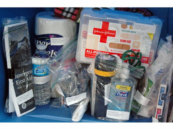
According to ready.gov, every emergency preparedness kit should have the following items:
- Water, one gallon of water per person per day for at least three days, for drinking and sanitation
- Food, at least a three-day supply of non-perishable food (canned food, baby food, granola bars, energy bars)
- Battery-powered or hand-crank radio and a NOAA Weather Radio with tone alert and extra batteries for both
- Flashlight and extra batteries
- First aid kit
- Whistle to signal for help
- Dust mask to help filter contaminated air and plastic sheeting and duct tape to shelter-in-place
- Moist towelettes, garbage bags and plastic ties for personal sanitation
- Wrench or pliers to turn off utilities
- Manual can opener for food
- Local maps
- Cell phone with chargers, inverter or solar charger
Other suggested items to have in your kit include:
- An emergency (reflector) vest
- Red bandanna (in case you need to signal for help)
- Pet supplies (leashes, pet food, medicines, kennel or crate)
- Medications for family members
- Eye drops
- Dry socks
- Cash
- Sleeping bags/blankets
- Writing supplies
- Books/games
- Emergency contact information/documents
- Fire extinguisher
- Waterproof matches/fire starter
- Insect repellant/sun screen
You can find a list of more items and tips on being prepared at ready.gov or the National Hurricane Center.
Make a Communications Plan
If your family isn’t together when a disaster strikes you should know how to reach each other and where to meet up in an emergency. The Ready Georgia app also has an “I AM SAFE” text message tool that allows you to send a text message to emergency contacts in your disaster plan.
Build a Ready Kit
Put together a Ready Kit that includes the supplies you and your family would need for three days. That includes sufficient water, non-perishable food, medications, important documents and any other essential items. Once you’ve gathered all the basic items, consider what unique needs your family might have, such as supplies for pets, seniors or family members with special needs. Add those items to your kit and start packing it today.
Know the location of your local shelter
In the event of an evacuation, have a plan for where you and your family are going. If you plan to go to a local shelter have the address and directions printed out and in your Ready Kit. If you have a pet, check in advance to see if the shelter or hotel you plan to use is pet friendly. Most public shelters can’t accept pets due to health regulations.
Stay informed
Every family should have multiple methods for receiving severe weather alerts, including at least one with an audible alert to wake you in the middle of the night if necessary
There are many options for staying in touch with changing weather conditions:
- NOAA Weather Radio: Watches and Warnings issued by National Weather Service air on these radio.
- Television Stations: Local or national news stations monitor and broadcast weather alerts.
- AM/FM Radio: Radio stations are required to air Emergency Alert System messages.
- Smartphone Apps: Numerous free and paid smartphone applications have been created to notify the public of severe weather. Some of these applications use GPS tracking on your phone and will notify you of severe weather warnings based upon your location. Ready Georgia’s free app provides severe weather alerts and also gives you mobile access to your emergency plan and other preparedness resources.
- Wireless Emergency Alerts: WEA are emergency messages sent by authorized government alerting authorities through your mobile carrier. The alert system doesn’t require you to download an app or subscribe to a service. The WEA message will usually provide the category and time, the agency issuing the alert and what action you should take.
Images via the National Weather Service and KOMUnews via Flickr Commons
Get more local news delivered straight to your inbox. Sign up for free Patch newsletters and alerts.