Weather
Hurricane Isaias: Kemp Issues State Of Emergency
Gov. Brian Kemp urges residents to prepare for Hurricane Isaias, currently a Category 1 storm barreling toward the Southeast.

Updated 5:18 p.m.
Gov. Brian Kemp on Thursday afternoon issued a state of emergency due to the threat of Hurricane Isaias, set to hammer Georgia and other parts of the Southeast.
Shortly after the order was issued, Isaias was upgraded to Category 2 status with 100 mph winds.
Find out what's happening in Atlantafor free with the latest updates from Patch.
A state of emergency permits the state to activate the Georgia Emergency Operations Plan and the Georgia State Operations Center, which Kemp has done. The order coexists with a previous state of emergency that is set to expire on Nov. 5 and was issued to suspend the state gas tax.
Additionally, up to 500 Georgia National Guard troops have been called for duty to help with preparation, response and recovery efforts, Kemp said.
Find out what's happening in Atlantafor free with the latest updates from Patch.
The order will expire at 11:59 p.m. Thursday, Oct. 15, if not extended. (See the full order.)
"As we always do with weather events, we’re hoping for the best but preparing for the worst," he said. "I encourage all Georgians to take this storm seriously and prepare now by stocking up on food, batteries, flashlights, water and other necessities in case of severe weather impacting communities Friday night through Saturday."
RELATED:
- Here's Storm Preparedness Tips Ahead Of Hurricane Isaias In GA
- Event Changes To Know In GA As Hurricane Isaias Nears Southeast
Hurricane Isaias Targets Southeast
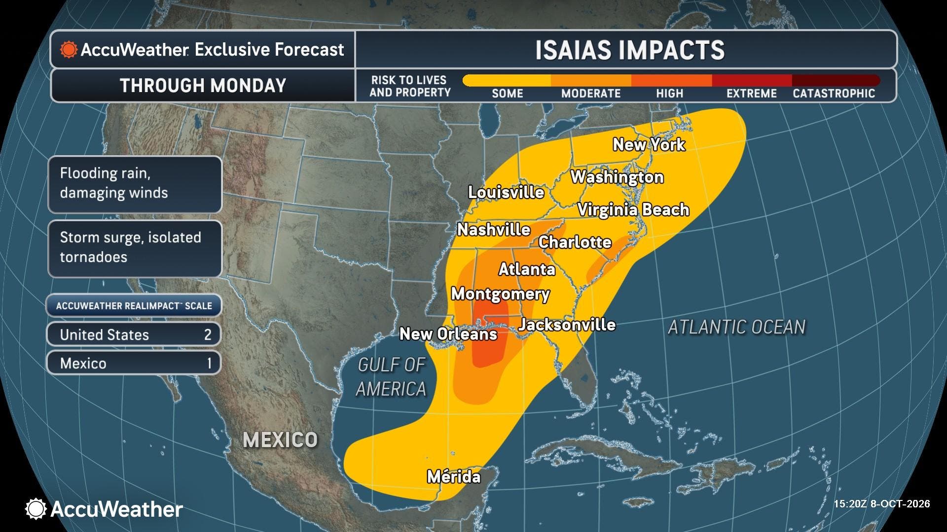
With Isaias set to make landfall and pound the Southeast, Georgia forecasters have issued a flood watch and tropical storm watch ahead of the menacing storm.
A high wind watch will also take effect in Georgia after Isaias, the first hurricane to form during the 2026 Atlantic storm season, tramples the Southeast.
As of the National Hurricane Center's 10 a.m. update, Isaias was situated about 325 miles south of the Mississippi River and had maximum wind speeds of 100 mph.
The current Category 2 system will lose power as it hits Alabama's core as a tropical storm early Saturday morning, the National Weather Service on Thursday told Patch.
However, Isaias was expected to reach Category 2 status upon making landfall Friday evening near Gulf Shores or Pensacola, Florida, according to the Georgia Emergency Management and Homeland Security Agency.
Before then, NWS meteorologist Carmen Hernandez said Isaias will travel toward the northern Gulf late Friday before accelerating toward Alabama.
Georgia will escape the eye of the storm but not its outskirts. Isaias' wrath will still be felt in the Peach State.
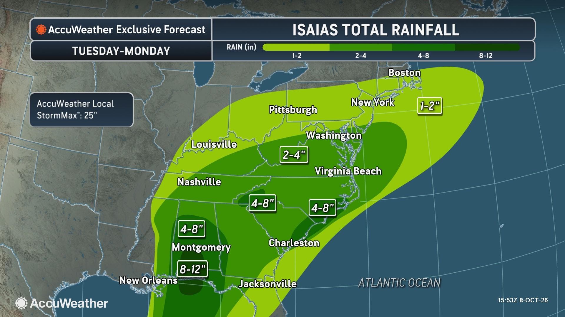
Bands of rainfall will come down Friday evening, through Saturday and into early Sunday morning, Hernandez said.
Travel could be affected Friday night and Saturday, and Isaias could spawn overnight tornadoes Friday and throughout Saturday, according to GEMA/HS.
Georgia On Alert
The Storm Prediction Center placed southwest and west-central Georgia under a slight risk for severe weather on Saturday, GEMA/HS stated.
In metro Atlanta, wind gusts of 40-60 mph are expected Saturday into Sunday morning. This can lead to power outages if power lines and trees fall, Hernandez confirmed.
Flooding may also be a concern as 2-3 inches of rain can overflow in Georgia, with locally higher amounts up to 5 inches anticipated.
RELATED: Tropical Storm Isaias Forms In Gulf: See GA Impacts
A flood watch will take effect at 2 a.m. Saturday and will expire at 8 a.m. Sunday for the entire metro Atlanta region and surrounding counties.
Major counties Fayette, Clayton, Henry, Cobb, Fulton, DeKalb and Gwinnett are all included. Notably, Cherokee, Douglas, Paulding, Hall, Bartow and Forsyth counties will also be under the watch.
"You should monitor later forecasts and be alert for possible flood warnings. Those living in areas prone to flooding should be prepared to take action should flooding develop," the NWS states in the alert.
The towns of Zebulon, Greenville, LaGrange, Cuthburt, Franklin and Thomaston are all under a tropical storm watch due to the chance of tropical storm-force winds occurring in the next two days.
Additionally, a high wind watch will take effect at 8 a.m. Saturday until 8 a.m. Sunday in metro Atlanta and surrounding areas.
Rainfall could linger Sunday, but north and central Georgia is expected to be dry by nightfall into early next week, Hernandez said.
If Isaias makes landfall as a hurricane, AccuWeather reported it will be the first hurricane to hit the U.S. since Hurricane Milton on Oct. 9, 2024.
“We’ve gone from a historic stretch without a hurricane to a potentially destructive storm threatening the Gulf Coast in a matter of days. El Niño has helped suppress hurricane activity across the Atlantic this season, but it hasn't eliminated the threat. Even in an unusually quiet season, it only takes one hurricane to have devastating consequences for communities in its path.”
AccuWeather expert meteorologist Dan Pydynowski
Updates will be posted on the weather service's Twitter page, the weather service's Facebook page and its website.
Get more local news delivered straight to your inbox. Sign up for free Patch newsletters and alerts.