Weather
Hurricane Lee Eyes Bermuda, Still 'Too Soon To Know' U.S. Impact
Hurricane Lee is expected to miss Georgia though a chance for thunderstorms remains through Wednesday for the Peach State.

GEORGIA — The trajectory of dangerous Hurricane Lee has the storm avoiding the southeastern coast of the U.S., showing the northeast could possibly feel impact from the powerful storm.
Meanwhile, Lee is expected to miss Georgia though a chance for thunderstorms remains through Wednesday for the Peach State.
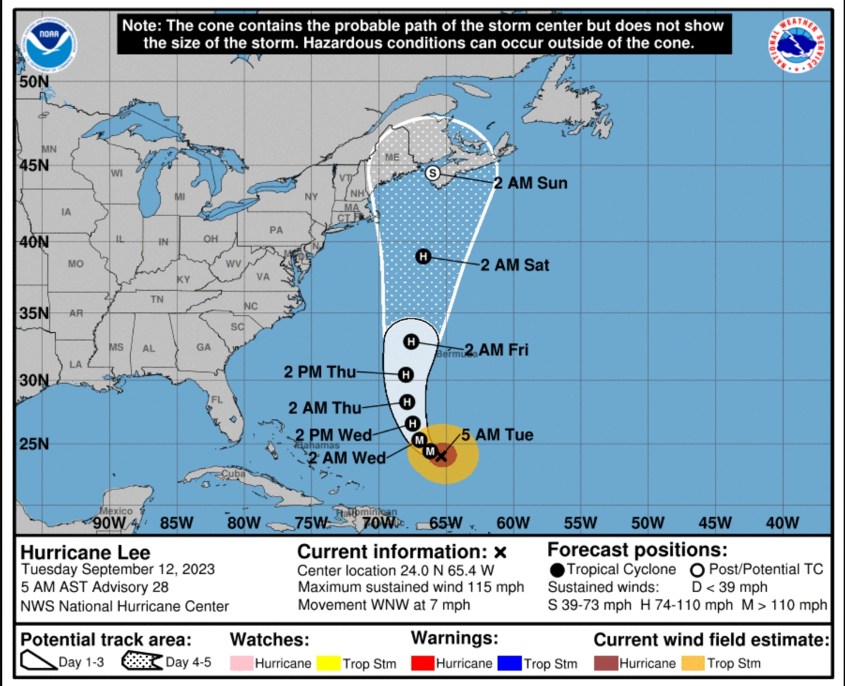
The National Hurricane Center said at its 5 a.m. Tuesday update that Lee is forecast to cause wind, rain and high surf impacts to Bermuda later in the week with tropical storm watches possible for the island Tuesday.
Find out what's happening in Atlantafor free with the latest updates from Patch.
Weather officials also anticipate Lee will bring threatening rip and surf currents to the northern Leeward Islands, the Virgin Islands, Puerto Rico, Hispaniola, the Turks and Caicos Islands and the Bahamas the majority of this week.
As of Tuesday morning, it was unknown what form of impact, if any, Lee could have on the northeast region of the U.S. and Canada the remainder of the week and the weekend.
Find out what's happening in Atlantafor free with the latest updates from Patch.
"However, since wind and rainfall hazards will extend well away from the center as Lee grows in size, users should continue to monitor updates to Lee's forecast during the next several days," the hurricane center said.
The National Weather Service did not have any alerts issued for metro Atlanta or Savannah. The weather service repeatedly told Patch last week that Lee should not be a concern for Georgia.
Temperatures for the metro are forecast to slightly cool down starting Wednesday, giving the area a break from scorching high-90 degree temperatures in recent weeks. Lows throughout the week are expected to be in the 60s.
The Tuesday high is forecast to be 90 degrees; however, residents may start to feel temperatures be a few degrees cooler Wednesday throughout the rest of the week.
At 9:30 a.m., the weather service predicted the following forecast for metro Atlanta:
Today: A 40 percent chance of showers and thunderstorms after 2 p.m. Mostly sunny, with a high near 90. South wind 5-10 mph becoming west in the afternoon.
Tonight: A 30 percent chance of showers and thunderstorms, mainly before 9 p.m. Patchy fog after 2 a.m. Otherwise, partly cloudy, with a low around 68. Southeast wind around 5 mph becoming calm after midnight.
Wednesday: A slight chance of showers between 1 p.m. and 2 p.m., then a slight chance of showers and thunderstorms after 2 p.m. Patchy fog before 9 a.m. Otherwise, mostly sunny, with a high near 85. Northwest wind 5-10 mph. Chance of precipitation is 20 percent.
Wednesday night: A slight chance of thunderstorms before 8 p.m. Partly cloudy, with a low around 64. North wind 5-10 mph. Chance of precipitation is 10 percent.
Thursday: Mostly sunny, with a high near 82. East wind around 10 mph, with gusts as high as 15 mph.
Thursday night: Partly cloudy, with a low around 64.
Friday: Mostly sunny, with a high near 81.
Friday night: Mostly clear, with a low around 62.
Saturday: A 20 percent chance of showers and thunderstorms after 2 p.m. Mostly sunny, with a high near 82.
Saturday night: A 20 percent chance of showers and thunderstorms. Partly cloudy, with a low around 63.
Sunday: A 30 percent chance of showers and thunderstorms. Mostly sunny, with a high near 80.
Sunday night: A 30 percent chance of showers and thunderstorms. Partly cloudy, with a low around 62.
Monday: Mostly sunny, with a high near 81.
Get more local news delivered straight to your inbox. Sign up for free Patch newsletters and alerts.