Weather
Lee To Miss Georgia While Other Storms, Cooler Temps Predicted: NWS
Though weather officials say Lee is too far into the Atlantic to be a concern for Georgia, other storms are forecast to enter metro Atlanta.

ATLANTA, GA — Though Hurricane Lee will miss Georgia this weekend, weather officials told Patch Thursday some storms may move into metro Atlanta.
Lee is too far into the Atlantic to be a concern for the Peach State, said Kyle Thiem, senior forecaster with the National Weather Service's Peachtree City office.
Friday is expected to be clear, but storms are forecast to come Saturday and last until later next week, Thiem said. No widespread severe weather is anticipated, and the cause of the storms will be a broad low pressure system coming across the southeast.
Find out what's happening in Atlantafor free with the latest updates from Patch.
As for Sunday, a cold front should push storms off to the eastern region. Thiem said the metro has a 20 percent chance of rain.
After a stint of temperatures in the high 90s, Thiem said cool down temperatures are arriving.
Find out what's happening in Atlantafor free with the latest updates from Patch.
"This is going to feel fantastic," he said.
Metro Atlanta temperatures will drop a bit into the mid-80s for Saturday and Sunday. Afterwards, temperatures will decrease to the lower 80s until Wednesday.
Morning lows should be in the mid-60s, making the area feel a bit cooler than usual.
"We are on a cool down over the next couple of days," Thiem said.
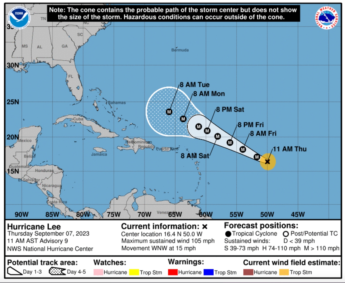
A Category 1 hurricane Thursday morning, Lee is forecast to rapidly strengthen and become a major hurricane, possibly a Category 4, by late Friday, according to the National Hurricane Center's 5 a.m. advisory.
As Lee travels over the warm waters of the Caribbean, the hurricane is expected to strengthen and potentially become a "catastrophic" Category 4 hurricane with sustained winds of 130-156 mph, the NHC said.
AccuWeather predicted Wednesday that Lee will strengthen into a Category 5 hurricane.
“Lee poses a risk to people from the northern Caribbean to the eastern Bahamas, the east coast of the United States, Bermuda and Atlantic Canada over the next week to 10 days," AccuWeather Chief Meteorologist Jonathan Porter said in a news release Wednesday.
"We strongly encourage people in this area to monitor the situation closely and check back with AccuWeather routinely, as it has the potential to become a powerhouse Category 5 hurricane, the strongest hurricane of the year.”
Although the hurricane is still heading west-northwest, weather officials said the hurricane took slight jog to the north, which could take the hurricane further north of the Leeward Islands than first predicted. This could mean that Lee will have little direct impact on the United States.
AccuWeather predicted Lee could affect eastern beaches next week by causing "rough surf and seas" and dangerous rip currents. Like the weather service, AccuWeather said Lee will likely not directly impact Georgia.
The weather service said Wednesday there are no major storms heading Georgia's way, aside from the state's usual weekend rain pattern.
The prediction comes a week after Hurricane Idalia slammed into Florida's Big Bend area as a strong Category 3 storm, bringing life-threatening storm surge, rainfall and damaging winds to an area that's never experienced such an event. Idalia then moved into Georgia and the Carolinas as a powerful tropical storm.
At 4 18 p.m. Thursday, the weather service predicted the following forecast for metro Atlanta:
This afternoon: A 20 percent chance of showers and thunderstorms. Mostly sunny, with a high near 88. West wind around 10 mph, with gusts as high as 15 mph.
Tonight: A 10 percent chance of showers and thunderstorms before 8 p.m. Mostly clear, with a low around 65. Northwest wind 5-10 mph.
Friday: Sunny, with a high near 86. Northwest wind around 5 mph.
Friday night: Mostly clear, with a low around 65. Northwest wind around 5 mph.
Saturday: A 50 percent chance of showers and thunderstorms after 3 p.m. Sunny, with a high near 86. Northeast wind 5-10 mph becoming south in the afternoon.
Saturday night: A 50 percent chance of showers and thunderstorms, mainly before 3 a.m. Partly cloudy, with a low around 66.
Sunday: A slight chance of showers and thunderstorms before 9 a.m., then a slight chance of showers and thunderstorms after 3 p.m. Mostly sunny, with a high near 84. Chance of precipitation is 20 percent.
Sunday night: A 20 percent chance of showers and thunderstorms before 9 p.m. Partly cloudy, with a low around 65.
Monday: Sunny, with a high near 87.
Monday night: Mostly clear, with a low around 67.
Tuesday: Mostly sunny, with a high near 88.
Tuesday night: A 20 percent chance of showers and thunderstorms. Partly cloudy, with a low around 67.
Wednesday: A 30 percent chance of showers and thunderstorms. Mostly sunny, with a high near 85.
Wednesday night: A 30 percent chance of showers and thunderstorms. Mostly cloudy, with a low around 64.
Thursday: A chance of showers. Mostly sunny, with a high near 82.
Get more local news delivered straight to your inbox. Sign up for free Patch newsletters and alerts.