Community Corner
Winter Storm Warning Issued; Accumulations 2-4 Inches; Walton Schools Make Decision
Winter Storm Warning issued for the Grayson-Loganville area beginning at 10 a.m. Wednesday.


Updated 10 p.m.
Walton County Schools announced classes will end two hours earlier than usual on Wednesday.
From the district’s Facebook post:
Find out what's happening in Loganville-Graysonfor free with the latest updates from Patch.
Early Dismissal Tomorrow, February 25th
Tomorrow, Wednesday, February 25th, 2015, school will be released 2 hours earlier than usual due to the likelihood of severe weather. Students will go home in the usual way. If they are bus riders they will arrive home 2 hours early, if they are car riders you should plan to pick them up 2 hours earlier than usual.
Find out what's happening in Loganville-Graysonfor free with the latest updates from Patch.
Updated 4:30 p.m.
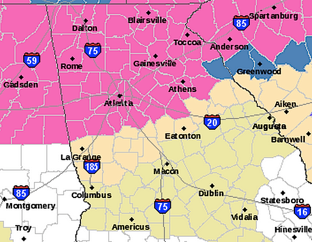
The National Weather Service in Peachtree City has issued a Winter Storm Warning for all of north Georgia, including Loganville and Grayson.
The warning is in effect from 10 a.m. Wednesday to 10 a.m. Thursday, during which time many places are expected to receive 2 or more inches of snow.
The Winter Storm Watch that had been issued earlier is no longer in effect.
The weather service said 2 to 4 inches are expected through most of north metro Atlanta and northward. Up to 6 inches might fall in the north Georgia mountains.
Amounts of 1 to 2 inches are possible in south metro Atlanta.
More from the National Weather Service:
A WINTER STORM WARNING FOR HEAVY SNOW MEANS SEVERE WINTER WEATHER CONDITIONS ARE EXPECTED OR OCCURRING. SIGNIFICANT AMOUNTS OF SNOW ARE FORECAST THAT WILL MAKE TRAVEL DANGEROUS. ONLY TRAVEL IN AN EMERGENCY.
IF YOU MUST TRAVEL...KEEP AN EXTRA FLASHLIGHT...FOOD...AND WATER IN YOUR VEHICLE IN CASE OF AN EMERGENCY. HEAVY...WET SNOW CAN BREAK TREE LIMBS AND DOWN POWER LINES... PARTICULARLY IN THE AREA IMPACTED BY LAST WEEK’S ICE STORM. STAY INDOORS AWAY FROM THESE HAZARDS...AND PREPARE FOR POWER OUTAGES BY HAVING FLASHLIGHTS AND EMERGENCY SUPPLIES READY.
-----
Original postThe layer of snow on the ground Tuesday morning is about to get a lot of company, according to the National Weather Service.
A Winter Storm Watch has been issued for the Loganville and Grayson area beginning at 10 a.m. Wednesday and ending at 7 a.m. Thursday.
The heaviest snow is expected to be between Wednesday evening and Thursday morning. The area could see 2 to 4 inches of snow, with up to 6 inches in the northeast Georgia mountains, according to the NWS.
Lower amounts are possible on the south side of the Atlanta Metro area, according to the NWS.
“Accumulations of snow along with freezing temperatures will result in slick roadways and make travel hazardous,” according to the NWS.
Get more local news delivered straight to your inbox. Sign up for free Patch newsletters and alerts.