Weather
Winter Storm Warning: Up To 12 Inches Predicted
A winter storm watch has been upgraded to a warning, with heavy, wet snow predicted — and as much as a foot in some areas.

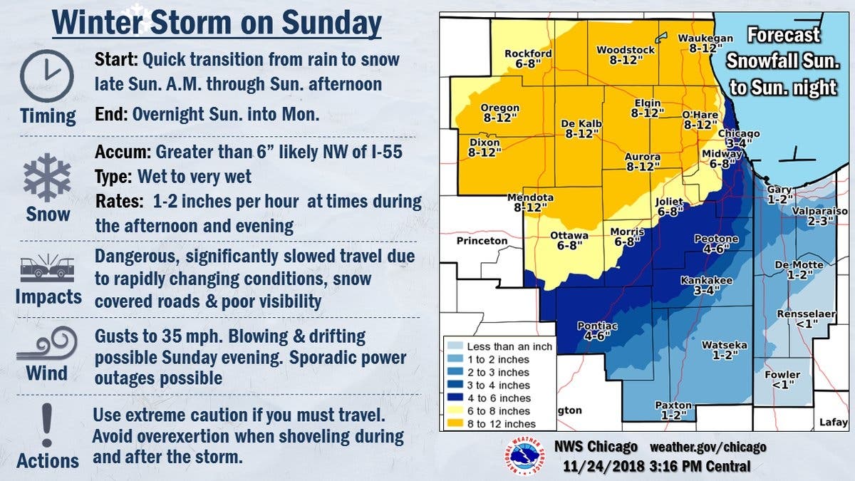
A winter storm warning has now been issued for most of the Chicago area. The warning takes effect at 10 a.m. Sunday for the Chicago area ahead of a potentially heavy snowfall. According to the NWS, DuPage, Cook, Kendall, Grundy, Will, Winnebago, Boone, McHenry, Ogle, Lee, Kane, De Kalb, La Salle and Lake counties all fall under the warning, which is in effect until 4 a.m. Monday.
A mix of rain and snow is expected to change to heavy, wet snow during the day Sunday across north central Illinois. The storm will then move southeast across the remainder of the winter storm warning area. The NWS said heavy snow is expected. Total snow accumulation of 7 to 10 inches, with localized amounts up to 12 inches, is also possible for some areas.
Travel could be difficult and snow-covered roads and reduced visibility are possible, the NWS said. Snowfall rates could exceed one inch per hour. There may also be a quick transition from rain to heavy, wet, slushy snow.
Find out what's happening in Arlington Heightsfor free with the latest updates from Patch.
Winds could also gust as high as 35 to 40 mph, so blowing snow is possible. Northerly winds will become gusty Sunday afternoon and night, the NWS said. In addition, the strong north winds will produce large waves on southern Lake Michigan, which may produce lakeshore flooding along the lake shore.
The NWS recommends keeping an eye on the latest forecasts and planning ahead if you will be traveling on Sunday. If you must travel, keep an extra flashlight, food and water in your vehicle in case of an emergency. The latest road conditions for the state you are calling from can be obtained by calling 511.
Find out what's happening in Arlington Heightsfor free with the latest updates from Patch.
Get more local news delivered straight to your inbox. Sign up for free Patch newsletters and alerts.