Weather
Record Heat Continues: Will We See A Break This Week?
An air quality alert has been issued for Monday for the Chicago area and temps in the 80s and 90s could continue through Tuesday.


The last five days have been brutally hot. For the fifth day in a row on Sunday, Chicago saw temps at or above 92 degrees, which marked only the third time in history the city has seen a five-day run of temps that high. The only major difference is the two other five-day stretches happened in July while this year's stretch occurred in late September.
On Sunday, a high of 92 degrees was recorded at O'Hare International Airport, which broke the previous record high for Sept. 24 set back in 1891. In addition to being the fifth consecutive day above 92 degrees, it was the fifth day in a row that a daily record high was set.
Find out what's happening in Chicagofor free with the latest updates from Patch.
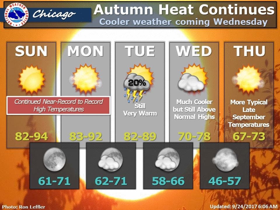
Monday is shaping up to be another hot one with near-record to record-high temps expected. Highs between 83 and 92 degrees are in the forecast. An air quality alert is also in effect on Monday for the Chicago are. Active children and adults, especially people with pulmonary or respiratory disease such as asthma, should limit prolonged outdoor activity, according to the National Weather Service.
(For more information on this and other neighborhood stories, subscribe to Patch to receive daily newsletters and breaking news alerts.)
Find out what's happening in Chicagofor free with the latest updates from Patch.
On Tuesday, the heat will continue with high temps between 82 and 89 degrees. There is also a slight chance for showers and thunderstorms Tuesday. Much cooler temps will finally enter the area on Wednesday, with highs between 70 and 78 degrees in the forecast. Those temps will still be above normal highs for this time of year.
Finally, on Thursday, we should see weather more typical for late September. High temps between 67 and 73 degrees are in the forecast.
With the heat returning in recent days, some Chicago-area residents have been searching for outdoor options to keep cool. Most area pools, beaches and splash pads —and other outdoor parks with water features—shut down over the Labor Day weekend.
But some towns, such as Lake in the Hills in McHenry Co., have decided to reopen such attractions. The splash pad at Sunset Park in Lake in the Hills has been reopened until fall-like temps return to give local residents and their kiddos a break from the heat. Followers to the What's Happening in Elgin IL? Facebook page noted the slash pad at Festival Park will be open from 10 a.m. to 8 p.m. through Oct. 1. Another option could be to check out the newly-renovated outdoor pool at Pheasant Run Resort in St. Charles. Day passes are available for $15 at the front desk of the resort but you may want to call ahead to make sure they are not sold out.
Water Wonders in North Aurora -- which was a tip provided by the popular blog site Go West Young Mom —could be a great outing as well. The Go West Young Mom blogger also solicited feedback from readers in a recent Facebook post, asking for spots with water features open after Labor Day and got these suggestions from readers: Oak Park Conservatory, the splash pad at Festival Park in Elgin, the children's garden at Morton Arboretum and Bison Bluff in Schaumburg. You should call ahead to check on these suggestions to make sure they are open.
Here is a more detailed look at the weather forecast for the coming days:
- SUNDAY NIGHT: Clear. Lows in the lower 60s outlying areas to around 70 downtown. Southeast winds around 10 mph becoming south 5 to 10 mph.
- MONDAY: Mostly sunny in the morning then becoming partly cloudy. Highs around 90 inland...but only in the mid 80s near the lake. South winds 5 to 10 mph becoming southeast in the afternoon.
- MONDAY NIGHT: Mostly clear in the evening then becoming partly cloudy. Lows from the lower 60s outlying areas to around 70 downtown. South winds 5 to 10 mph.
- TUESDAY: Partly cloudy. Highs in the upper 80s. Southwest winds 5 to 10 mph.
- TUESDAY NIGHT: Mostly cloudy with a 20 percent chance of showers. Turning cooler with lows from the upper 50s outlying areas to the mid 60s downtown. Northwest winds 5 to 10 mph.
- WEDNESDAY: Partly cloudy in the morning then clearing. Highs in the lower 70s.
- WEDNESDAY NIGHT: Mostly clear. Lows from the upper 40s outlying areas to the mid 50s downtown.
- THURSDAY: Mostly sunny. Highs around 70.
- THURSDAY NIGHT AND FRIDAY: Mostly clear. Lows from the upper 40s in the suburbs to the mid 50s downtown. Highs in the middle to upper 60s.
Get more local news delivered straight to your inbox. Sign up for free Patch newsletters and alerts.

