Community Corner
Your Weekend Chicagoland Weather Forecast
Humidity swept away by cold front. What to expect in the coming days.

By Patch Chicago
A cold front is moving through the Chicago area, bringing cooler temperatures for the weekend and next week.
“Behind the front, we should enter an extended period of cooler and MUCH less humid conditions,” says the National Weather Service. “From the middle of next week through next weekend the Climate Prediction Center is forecasting a high probability of below average temperatures. Normal highs by the end of next week drop into the mid 70s.”
Find out what's happening in Huntleyfor free with the latest updates from Patch.
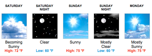
FORECASTS FOR THE NEXT FEW DAYS
- Friday Afternoon: A 50 percent chance of showers and thunderstorms, mainly after 3 p.m. Partly sunny, with a high near 88. North wind around 10 mph, with gusts as high as 15 mph.
- Tonight: A 50 percent chance of rain, mainly between 7 p.m. and 4 a.m. Cloudy, with a low around 64. North wind around 10 mph, with gusts as high as 15 mph.
- Saturday: Mostly cloudy, then gradually becoming sunny, with a high near 74. North wind 5 to 10 mph, with gusts as high as 15 mph.
- Saturday Night: Clear, with a low around 58. North wind around 5 mph becoming west northwest in the evening.
- Sunday: Sunny, with a high near 76. West northwest wind around 5 mph becoming calm in the morning.
- Sunday Night: Mostly clear, with a low around 61.
- Monday: Mostly sunny, with a high near 75.
- Monday Night: A slight chance of showers and thunderstorms.
Find out what's happening in Huntleyfor free with the latest updates from Patch.
Get more local news delivered straight to your inbox. Sign up for free Patch newsletters and alerts.