Weather
Flood Warnings Posted After Heavy Rains: MD Weather
Much of Maryland saw 2 inches of rain, which has caused flooding in several counties. Rivers are expected to rise through Monday.

MARYLAND — Rainfall amounts of more than 2 inches in some parts of Maryland have caused flooding along the Patapsco River and the threat of flooding continues in some areas Saturday, according to the National Weather Service.
Several flood warnings are in place, a wind advisory has been issued and a hazardous weather outlook has been posted for parts of Maryland.
The city of Frederick, plus Carroll, Baltimore, Montgomery, Howard and Harford counties are under the hazardous weather outlook through Saturday night, the weather service said.
Find out what's happening in Across Marylandfor free with the latest updates from Patch.
River flooding is likely, especially along the Potomac Basin and nearby tributaries later Saturday and through the night.
A wind advisory is in effect for northeastern Maryland until 6 p.m. Saturday. Cecil and Harford counties are in the advisory, including the cities of Elkton, Jarrettsville, and Aberdeen.
Find out what's happening in Across Marylandfor free with the latest updates from Patch.
River flooding is likely Sunday into Monday, especially along the Potomac Basin and nearby tributaries.
Heavier showers are slowly pivoting northeastward out of the this afternoon. Light showers are expected to continue on and off through Saturday evening, the NWS said.
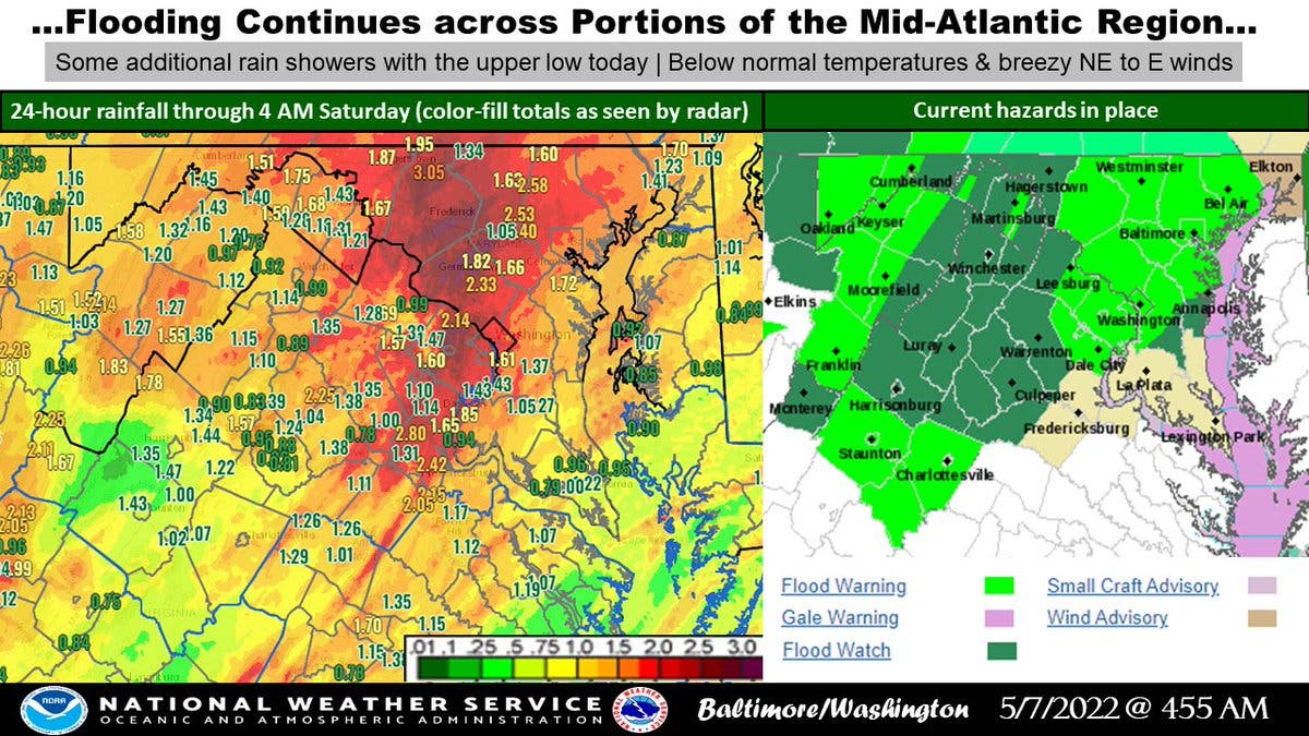
A flood warning is in effect until 5 p.m. Saturday for Anne Arundel, Howard and Baltimore counties.
A separate flood warning is in place until 6:15 p.m. Saturday for a portion of north central Maryland, including Carroll and Frederick counties.
Another half-inch of rain is possible in the warned area. Some locations that will experience flooding include: Frederick, Thurmont, Ballenger Creek, Mount Airy, Braddock Heights, New Market, Linganore-Bartonsville, Adamstown and Jefferson.
A flood warning has been issued for the Potomac River at Point of Rocks affecting Loudoun and Frederick counties, and at Edwards Ferry affecting Loudoun and Montgomery counties.
Small stream flooding caused by excessive rainfall is expected in parts of central and northern Maryland.
At 12:54 p.m., gauge reports indicated heavy rain had fallen. Flooding is already occurring in the warned area along the Patapsco River near Elkridge. Between 1.5 and 2.5 inches of rain have fallen.
At these river levels, Hammonds Ferry Road and Furnace Avenue are likely flooded. Some locations that will experience flooding include Elkridge, Catonsville, Arbutus, Brooklyn Park, Ilchester, Linthicum and Lansdowne.
By Saturday, the low-pressure system will begin to slide off the Maryland coast as the weather pattern across the U.S. is forecast to slow down, weather experts said.
The National Weather Service said this will lead to a very dreary weather pattern to develop and linger across Maryland and the Mid-Atlantic through the weekend. Residents should monitor later forecasts and be alert for possible flood warnings. Those living in areas prone to flooding should be prepared to take action should flooding develop.
Get more local news delivered straight to your inbox. Sign up for free Patch newsletters and alerts.