Weather
Nor’easter Isn’t Done Yet: What To Expect In Maryland This Weekend
The intensifying nor'easter is forecast to bring a fresh round of rain and strong wind gusts to Maryland. Here's what you can expect.


The nor'easter churning off the Atlantic coast isn't quite done with Maryland just yet, as rain, strong wind gusts and cloudy conditions return to the region.
The latest advisories issued by the National Weather Service put large parts of the state under coastal flood and gale warnings through much of the weekend.
Officials said a low water advisory could also be possible for areas north of Annapolis due to potential tidal blowout conditions.
Find out what's happening in Across Marylandfor free with the latest updates from Patch.
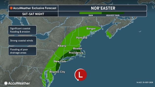
Saturday will offer mostly cloudy conditions, with the day's highest temperatures nearly hitting the 70s before plummeting back to the 50s. Wind gusts of up to nearly 30 mph will develop, with isolated gusts getting up to 40 mph.
Active Weather Advisories:
Find out what's happening in Across Marylandfor free with the latest updates from Patch.
- Coastal flood advisory in effect until 9 p.m. Friday for Anne Arundel County
- Coastal flood advisory in effect until 7 a.m. Saturday for Calvert County
- Coastal flood warning across Maryland beaches until 2 a.m. Sunday
- Gale warning in effect through 10 p.m. Saturday for coastal areas from the Chesapeake Bay to the Potomac River, Patuxent River and Susquehanna River.
Forecasters say the chance for wet weather begins after 1 p.m. Saturday and will stick around through Sunday, which will offer repeat weather conditions.
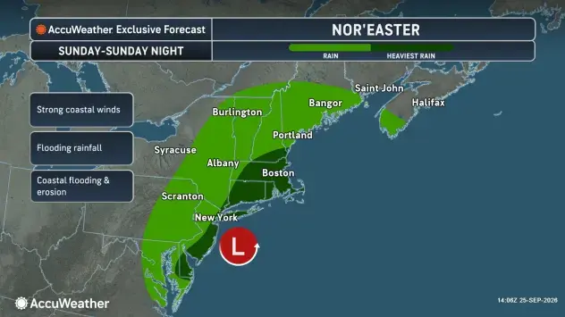
Between the two days, Sunday is expected to be more unsettled, although the nor'easter will be moving away from Maryland by nightfall.
The strongest storm impacts will be to the coastal areas and beaches, such as Ocean City, where the nor'easter prompted the cancellation of the Oceans Calling festival on Friday.
See Also:
- Here’s How Strengthening El Niño Could Shape Next Winter In MD
- 2026 Autumnal Equinox Is Tuesday: When It Will Feel Like Fall In MD
With rough surf anticipated through the weekend and significant beach erosion reported, forecasts suggest coastal areas could see between 1 to 2 feet of flooding in low-lying areas and wind gusts getting as strong as 50 mph at times.
An NWS advisory said waves of 8 to 12 feet were possible at state beaches.
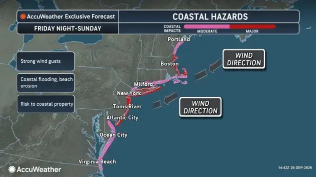
"This will be a long-duration event through multiple tide cycles well into this weekend, leading to major coastal flooding and beach erosion as well as strong winds pushing on trees for a longer period of time," AccuWeather Chief Meteorologist Jon Porter said in a report.
Porter warned that the storm could also prompt urban flooding and regional power outages further inland.
Detailed Forecast For Baltimore Region
Friday Afternoon: Partly sunny, with a high near 73. North wind around 18 mph, with gusts as high as 25 mph.
Friday Night: A slight chance of rain after 3am. Mostly cloudy, with a low around 57. North wind 11 to 14 mph, with gusts as high as 20 mph. Chance of precipitation is 20%.
Saturday: A chance of rain, mainly after 1pm. Mostly cloudy, with a high near 68. Breezy, with a north wind 15 to 20 mph, with gusts as high as 28 mph. Chance of precipitation is 30%.
Saturday Night: A chance of rain. Mostly cloudy, with a low around 57. North wind 11 to 13 mph. Chance of precipitation is 50%.
Sunday: A chance of rain. Mostly cloudy, with a high near 68. Breezy, with a northwest wind 13 to 21 mph, with gusts as high as 29 mph. Chance of precipitation is 50%.
Sunday Night: Mostly cloudy, with a low around 59.
Monday: Mostly cloudy, with a high near 71.
Monday Night: Mostly cloudy, with a low around 58.
Tuesday: Mostly sunny, with a high near 75.
Tuesday Night: Partly cloudy, with a low around 58.
Wednesday: Mostly sunny, with a high near 77.
Wednesday Night: Mostly cloudy, with a low around 61.
Thursday: Partly sunny, with a high near 79.
Get more local news delivered straight to your inbox. Sign up for free Patch newsletters and alerts.