Weather
Nor'easter To Slam MD With Severe Storms: What You Should Know
The fall season gets underway on Tuesday. But it's bringing with it a September nor'easter that has the potential to cause serious damage.


The start of the fall season means a shift to cooler temperatures, extra layers of clothing, and the occasional pumpkin spice latte. This week, however, it also means keeping an umbrella or rain jacket nearby.
Autumn officially begins Tuesday evening, but a September nor'easter is aiming to dump heavy rain, damaging winds, and bring the potential for serious coastal flooding.
The first round of rain comes Monday afternoon, according to the National Weather Service. Marylanders can expect showers to stick around through 3 p.m., although there is a possibility for thunderstorms to develop later in the day.
Find out what's happening in Across Marylandfor free with the latest updates from Patch.
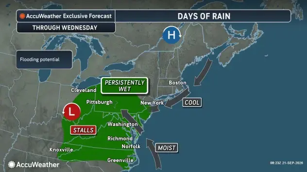
With 20-mph wind gusts forecast, officials say temperatures are likely to dip into the 50s.
The latest forecasts suggest the biggest chance for storms comes Tuesday, when rainfall amounts could be as high as three-quarters of an inch and wind gusts of nearly 30 mph could emerge.
Find out what's happening in Across Marylandfor free with the latest updates from Patch.
See Also:
Tuesday temperatures top out in the mid-60s before falling to about 55 degrees come nightfall.
Showers and thunderstorms will be possible all day.
While the chance for rain lessens Wednesday, the winds are not going anywhere. Officials say residents can expect to see a repeat of wind gusts hitting nearly 30 mph.
A Threatening Nor'easter
Depending on how the week's storms shift, Marylanders could see heavy rains prompt flash flooding, storm surge, and damaging winds, all of which will impact commuters.
Also of concern is the potential for downed trees and power outages across the Old Line State.
"The rain could extend far enough north to ease the ongoing drought in Maine," AccuWeather Senior Meteorologist Chad Merrill said in a statement.
"Regardless of how close to the coast the storm tracks, it has the potential to become strong enough to bring soaking rain and gusty winds in coastal areas, while prolonged rough surf may cause well-above-normal tides and beach erosion."
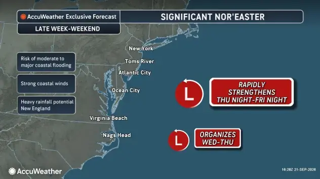
The storms, timed with the full moon's return, will see water levels pushed "even higher," according to AccuWeather.
Forecasts suggest serious coastal flooding could occur as a result on Wednesday, along the western side of the Chesapeake Bay and its tidal rivers.
Detailed Forecast For Baltimore Region
Monday Afternoon: Showers likely, mainly between 1 p.m. and 3 p.m. Cloudy, with a high near 74. Northeast wind around 10 mph. Chance of precipitation is 60%. New precipitation amounts of less than a tenth of an inch possible.
Monday Night: Showers and possibly a thunderstorm. Low around 59. Northeast wind around 9 mph, with gusts as high as 20 mph. Chance of precipitation is 80%. New rainfall amounts between a tenth and quarter of an inch, except higher amounts possible in thunderstorms.
Tuesday: Showers and possibly a thunderstorm. High near 66. Northeast wind 13 to 15 mph, with gusts as high as 26 mph. Chance of precipitation is 90%. New rainfall amounts between a half and three quarters of an inch possible.
Tuesday Night: Showers, mainly before 2 a.m. Low around 55. Northeast wind 11 to 14 mph, with gusts as high as 29 mph. Chance of precipitation is 80%. New precipitation amounts between a tenth and quarter of an inch possible.
Wednesday: A chance of showers. Mostly cloudy, with a high near 66. Northeast wind around 15 mph, with gusts as high as 26 mph. Chance of precipitation is 30%.
Wednesday Night: A slight chance of showers before 2 a.m. Mostly cloudy, with a low around 54. Chance of precipitation is 20%.
Thursday: Mostly cloudy, with a high near 66.
Thursday Night: Mostly cloudy, with a low around 52.
Friday: A slight chance of showers. Mostly sunny, with a high near 67. Chance of precipitation is 20%.
Friday Night: A chance of showers, mainly before 2 a.m. Mostly cloudy, with a low around 54. Chance of precipitation is 30%.
Saturday: A slight chance of showers. Partly sunny, with a high near 68. Chance of precipitation is 20%.
Saturday Night: Mostly cloudy, with a low around 55.
Sunday: Mostly sunny, with a high near 71.
Get more local news delivered straight to your inbox. Sign up for free Patch newsletters and alerts.