Weather
'Destructive' Nor'easter To Slam MD With Damaging Winds, Coastal Flooding
While the rain may have ended, powerful wind gusts are moving into the region and have prompted advisories through Friday.


After days of heavy rain across the state, the gloomy and chilly weather isn't quite done with Marylanders just yet, thanks to the September nor'easter.
Temperatures over the next few days will max out between the high 60s and low 70s, before falling to the 50s. But the real concern for forecasters is the wind gusts and coastal threats.
The National Weather Service says wind gusts impacting Maryland are expected to hit nearly 30 mph through Friday as both St. Mary's and Anne Arundel counties are put under weather advisories.
Find out what's happening in Across Marylandfor free with the latest updates from Patch.
Active Weather Advisories:
- Gale warning in effect for waters surrounding southern Maryland until Wednesday night
- Coastal flood warning in effect for St. Mary's County through Wednesday night
- Coastal flood watches in effect for St. Mary's and Anne Arundel counties through Friday
A coastal flood watch advisory by the NWS states tidal flooding along the Anne Arundel County shoreline could produce "up to one foot of inundation above ground level" in low lying areas.
Find out what's happening in Across Marylandfor free with the latest updates from Patch.
Flooding is anticipated in Annapolis' City Dock area.
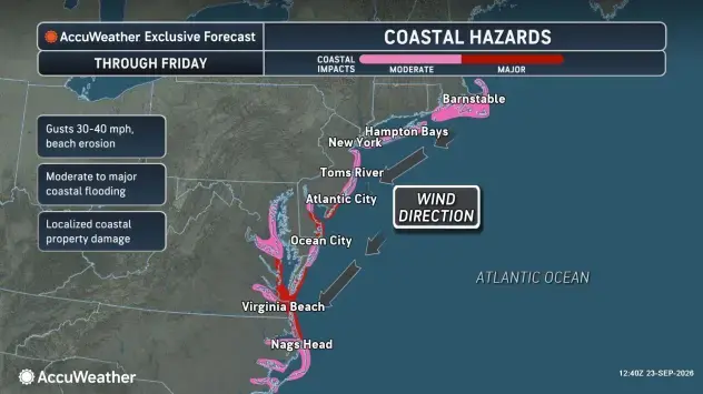
AccuWeather reported the coastal hazards were developing as a result of the high pressure from the interior Northeast region and the growing low pressure off the mid-Atlantic coastline.
See Also:
- Here’s How Strengthening El Niño Could Shape Next Winter In MD
- 2026 Autumnal Equinox Is Tuesday: When It Will Feel Like Fall In MD
The worst conditions are expected to develop in neighboring Virginia, specifically around the southeastern part of the state.
"This storm may be remembered for its destructive coastal flooding and severe beach erosion," AccuWeather Chief Meteorologist Jon Porter said.
Detailed Forecast For Baltimore Region
Wednesday Afternoon: Cloudy, with a high near 64. Northeast wind around 14 mph, with gusts as high as 26 mph.
Wednesday Night: Mostly cloudy, then gradually becoming mostly clear, with a low around 52. Northeast wind 10 to 13 mph, with gusts as high as 28 mph.
Thursday: Partly sunny, with a high near 68. Northeast wind 11 to 13 mph, with gusts as high as 22 mph.
Thursday Night: Mostly cloudy, with a low around 53. North wind 6 to 8 mph.
Friday: Mostly sunny, with a high near 72. North wind 10 to 13 mph, with gusts as high as 22 mph.
Friday Night: Partly cloudy, with a low around 55.
Saturday: Mostly sunny, with a high near 75.
Saturday Night: Partly cloudy, with a low around 57.
Sunday: Mostly sunny, with a high near 74.
Sunday Night: Mostly cloudy, with a low around 57.
Monday: Mostly sunny, with a high near 75.
Monday Night: Partly cloudy, with a low around 56.
Tuesday: Sunny, with a high near 79.
Get more local news delivered straight to your inbox. Sign up for free Patch newsletters and alerts.